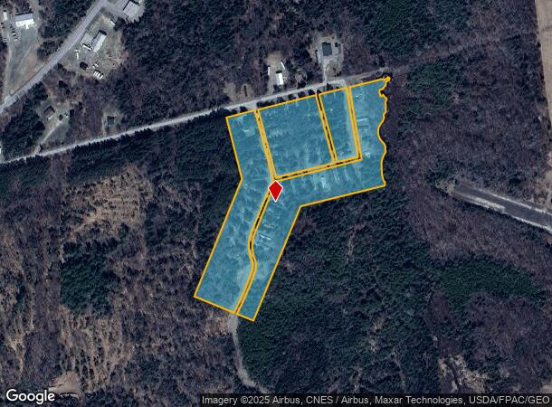
Property Record
Old Woodstock Rd, Houlton, ME 04730
NEARBY LISTINGS FOR SALE OR LEASE
-
-
View all Houlton listings for sale on LoopNet.com
Property Detail
Old Woodstock Rd
Other Market Areas
Aroostook
HOUL-000035-000000-000024
Maine
Commercialacreage
24
2025
18.40 AC
2025
Maine North & Bangor
952500
DEMOGRAPHICS near Old Woodstock Rd
1 Mile
3 Mile
5 Mile
2024 Total Population
392
5,965
6,836
2029 Population
394
6,068
6,940
Pop Growth 2024-2029
+ 0.51%
+ 1.73%
+ 1.52%
Average Age
46
44
44
2024 Total Households
158
2,539
2,906
HH Growth 2024-2029
+ 0.63%
+ 1.81%
+ 1.58%
Median Household Inc
$63,214
$64,808
$64,105
Avg Household Size
2.20
2.20
2.20
2024 Avg HH Vehicles
2.00
2.00
2.00
Median Home Value
$122,727
$141,307
$144,943
Median Year Built
1955
1960
1962
Nearby Places
Map Layers
Map Styles
 Street
 Aerial
- Restaurants
- Banks
- Shops
- Fitness
- Groceries
SALE & LEASE HISTORY
LISTING DATE
SALE/LEASE

Sep 27, 2017
For Sale
Sep 01, 2017
For Sale
Jun 01, 2017
For Sale
Aug 23, 2017
For Sale
Nearby Properties
Address
Land Use
TOTAL SIZE
Lot Size
Zoning
Address
Land Use
TOTAL SIZE
Lot Size
Zoning
29 AC
LOW DE
Address
Land Use
TOTAL SIZE
Lot Size
Zoning
29 AC
LOW DE
Address
Land Use
TOTAL SIZE
Lot Size
Zoning
103.12 AC
RB
Address
Land Use
TOTAL SIZE
Lot Size
Zoning
75,114 SF
11.36 AC
BB
Address
Land Use
TOTAL SIZE
Lot Size
Zoning
36,000 SF
4.04 AC
IB
Address
Land Use
TOTAL SIZE
Lot Size
Zoning
14,690 SF
3.02 AC
BB
Address
Land Use
TOTAL SIZE
Lot Size
Zoning
4.50 AC
TRANSI
Address
Land Use
TOTAL SIZE
Lot Size
Zoning
Address
Land Use
TOTAL SIZE
Lot Size
Zoning
25 AC
RA
Address
Land Use
TOTAL SIZE
Lot Size
Zoning
11,762 SF
0.29 AC
RA
Address
Land Use
TOTAL SIZE
Lot Size
Zoning
19,362 SF
20 AC
RURAL
Address
Land Use
TOTAL SIZE
Lot Size
Zoning
22,428 SF
5 AC
BB
Address
Land Use
TOTAL SIZE
Lot Size
Zoning
30,535 SF
23 AC
RA
Address
Land Use
TOTAL SIZE
Lot Size
Zoning
10,822 SF
2.30 AC
RURAL
Address
Land Use
TOTAL SIZE
Lot Size
Zoning
35,352 SF
2.64 AC
B
Address
Land Use
TOTAL SIZE
Lot Size
Zoning
3.80 AC
TRANSI
Address
Land Use
TOTAL SIZE
Lot Size
Zoning
1.24 AC
B
Address
Land Use
TOTAL SIZE
Lot Size
Zoning
35,364 SF
5.12 AC
RA
Address
Land Use
TOTAL SIZE
Lot Size
Zoning
31,467 SF
18.15 AC
BB
Address
Land Use
TOTAL SIZE
Lot Size
Zoning
20.24 AC
HIGHWA
Address
Land Use
TOTAL SIZE
Lot Size
Zoning
25,600 SF
2.80 AC
RB
Address
Land Use
TOTAL SIZE
Lot Size
Zoning
7 AC
BB
Address
Land Use
TOTAL SIZE
Lot Size
Zoning
43,624 SF
3.85 AC
BB
Address
Land Use
TOTAL SIZE
Lot Size
Zoning
36,870 SF
2.60 AC
RB
Address
Land Use
TOTAL SIZE
Lot Size
Zoning
24,411 SF
0.66 AC
B
Address
Land Use
TOTAL SIZE
Lot Size
Zoning
15,295 SF
2 AC
B
Address
Land Use
TOTAL SIZE
Lot Size
Zoning
20,600 SF
2.55 AC
RURAL
Address
Land Use
TOTAL SIZE
Lot Size
Zoning
30,012 SF
0.58 AC
B
Address
Land Use
TOTAL SIZE
Lot Size
Zoning
18,888 SF
10 AC
BB
Address
Land Use
TOTAL SIZE
Lot Size
Zoning
18,380 SF
0.75 AC
RB
The World's #1 Commercial Real Estate Marketplace
Connect with us
© 2025 CoStar Group
The information above has been obtained from sources believed reliable. While we do not doubt its accuracy we have not verified it and make no guarantee, warranty or representation about it. It is your responsibility to independently confirm its accuracy and completeness. Any projections, opinions, assumptions, or estimates used are for example only and do not represent the current or future performance of the property. The value of this transaction to you depends on tax and other factors which should be evaluated by your tax, financial, and legal advisors. You and your advisors should conduct a careful, independent investigation of the property to determine to your satisfaction the suitability of the property for your needs.