Property Record
Olive Ave, San Bernardino, CA 92407
NEARBY LISTINGS FOR SALE OR LEASE
Property Detail
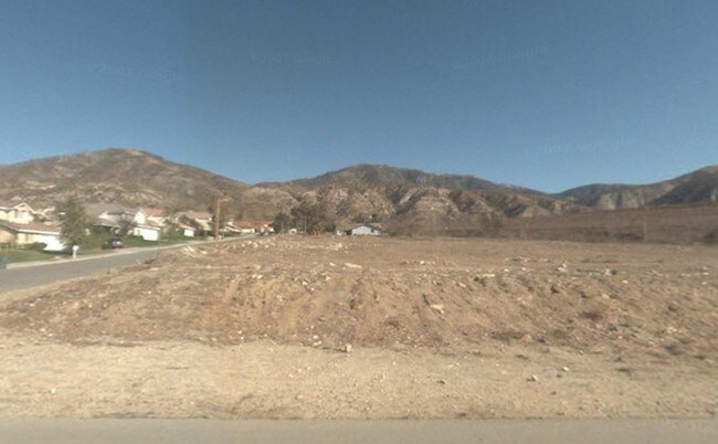
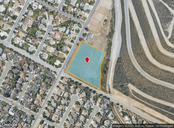
Olive Ave
Riverside-San Bernardino-Ontario, CA
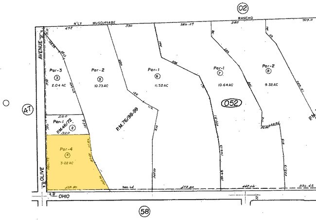
Parcel Map No 7050
0261-052-04
PARCEL MAP 7050 PARCEL NO 4 AND PTN OF OLIVE AVE VAC ADJ ON W AND OHIO AVE VAC ADJ ON S PER 7-27-88 #88-245369
Vacantlandnec
San Bernardino
A
California
06071C7930J
3.02 AC
2024
San Bernardino
2025
Inland Empire (California)
004601
DEMOGRAPHICS near Olive Ave
1 Mile
3 Mile
5 Mile
2024 Total Population
8,634
31,351
114,254
2029 Population
8,778
31,829
115,415
Pop Growth 2024-2029
+ 1.67%
+ 1.52%
+ 1.02%
Average Age
36
34
35
2024 Total Households
2,583
8,953
32,834
HH Growth 2024-2029
+ 1.55%
+ 1.53%
+ 0.86%
Median Household Inc
$105,724
$84,190
$80,582
Avg Household Size
3.30
3.30
3.30
2024 Avg HH Vehicles
3.00
2.00
2.00
Median Home Value
$481,276
$415,301
$421,162
Median Year Built
1993
1987
1978
Nearby Places
- Restaurants
- Banks
- Shops
- Fitness
- Groceries
PUBLIC TRANSPORTATION
COMMUTER RAIL
San Bernardino (Inland Empire-Orange County Line - Southern California Regional Rail Authority (Metrolink), San Bernardino Line - Southern California Regional Rail Authority (Metrolink))
DRIVE
WALK
Distance
San Bernardino (Inland Empire-Orange County Line - Southern California Regional Rail Authority (Metrolink), San Bernardino Line - Southern California Regional Rail Authority (Metrolink))
13 min
9.1 mi
AIRPORT
Ontario International
DRIVE
WALK
Distance
Ontario International
30 min
22.7 mi
Freight Ports
Port of Long Beach
DRIVE
WALK
Distance
Port of Long Beach
92 min
74.8 mi
Nearby Properties
Address
Land Use
TOTAL SIZE
Lot Size
Zoning
Address
Land Use
TOTAL SIZE
Lot Size
Zoning
183,030 SF
62.05 AC
Address
Land Use
TOTAL SIZE
Lot Size
Zoning
805,980 SF
39.57 AC
Address
Land Use
TOTAL SIZE
Lot Size
Zoning
830,613 SF
35.21 AC
Address
Land Use
TOTAL SIZE
Lot Size
Zoning
335,460 SF
16.45 AC
Address
Land Use
TOTAL SIZE
Lot Size
Zoning
340,057 SF
14.43 AC
Address
Land Use
TOTAL SIZE
Lot Size
Zoning
250,111 SF
12.04 AC
Address
Land Use
TOTAL SIZE
Lot Size
Zoning
730,988 SF
32.09 AC
GHSP
Address
Land Use
TOTAL SIZE
Lot Size
Zoning
843,440 SF
35.85 AC
Address
Land Use
TOTAL SIZE
Lot Size
Zoning
624,376 SF
37.65 AC
Address
Land Use
TOTAL SIZE
Lot Size
Zoning
671,229 SF
19.50 AC
Address
Land Use
TOTAL SIZE
Lot Size
Zoning
214,534 SF
17.98 AC
Address
Land Use
TOTAL SIZE
Lot Size
Zoning
127,176 SF
18.55 AC
Address
Land Use
TOTAL SIZE
Lot Size
Zoning
321,496 SF
21.24 AC
Address
Land Use
TOTAL SIZE
Lot Size
Zoning
52,258 SF
8.90 AC
Address
Land Use
TOTAL SIZE
Lot Size
Zoning
211,703 SF
12.34 AC
Address
Land Use
TOTAL SIZE
Lot Size
Zoning
76,234 SF
24.42 AC
Address
Land Use
TOTAL SIZE
Lot Size
Zoning
392,650 SF
20.14 AC
Address
Land Use
TOTAL SIZE
Lot Size
Zoning
226,072 SF
20.42 AC
Address
Land Use
TOTAL SIZE
Lot Size
Zoning
248,368 SF
19.34 AC
Address
Land Use
TOTAL SIZE
Lot Size
Zoning
326,094 SF
18.08 AC
Address
Land Use
TOTAL SIZE
Lot Size
Zoning
158,804 SF
5.63 AC
Address
Land Use
TOTAL SIZE
Lot Size
Zoning
272,408 SF
18.41 AC
Address
Land Use
TOTAL SIZE
Lot Size
Zoning
152,714 SF
9.99 AC
Address
Land Use
TOTAL SIZE
Lot Size
Zoning
254,500 SF
11.58 AC
Address
Land Use
TOTAL SIZE
Lot Size
Zoning
150,200 SF
10.08 AC
Address
Land Use
TOTAL SIZE
Lot Size
Zoning
191,216 SF
10.28 AC
Address
Land Use
TOTAL SIZE
Lot Size
Zoning
103,370 SF
5.07 AC
GHSP
Address
Land Use
TOTAL SIZE
Lot Size
Zoning
137,200 SF
10.07 AC
Address
Land Use
TOTAL SIZE
Lot Size
Zoning
135,000 SF
8.62 AC
Address
Land Use
TOTAL SIZE
Lot Size
Zoning
173,958 SF
4.88 AC
The World's #1 Commercial Real Estate Marketplace
Connect with us
© 2025 CoStar Group
The information above has been obtained from sources believed reliable. While we do not doubt its accuracy we have not verified it and make no guarantee, warranty or representation about it. It is your responsibility to independently confirm its accuracy and completeness. Any projections, opinions, assumptions, or estimates used are for example only and do not represent the current or future performance of the property. The value of this transaction to you depends on tax and other factors which should be evaluated by your tax, financial, and legal advisors. You and your advisors should conduct a careful, independent investigation of the property to determine to your satisfaction the suitability of the property for your needs.