Property Record
Meijer Dr, Cincinnati, OH 45240

NEARBY LISTINGS FOR SALE OR LEASE
Property Detail
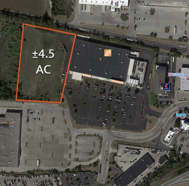
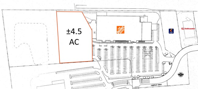
Meijer Dr
591-0027-0079
MEIJER DR 5.9177 ACSR2 - T2 - S25
Municipalproperty
Hamilton
X
Ohio
39017C0317F
5.92 AC
0
Forest Park/West
2025
Cincinnati/Dayton
021572
Cincinnati, OH-KY-IN
DEMOGRAPHICS near Meijer Dr
1 Mile
3 Mile
5 Mile
2024 Total Population
6,310
77,782
153,021
2029 Population
6,219
78,126
153,278
Pop Growth 2024-2029
(1.44%)
+ 0.44%
+ 0.17%
Average Age
40
40
40
2024 Total Households
2,460
30,955
60,523
HH Growth 2024-2029
(1.63%)
+ 0.64%
+ 0.21%
Median Household Inc
$67,090
$63,516
$63,805
Avg Household Size
2.50
2.40
2.40
2024 Avg HH Vehicles
2.00
2.00
2.00
Median Home Value
$171,837
$166,755
$165,963
Median Year Built
1976
1975
1973
Nearby Places
Map Layers
Map Styles
 Street
 Aerial
- Restaurants
- Banks
- Shops
- Fitness
- Groceries
PUBLIC TRANSPORTATION
AIRPORT
Cincinnati/Northern Kentucky International
DRIVE
WALK
Distance
Cincinnati/Northern Kentucky International
39 min
32.6 mi
SALE & LEASE HISTORY
LISTING DATE
SALE/LEASE

May 06, 2022
For Sale
Apr 21, 2021
For Sale
Nearby Properties
Address
Land Use
TOTAL SIZE
Lot Size
Zoning
Address
Land Use
TOTAL SIZE
Lot Size
Zoning
38,880 SF
20.93 AC
Address
Land Use
TOTAL SIZE
Lot Size
Zoning
34.60 AC
Address
Land Use
TOTAL SIZE
Lot Size
Zoning
87,612 SF
16.29 AC
R3
Address
Land Use
TOTAL SIZE
Lot Size
Zoning
1,363,493 SF
75.28 AC
Address
Land Use
TOTAL SIZE
Lot Size
Zoning
52,548 SF
39.18 AC
Address
Land Use
TOTAL SIZE
Lot Size
Zoning
39.89 AC
Address
Land Use
TOTAL SIZE
Lot Size
Zoning
54.77 AC
Address
Land Use
TOTAL SIZE
Lot Size
Zoning
115,446 SF
20.08 AC
Address
Land Use
TOTAL SIZE
Lot Size
Zoning
2.24 AC
Address
Land Use
TOTAL SIZE
Lot Size
Zoning
4,849 SF
19.98 AC
Address
Land Use
TOTAL SIZE
Lot Size
Zoning
20.68 AC
Address
Land Use
TOTAL SIZE
Lot Size
Zoning
1,700 SF
35.39 AC
Address
Land Use
TOTAL SIZE
Lot Size
Zoning
111,993 SF
17.34 AC
Address
Land Use
TOTAL SIZE
Lot Size
Zoning
357,452 SF
26.77 AC
Address
Land Use
TOTAL SIZE
Lot Size
Zoning
279,161 SF
28.02 AC
Address
Land Use
TOTAL SIZE
Lot Size
Zoning
3,538 SF
23.40 AC
Address
Land Use
TOTAL SIZE
Lot Size
Zoning
3,894 SF
14.54 AC
Address
Land Use
TOTAL SIZE
Lot Size
Zoning
15.83 AC
Address
Land Use
TOTAL SIZE
Lot Size
Zoning
24.45 AC
Address
Land Use
TOTAL SIZE
Lot Size
Zoning
5,073 SF
14.07 AC
Address
Land Use
TOTAL SIZE
Lot Size
Zoning
183,864 SF
25.85 AC
Address
Land Use
TOTAL SIZE
Lot Size
Zoning
22.02 AC
Address
Land Use
TOTAL SIZE
Lot Size
Zoning
150,620 SF
13.73 AC
Address
Land Use
TOTAL SIZE
Lot Size
Zoning
462,994 SF
25.63 AC
Address
Land Use
TOTAL SIZE
Lot Size
Zoning
333,379 SF
22.22 AC
Address
Land Use
TOTAL SIZE
Lot Size
Zoning
469,454 SF
36.44 AC
Address
Land Use
TOTAL SIZE
Lot Size
Zoning
17.28 AC
Address
Land Use
TOTAL SIZE
Lot Size
Zoning
143,569 SF
10.43 AC
Address
Land Use
TOTAL SIZE
Lot Size
Zoning
26.33 AC
Address
Land Use
TOTAL SIZE
Lot Size
Zoning
26.89 AC
The World's #1 Commercial Real Estate Marketplace
Connect with us
© 2026 CoStar Group
The information above has been obtained from sources believed reliable. While we do not doubt its accuracy we have not verified it and make no guarantee, warranty or representation about it. It is your responsibility to independently confirm its accuracy and completeness. Any projections, opinions, assumptions, or estimates used are for example only and do not represent the current or future performance of the property. The value of this transaction to you depends on tax and other factors which should be evaluated by your tax, financial, and legal advisors. You and your advisors should conduct a careful, independent investigation of the property to determine to your satisfaction the suitability of the property for your needs.