Property Record
Orange Tree Ln, Redlands, CA 92374
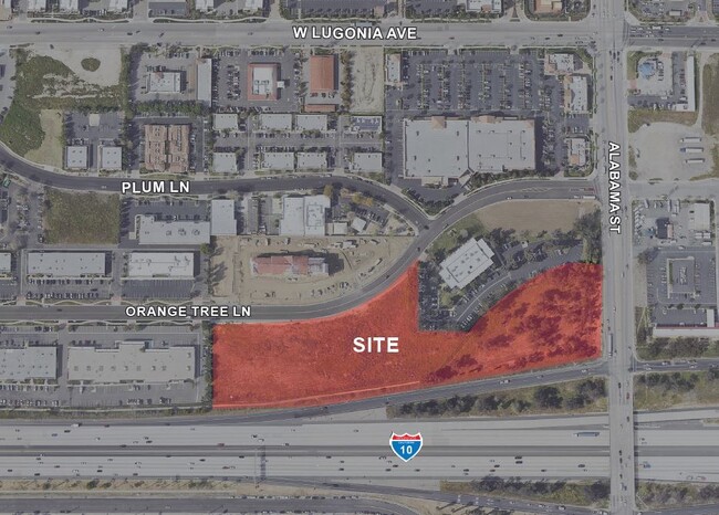
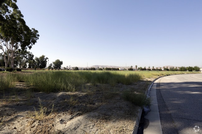
This Property Is For Sale
Property Detail
Orange Tree Ln
Riverside-San Bernardino-Ontario, CA
PARCEL MAP NO. 8132 PORTION OF PARCEL 3 OF AND A PORTION OF LOT 8, BLOCK 4, HENRY L. WILLIAMS TRACT DESCRIBED AS FOLLOWS: COMMENCING AT THE NORTHWEST CORNER OF PARCEL 4 OF SAID PARCEL MAP NO. 8132, SAID NORTHWEST CORNER BEING A POINT ON THE SOUTHERLY
0292-062-21
SAN BERNARDINO
Vacantlandnec
California
B and X Area of moderate flood hazard, usually the area between the limits of the 100-year and 500-year floods.
8
2025
1.79 AC
2025
Redlands/Loma Linda
008405
Inland Empire (California)
NEARBY LISTINGS FOR SALE OR LEASE
DEMOGRAPHICS near Orange Tree Ln
1 mile
3 mile
5 mile
2025 Total Population
2,651
79,424
209,624
2030 Population
2,862
80,973
212,941
Pop Growth 2025-2030
+ 7.96%
+ 1.95%
+ 1.58%
Average Age
35
38
38
2025 Total Households
1,195
28,467
69,389
HH Growth 2025-2030
+ 7.87%
+ 2.04%
+ 1.67%
Median Household Inc
$84,016
$90,732
$85,365
Avg Household Size
2.20
2.60
2.90
2025 Avg HH Vehicles
2.00
2.00
2.00
Median Home Value
$476,666
$625,096
$566,701
Median Year Built
2010
1978
1979
Nearby Places
Map Layers
Map Styles
 Street
 Aerial
Layers
 Traffic
 Biking
Places
Listings with unknown addresses are not visible on the map
- Restaurants
- Banks
- Shops
- Fitness
- Groceries
PUBLIC TRANSPORTATION
COMMUTER RAIL
Redlands - Esri Metrolink Station (Metrolink San Bernardino Line - Metrolink Trains)
Drive
Walk
Distance
Redlands - Esri Metrolink Station (Metrolink San Bernardino Line - Metrolink Trains)
4 min
1.5 mi
Redlands - Downtown Metrolink Station (Metrolink San Bernardino Line - Metrolink Trains)
Drive
Walk
Distance
Redlands - Downtown Metrolink Station (Metrolink San Bernardino Line - Metrolink Trains)
6 min
2.3 mi
AIRPORT
Ontario International
Drive
Walk
Distance
Ontario International
31 min
23.7 mi
Freight Ports
Port of Long Beach
Drive
Walk
Distance
Port of Long Beach
88 min
69.0 mi
Nearby Properties
Address
Land Use
TOTAL SIZE
Lot Size
Zoning
Address
Land Use
TOTAL SIZE
Lot Size
Zoning
1,079,470 SF
46.39 AC
Address
Land Use
TOTAL SIZE
Lot Size
Zoning
1,079,236 SF
54.70 AC
EVIR
Address
Land Use
TOTAL SIZE
Lot Size
Zoning
393,088 SF
25.98 AC
Address
Land Use
TOTAL SIZE
Lot Size
Zoning
708,500 SF
97.74 AC
Address
Land Use
TOTAL SIZE
Lot Size
Zoning
345,158 SF
36.95 AC
Address
Land Use
TOTAL SIZE
Lot Size
Zoning
445,160 SF
24.11 AC
Address
Land Use
TOTAL SIZE
Lot Size
Zoning
460,038 SF
22.70 AC
Address
Land Use
TOTAL SIZE
Lot Size
Zoning
589,602 SF
36.89 AC
Address
Land Use
TOTAL SIZE
Lot Size
Zoning
1,313,470 SF
60.31 AC
Address
Land Use
TOTAL SIZE
Lot Size
Zoning
1,012,980 SF
50.48 AC
Address
Land Use
TOTAL SIZE
Lot Size
Zoning
105,803 SF
10.86 AC
Address
Land Use
TOTAL SIZE
Lot Size
Zoning
417,188 SF
21.54 AC
Address
Land Use
TOTAL SIZE
Lot Size
Zoning
329,075 SF
10.93 AC
Address
Land Use
TOTAL SIZE
Lot Size
Zoning
614,292 SF
27.84 AC
Address
Land Use
TOTAL SIZE
Lot Size
Zoning
771,907 SF
35.59 AC
Address
Land Use
TOTAL SIZE
Lot Size
Zoning
69,495 SF
3.04 AC
RM
Address
Land Use
TOTAL SIZE
Lot Size
Zoning
784,280 SF
34.62 AC
EVSDCOM
Address
Land Use
TOTAL SIZE
Lot Size
Zoning
983,986 SF
47.60 AC
Address
Land Use
TOTAL SIZE
Lot Size
Zoning
606,450 SF
27.91 AC
EVSDCOM
Address
Land Use
TOTAL SIZE
Lot Size
Zoning
56.83 AC
Address
Land Use
TOTAL SIZE
Lot Size
Zoning
809,679 SF
37.19 AC
Address
Land Use
TOTAL SIZE
Lot Size
Zoning
951,686 SF
47.90 AC
Address
Land Use
TOTAL SIZE
Lot Size
Zoning
777,580 SF
23.13 AC
Address
Land Use
TOTAL SIZE
Lot Size
Zoning
801,126 SF
36.03 AC
Address
Land Use
TOTAL SIZE
Lot Size
Zoning
683,406 SF
31.38 AC
Address
Land Use
TOTAL SIZE
Lot Size
Zoning
703,479 SF
33.53 AC
Address
Land Use
TOTAL SIZE
Lot Size
Zoning
291,560 SF
7.19 AC
Address
Land Use
TOTAL SIZE
Lot Size
Zoning
593,615 SF
27.54 AC
EVCG
Address
Land Use
TOTAL SIZE
Lot Size
Zoning
542,519 SF
27.07 AC
Address
Land Use
TOTAL SIZE
Lot Size
Zoning
121,035 SF
36.62 AC
The World's #1 Commercial Real Estate Marketplace
Connect with us
© 2026 CoStar Group
The information above has been obtained from sources believed reliable. While we do not doubt its accuracy we have not verified it and make no guarantee, warranty or representation about it. It is your responsibility to independently confirm its accuracy and completeness. Any projections, opinions, assumptions, or estimates used are for example only and do not represent the current or future performance of the property. The value of this transaction to you depends on tax and other factors which should be evaluated by your tax, financial, and legal advisors. You and your advisors should conduct a careful, independent investigation of the property to determine to your satisfaction the suitability of the property for your needs.