Property Record
Oregon Pike, Lancaster, PA 17601
NEARBY LISTINGS FOR SALE OR LEASE
Property Detail
Oregon Pike
Lancaster, PA
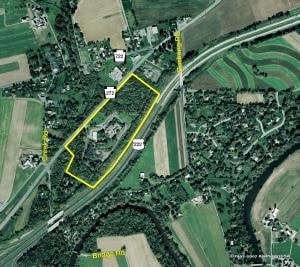
3001 OREGON PIKE
390-43511-0-0000
Lancaster
Commercialacreage
Pennsylvania
X
2
42071C0376F
8.06 AC
2024
Lancaster County
2025
Philadelphia
011806
DEMOGRAPHICS near Oregon Pike
1 Mile
3 Mile
5 Mile
2024 Total Population
711
27,091
96,597
2029 Population
700
27,348
97,491
Pop Growth 2024-2029
(1.55%)
+ 0.95%
+ 0.93%
Average Age
47
44
43
2024 Total Households
269
10,036
36,815
HH Growth 2024-2029
(2.23%)
+ 1.08%
+ 0.99%
Median Household Inc
$95,065
$89,575
$85,367
Avg Household Size
2.50
2.50
2.50
2024 Avg HH Vehicles
2.00
2.00
2.00
Median Home Value
$342,045
$297,614
$273,595
Median Year Built
1979
1981
1980
Nearby Places
Map Layers
Map Styles
 Street
 Aerial
- Restaurants
- Banks
- Shops
- Fitness
- Groceries
PUBLIC TRANSPORTATION
COMMUTER RAIL
Lancaster (Keystone Service - Amtrak, Pennsylvanian - Amtrak)
DRIVE
WALK
Distance
Lancaster (Keystone Service - Amtrak, Pennsylvanian - Amtrak)
8 min
5.7 mi
AIRPORT
Harrisburg International
DRIVE
WALK
Distance
Harrisburg International
44 min
35.6 mi
Freight Ports
Port of Wilmington, RI
DRIVE
WALK
Distance
Port of Wilmington, RI
94 min
52.7 mi
Nearby Properties
Address
Land Use
TOTAL SIZE
Lot Size
Zoning
Address
Land Use
TOTAL SIZE
Lot Size
Zoning
1,070,497 SF
149.62 AC
Address
Land Use
TOTAL SIZE
Lot Size
Zoning
740,990 SF
106.29 AC
Address
Land Use
TOTAL SIZE
Lot Size
Zoning
678,995 SF
96.17 AC
Address
Land Use
TOTAL SIZE
Lot Size
Zoning
259,035 SF
744.42 AC
Address
Land Use
TOTAL SIZE
Lot Size
Zoning
419,136 SF
34.11 AC
Address
Land Use
TOTAL SIZE
Lot Size
Zoning
233,738 SF
34.10 AC
Address
Land Use
TOTAL SIZE
Lot Size
Zoning
354,921 SF
6.36 AC
Address
Land Use
TOTAL SIZE
Lot Size
Zoning
111,896 SF
8.30 AC
Address
Land Use
TOTAL SIZE
Lot Size
Zoning
128,516 SF
20.40 AC
R2
Address
Land Use
TOTAL SIZE
Lot Size
Zoning
246,116 SF
16.30 AC
R-2
Address
Land Use
TOTAL SIZE
Lot Size
Zoning
109,200 SF
12.97 AC
R-2
Address
Land Use
TOTAL SIZE
Lot Size
Zoning
122,512 SF
22.36 AC
I
Address
Land Use
TOTAL SIZE
Lot Size
Zoning
122,854 SF
11.40 AC
R-2
Address
Land Use
TOTAL SIZE
Lot Size
Zoning
102,387 SF
72.20 AC
R-2
Address
Land Use
TOTAL SIZE
Lot Size
Zoning
73,648 SF
10.20 AC
R-1
Address
Land Use
TOTAL SIZE
Lot Size
Zoning
45,691 SF
6.05 AC
Address
Land Use
TOTAL SIZE
Lot Size
Zoning
71,942 SF
15.98 AC
I3
Address
Land Use
TOTAL SIZE
Lot Size
Zoning
81,044 SF
4.67 AC
Address
Land Use
TOTAL SIZE
Lot Size
Zoning
43,227 SF
7.03 AC
Address
Land Use
TOTAL SIZE
Lot Size
Zoning
104,828 SF
5.94 AC
I
Address
Land Use
TOTAL SIZE
Lot Size
Zoning
66,600 SF
24.43 AC
B-4
Address
Land Use
TOTAL SIZE
Lot Size
Zoning
220,374 SF
20.62 AC
I
Address
Land Use
TOTAL SIZE
Lot Size
Zoning
46,207 SF
5 AC
IN
Address
Land Use
TOTAL SIZE
Lot Size
Zoning
40,425 SF
6.22 AC
GC
Address
Land Use
TOTAL SIZE
Lot Size
Zoning
76,809 SF
20.44 AC
Address
Land Use
TOTAL SIZE
Lot Size
Zoning
14.50 AC
I
Address
Land Use
TOTAL SIZE
Lot Size
Zoning
22,984 SF
25.37 AC
Address
Land Use
TOTAL SIZE
Lot Size
Zoning
58,895 SF
4.70 AC
GC
Address
Land Use
TOTAL SIZE
Lot Size
Zoning
27,818 SF
8 AC
R-1
Address
Land Use
TOTAL SIZE
Lot Size
Zoning
17,176 SF
3.95 AC
CC
The World's #1 Commercial Real Estate Marketplace
Connect with us
© 2025 CoStar Group
The information above has been obtained from sources believed reliable. While we do not doubt its accuracy we have not verified it and make no guarantee, warranty or representation about it. It is your responsibility to independently confirm its accuracy and completeness. Any projections, opinions, assumptions, or estimates used are for example only and do not represent the current or future performance of the property. The value of this transaction to you depends on tax and other factors which should be evaluated by your tax, financial, and legal advisors. You and your advisors should conduct a careful, independent investigation of the property to determine to your satisfaction the suitability of the property for your needs.