Property Record
Osceola Elementary Rd, Saint Augustine, FL 32084
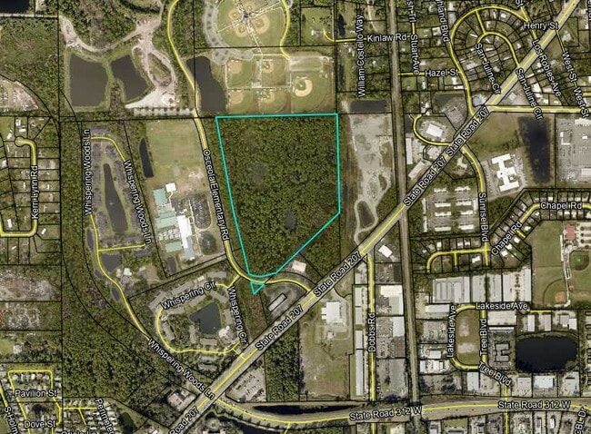

Property Detail
Osceola Elementary Rd
Jacksonville, FL
7-2 PT OF NW1/4 LYING N OF SR 207 & W OF FPL EASE (EX PT OF RD TO SJC IN OR1425/123) OR5667/1871
098420-0020
ST. JOHNS
Commercialacreage
Florida
OR
7-2
B and X Area of moderate flood hazard, usually the area between the limits of the 100-year and 500-year floods.
30.66 AC
2025
St Johns County
2026
Jacksonville (Florida)
020300
NEARBY LISTINGS FOR SALE OR LEASE
DEMOGRAPHICS near Osceola Elementary Rd
1 mile
3 mile
5 mile
2025 Total Population
5,043
44,153
87,705
2030 Population
5,867
51,406
102,220
Pop Growth 2025-2030
+ 16.34%
+ 16.43%
+ 16.55%
Average Age
41
44
46
2025 Total Households
2,104
18,770
38,093
HH Growth 2025-2030
+ 16.73%
+ 16.90%
+ 16.98%
Median Household Inc
$58,477
$72,963
$77,316
Avg Household Size
2.30
2.20
2.20
2025 Avg HH Vehicles
2.00
2.00
2.00
Median Home Value
$253,266
$392,553
$435,925
Median Year Built
1998
1996
1997
Nearby Places
Map Layers
Map Styles
 Street
 Aerial
Layers
 Traffic
 Biking
Places
Listings with unknown addresses are not visible on the map
- Restaurants
- Banks
- Shops
- Fitness
- Groceries
Nearby Properties
Address
Land Use
TOTAL SIZE
Lot Size
Zoning
Address
Land Use
TOTAL SIZE
Lot Size
Zoning
322,553 SF
10.54 AC
Address
Land Use
TOTAL SIZE
Lot Size
Zoning
117,686 SF
14.52 AC
CI
Address
Land Use
TOTAL SIZE
Lot Size
Zoning
323,748 SF
4.62 AC
Address
Land Use
TOTAL SIZE
Lot Size
Zoning
532,530 SF
25.80 AC
CG
Address
Land Use
TOTAL SIZE
Lot Size
Zoning
438,417 SF
3.98 AC
Address
Land Use
TOTAL SIZE
Lot Size
Zoning
274,007 SF
22.11 AC
Address
Land Use
TOTAL SIZE
Lot Size
Zoning
209,356 SF
12.88 AC
RG-O
Address
Land Use
TOTAL SIZE
Lot Size
Zoning
311,794 SF
39.89 AC
Address
Land Use
TOTAL SIZE
Lot Size
Zoning
320,571 SF
15.91 AC
Address
Land Use
TOTAL SIZE
Lot Size
Zoning
44,656 SF
16.56 AC
Address
Land Use
TOTAL SIZE
Lot Size
Zoning
262,617 SF
37.08 AC
PUD
Address
Land Use
TOTAL SIZE
Lot Size
Zoning
Address
Land Use
TOTAL SIZE
Lot Size
Zoning
100,199 SF
1.56 AC
Address
Land Use
TOTAL SIZE
Lot Size
Zoning
53,451 SF
1.23 AC
CM2
Address
Land Use
TOTAL SIZE
Lot Size
Zoning
76,020 SF
2.22 AC
CM2
Address
Land Use
TOTAL SIZE
Lot Size
Zoning
130,186 SF
21.74 AC
CG
Address
Land Use
TOTAL SIZE
Lot Size
Zoning
115,134 SF
4.54 AC
Address
Land Use
TOTAL SIZE
Lot Size
Zoning
117,811 SF
1.17 AC
HP4
Address
Land Use
TOTAL SIZE
Lot Size
Zoning
53,172 SF
2.65 AC
Address
Land Use
TOTAL SIZE
Lot Size
Zoning
167,306 SF
17.02 AC
CG
Address
Land Use
TOTAL SIZE
Lot Size
Zoning
138,677 SF
4.08 AC
Address
Land Use
TOTAL SIZE
Lot Size
Zoning
161,211 SF
21.70 AC
PUD
Address
Land Use
TOTAL SIZE
Lot Size
Zoning
74,085 SF
2.86 AC
Address
Land Use
TOTAL SIZE
Lot Size
Zoning
119,853 SF
21.34 AC
Address
Land Use
TOTAL SIZE
Lot Size
Zoning
65,082 SF
22.11 AC
Address
Land Use
TOTAL SIZE
Lot Size
Zoning
47,385 SF
12.36 AC
Address
Land Use
TOTAL SIZE
Lot Size
Zoning
2.46 AC
CI
Address
Land Use
TOTAL SIZE
Lot Size
Zoning
Address
Land Use
TOTAL SIZE
Lot Size
Zoning
56,272 SF
1.36 AC
Address
Land Use
TOTAL SIZE
Lot Size
Zoning
1,240 SF
29.76 AC
OR
The World's #1 Commercial Real Estate Marketplace
Connect with us
© 2026 CoStar Group
The information above has been obtained from sources believed reliable. While we do not doubt its accuracy we have not verified it and make no guarantee, warranty or representation about it. It is your responsibility to independently confirm its accuracy and completeness. Any projections, opinions, assumptions, or estimates used are for example only and do not represent the current or future performance of the property. The value of this transaction to you depends on tax and other factors which should be evaluated by your tax, financial, and legal advisors. You and your advisors should conduct a careful, independent investigation of the property to determine to your satisfaction the suitability of the property for your needs.