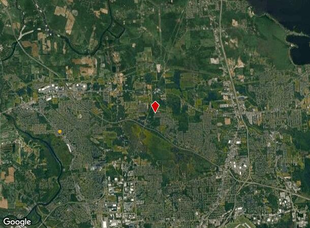
Property Record
Oswego Rd, Clay, NY 13041
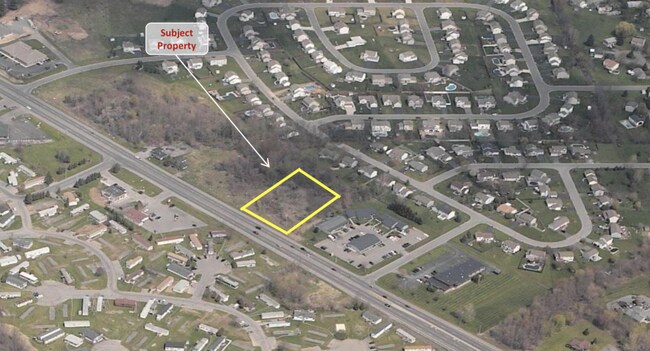
Property Detail
Oswego Rd
Syracuse, NY
FL 48 1153965
312489-067-000-0001-005-001-0000
ONONDAGA
Commercialacreage
New York
05 - COMME
5.001
B and X Area of moderate flood hazard, usually the area between the limits of the 100-year and 500-year floods.
1.87 AC
2025
NE Outer Onondaga County
2024
Syracuse
011241
NEARBY LISTINGS FOR SALE OR LEASE
DEMOGRAPHICS near Oswego Rd
1 mile
3 mile
5 mile
2025 Total Population
8,727
37,178
83,694
2030 Population
8,703
36,990
82,929
Pop Growth 2025-2030
(0.28%)
(0.51%)
(0.91%)
Average Age
41
41
42
2025 Total Households
3,323
15,188
35,369
HH Growth 2025-2030
(0.39%)
(0.62%)
(1.01%)
Median Household Inc
$92,380
$94,869
$88,545
Avg Household Size
2.50
2.40
2.30
2025 Avg HH Vehicles
2.00
2.00
2.00
Median Home Value
$205,919
$224,866
$213,807
Median Year Built
1984
1980
1977
Nearby Places
Map Layers
Map Styles
 Street
 Aerial
Layers
 Traffic
 Biking
Places
Listings with unknown addresses are not visible on the map
- Restaurants
- Banks
- Shops
- Fitness
- Groceries
PUBLIC TRANSPORTATION
AIRPORT
Syracuse Hancock International
Drive
Walk
Distance
Syracuse Hancock International
17 min
10.4 mi
Freight Ports
Albany, NY Port
Drive
Walk
Distance
Albany, NY Port
181 min
150.7 mi
SALE & LEASE HISTORY
LISTING DATE
SALE/LEASE

Sep 17, 2018
For Sale
Nearby Properties
Address
Land Use
TOTAL SIZE
Lot Size
Zoning
Address
Land Use
TOTAL SIZE
Lot Size
Zoning
8,417 SF
13.95 AC
Address
Land Use
TOTAL SIZE
Lot Size
Zoning
125,400 SF
18.11 AC
GC
Address
Land Use
TOTAL SIZE
Lot Size
Zoning
66,538 SF
18.24 AC
Address
Land Use
TOTAL SIZE
Lot Size
Zoning
42,698 SF
13.85 AC
Address
Land Use
TOTAL SIZE
Lot Size
Zoning
271,263 SF
77.30 AC
Address
Land Use
TOTAL SIZE
Lot Size
Zoning
17,436 SF
98.89 AC
06000
Address
Land Use
TOTAL SIZE
Lot Size
Zoning
16,630 SF
10.16 AC
Address
Land Use
TOTAL SIZE
Lot Size
Zoning
43,968 SF
1.95 AC
Address
Land Use
TOTAL SIZE
Lot Size
Zoning
12,220 SF
5.86 AC
Address
Land Use
TOTAL SIZE
Lot Size
Zoning
7,416 SF
7.30 AC
Address
Land Use
TOTAL SIZE
Lot Size
Zoning
116,020 SF
15.72 AC
PUD
Address
Land Use
TOTAL SIZE
Lot Size
Zoning
8,114 SF
2.79 AC
Address
Land Use
TOTAL SIZE
Lot Size
Zoning
309,390 SF
68.49 AC
05 - COMME
Address
Land Use
TOTAL SIZE
Lot Size
Zoning
42,210 SF
62.23 AC
N00
Address
Land Use
TOTAL SIZE
Lot Size
Zoning
26,445 SF
3.95 AC
Address
Land Use
TOTAL SIZE
Lot Size
Zoning
8,025 SF
1.48 AC
Address
Land Use
TOTAL SIZE
Lot Size
Zoning
952 SF
3.81 AC
Address
Land Use
TOTAL SIZE
Lot Size
Zoning
16,630 SF
2.66 AC
Address
Land Use
TOTAL SIZE
Lot Size
Zoning
16,630 SF
3.95 AC
Address
Land Use
TOTAL SIZE
Lot Size
Zoning
32,370 SF
3.16 AC
Address
Land Use
TOTAL SIZE
Lot Size
Zoning
19,200 SF
4.52 AC
Address
Land Use
TOTAL SIZE
Lot Size
Zoning
39,055 SF
28.38 AC
Address
Land Use
TOTAL SIZE
Lot Size
Zoning
11,571 SF
1.53 AC
Address
Land Use
TOTAL SIZE
Lot Size
Zoning
22,344 SF
9.94 AC
Address
Land Use
TOTAL SIZE
Lot Size
Zoning
19,740 SF
0.01 AC
Address
Land Use
TOTAL SIZE
Lot Size
Zoning
17,760 SF
4.54 AC
CG
Address
Land Use
TOTAL SIZE
Lot Size
Zoning
3,600 SF
2.13 AC
Address
Land Use
TOTAL SIZE
Lot Size
Zoning
23,015 SF
3.85 AC
Address
Land Use
TOTAL SIZE
Lot Size
Zoning
15,600 SF
10.48 AC
Address
Land Use
TOTAL SIZE
Lot Size
Zoning
30,971 SF
4.02 AC
CG
The World's #1 Commercial Real Estate Marketplace
Connect with us
© 2026 CoStar Group
The information above has been obtained from sources believed reliable. While we do not doubt its accuracy we have not verified it and make no guarantee, warranty or representation about it. It is your responsibility to independently confirm its accuracy and completeness. Any projections, opinions, assumptions, or estimates used are for example only and do not represent the current or future performance of the property. The value of this transaction to you depends on tax and other factors which should be evaluated by your tax, financial, and legal advisors. You and your advisors should conduct a careful, independent investigation of the property to determine to your satisfaction the suitability of the property for your needs.