Property Record
Otay Mesa Rd, San Ysidro, CA 92154

Save to a Folder
{{folder.Name}}
{{folder.ListingIds.length}} Properties
{{folder.ListingIds.length}} Property
Create a New Folder
Property Detail
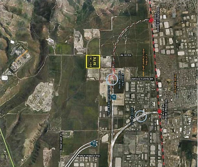
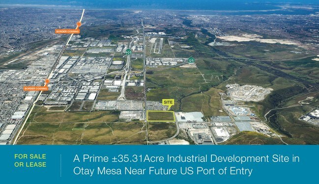
Otay Mesa Rd
648-040-13
SEC 30-18-1E SWQ (EX RDS)SEQ OF
Industrialacreage
SAN DIEGO
S88
California
B and X Area of moderate flood hazard, usually the area between the limits of the 100-year and 500-year floods.
35.22 AC
2025
Outlying SD County S
2026
San Diego
010011
San Diego-Chula Vista-Carlsbad, CA
NEARBY LISTINGS FOR SALE OR LEASE
DEMOGRAPHICS near Otay Mesa Rd
1 mile
3 mile
5 mile
2025 Total Population
237
3,800
42,339
2030 Population
237
3,797
43,146
Pop Growth 2025-2030
0.00%
(0.08%)
+ 1.91%
Average Age
49
48
36
2025 Total Households
0
9
11,049
HH Growth 2025-2030
0.00%
0.00%
+ 2.16%
Median Household Inc
$0
$112,500
$144,848
Avg Household Size
.00
3.10
3.40
2025 Avg HH Vehicles
.00
2.00
2.00
Median Home Value
$0
$812,499
$786,491
Median Year Built
0
1994
2008
Nearby Places
Map Layers
Map Styles
 Street
 Aerial
Layers
 Traffic
 Biking
Places
Listings with unknown addresses are not visible on the map
- Restaurants
- Banks
- Shops
- Fitness
- Groceries
PUBLIC TRANSPORTATION
AIRPORT
San Diego International
Drive
Walk
Distance
San Diego International
32 min
25.4 mi
Freight Ports
Port of San Diego
Drive
Walk
Distance
Port of San Diego
28 min
21.4 mi
SALE & LEASE HISTORY
LISTING DATE
SALE/LEASE

May 09, 2017
For Lease
Mar 30, 2017
For Lease
Dec 13, 2016
For Sale
Apr 26, 2017
For Sale
Nearby Properties
Address
Land Use
TOTAL SIZE
Lot Size
Zoning
Address
Land Use
TOTAL SIZE
Lot Size
Zoning
9,999 SF
62.59 AC
S88
Address
Land Use
TOTAL SIZE
Lot Size
Zoning
9,999 SF
36.96 AC
S88
Address
Land Use
TOTAL SIZE
Lot Size
Zoning
9,999 SF
62.17 AC
S88
Address
Land Use
TOTAL SIZE
Lot Size
Zoning
9,999 SF
36.27 AC
S88
Address
Land Use
TOTAL SIZE
Lot Size
Zoning
9,999 SF
31.01 AC
IBT-1-1
Address
Land Use
TOTAL SIZE
Lot Size
Zoning
9,999 SF
18.87 AC
IL-2-1
Address
Land Use
TOTAL SIZE
Lot Size
Zoning
9,999 SF
18.11 AC
IL-2-1
Address
Land Use
TOTAL SIZE
Lot Size
Zoning
9,999 SF
2.69 AC
IBT-1-1
Address
Land Use
TOTAL SIZE
Lot Size
Zoning
9,999 SF
11.91 AC
IBT-1-1
Address
Land Use
TOTAL SIZE
Lot Size
Zoning
9,999 SF
2.83 AC
IBT-1-1
Address
Land Use
TOTAL SIZE
Lot Size
Zoning
9,999 SF
11.10 AC
S88
Address
Land Use
TOTAL SIZE
Lot Size
Zoning
9,999 SF
12.72 AC
IBT-1-1
Address
Land Use
TOTAL SIZE
Lot Size
Zoning
9,999 SF
10.02 AC
IL-2-1
Address
Land Use
TOTAL SIZE
Lot Size
Zoning
9,999 SF
12.68 AC
S88
Address
Land Use
TOTAL SIZE
Lot Size
Zoning
9,999 SF
9.31 AC
IL-2-1
Address
Land Use
TOTAL SIZE
Lot Size
Zoning
9,999 SF
13.55 AC
IL-3-1
Address
Land Use
TOTAL SIZE
Lot Size
Zoning
9,999 SF
4.14 AC
IL-2-1
Address
Land Use
TOTAL SIZE
Lot Size
Zoning
9,999 SF
8.59 AC
IP-1-1
Address
Land Use
TOTAL SIZE
Lot Size
Zoning
9,999 SF
16.12 AC
S88
Address
Land Use
TOTAL SIZE
Lot Size
Zoning
9,999 SF
15.29 AC
IL-3-1
Address
Land Use
TOTAL SIZE
Lot Size
Zoning
9,999 SF
13.51 AC
S88
Address
Land Use
TOTAL SIZE
Lot Size
Zoning
9,999 SF
11.42 AC
IL-3-1
Address
Land Use
TOTAL SIZE
Lot Size
Zoning
9,999 SF
14.68 AC
IBT-1-1
Address
Land Use
TOTAL SIZE
Lot Size
Zoning
9,999 SF
4.84 AC
IBT-1-1
Address
Land Use
TOTAL SIZE
Lot Size
Zoning
9,999 SF
10.93 AC
S88
Address
Land Use
TOTAL SIZE
Lot Size
Zoning
9,999 SF
16.20 AC
S88
Address
Land Use
TOTAL SIZE
Lot Size
Zoning
14.08 AC
IL-2-1
Address
Land Use
TOTAL SIZE
Lot Size
Zoning
16.07 AC
S88
Address
Land Use
TOTAL SIZE
Lot Size
Zoning
9,999 SF
3.49 AC
IBT-1-1
Address
Land Use
TOTAL SIZE
Lot Size
Zoning
9,999 SF
3.58 AC
IBT-1-1
The World's #1 Commercial Real Estate Marketplace
Connect with us
© 2026 CoStar Group
The information above has been obtained from sources believed reliable. While we do not doubt its accuracy we have not verified it and make no guarantee, warranty or representation about it. It is your responsibility to independently confirm its accuracy and completeness. Any projections, opinions, assumptions, or estimates used are for example only and do not represent the current or future performance of the property. The value of this transaction to you depends on tax and other factors which should be evaluated by your tax, financial, and legal advisors. You and your advisors should conduct a careful, independent investigation of the property to determine to your satisfaction the suitability of the property for your needs.