Property Record
Outer Highway 10, Yucaipa, CA 92399

Property Detail
Outer Highway 10
Riverside-San Bernardino-Ontario, CA
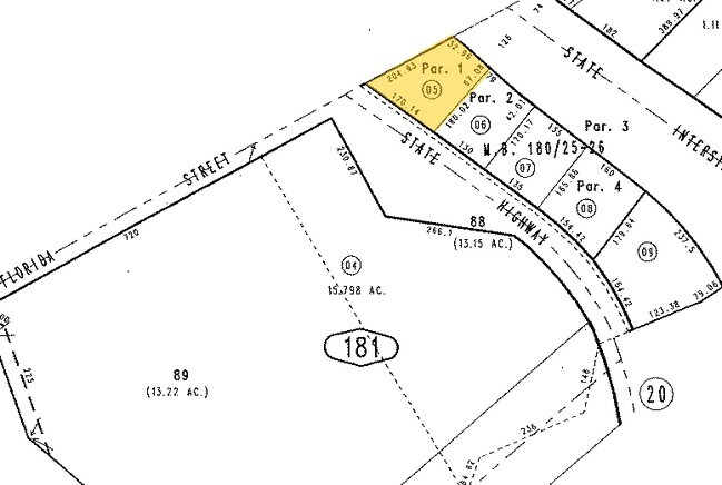
PARCEL MAP 11608 PARCEL 1 BOOK 180 PAGE 25
0301-181-06
SAN BERNARDINO
Vehiclerentalsvehiclesales
California
B and X Area of moderate flood hazard, usually the area between the limits of the 100-year and 500-year floods.
0.50 AC
2025
Redlands/Loma Linda
2025
Inland Empire (California)
008800
NEARBY LISTINGS FOR SALE OR LEASE
DEMOGRAPHICS near Outer Highway 10
1 mile
3 mile
5 mile
2025 Total Population
3,973
31,194
107,152
2030 Population
4,031
31,741
108,935
Pop Growth 2025-2030
+ 1.46%
+ 1.75%
+ 1.66%
Average Age
38
40
40
2025 Total Households
1,390
11,012
38,118
HH Growth 2025-2030
+ 1.44%
+ 1.76%
+ 1.66%
Median Household Inc
$86,891
$93,341
$100,287
Avg Household Size
2.80
2.80
2.70
2025 Avg HH Vehicles
2.00
2.00
2.00
Median Home Value
$448,290
$551,314
$590,759
Median Year Built
1971
1977
1977
Nearby Places
Map Layers
Map Styles
 Street
 Aerial
Layers
 Traffic
 Biking
Places
Listings with unknown addresses are not visible on the map
- Restaurants
- Banks
- Shops
- Fitness
- Groceries
PUBLIC TRANSPORTATION
COMMUTER RAIL
Drive
Walk
Distance
9 min
5.8 mi
Drive
Walk
Distance
10 min
6.9 mi
AIRPORT
Ontario International
Drive
Walk
Distance
Ontario International
41 min
32.3 mi
Palm Springs International
Drive
Walk
Distance
Palm Springs International
48 min
41.8 mi
SALE & LEASE HISTORY
LISTING DATE
SALE/LEASE

Jul 06, 2020
For Lease
Nearby Properties
Address
Land Use
TOTAL SIZE
Lot Size
Zoning
Address
Land Use
TOTAL SIZE
Lot Size
Zoning
369,838 SF
19.32 AC
Address
Land Use
TOTAL SIZE
Lot Size
Zoning
102,506 SF
4.47 AC
Address
Land Use
TOTAL SIZE
Lot Size
Zoning
82,694 SF
3.41 AC
Address
Land Use
TOTAL SIZE
Lot Size
Zoning
5.47 AC
Address
Land Use
TOTAL SIZE
Lot Size
Zoning
79,299 SF
5.04 AC
Address
Land Use
TOTAL SIZE
Lot Size
Zoning
67,686 SF
4.16 AC
Address
Land Use
TOTAL SIZE
Lot Size
Zoning
56,491 SF
7.50 AC
Address
Land Use
TOTAL SIZE
Lot Size
Zoning
123,855 SF
9.99 AC
Address
Land Use
TOTAL SIZE
Lot Size
Zoning
56,491 SF
3.39 AC
Address
Land Use
TOTAL SIZE
Lot Size
Zoning
49,320 SF
1.68 AC
Address
Land Use
TOTAL SIZE
Lot Size
Zoning
49,952 SF
4.34 AC
Address
Land Use
TOTAL SIZE
Lot Size
Zoning
29,387 SF
3.21 AC
Address
Land Use
TOTAL SIZE
Lot Size
Zoning
27,627 SF
5.07 AC
Address
Land Use
TOTAL SIZE
Lot Size
Zoning
111,182 SF
3.11 AC
Address
Land Use
TOTAL SIZE
Lot Size
Zoning
33,000 SF
2.96 AC
Address
Land Use
TOTAL SIZE
Lot Size
Zoning
41,005 SF
3.27 AC
MIX
Address
Land Use
TOTAL SIZE
Lot Size
Zoning
78,309 SF
7.09 AC
Address
Land Use
TOTAL SIZE
Lot Size
Zoning
122,250 SF
4.92 AC
Address
Land Use
TOTAL SIZE
Lot Size
Zoning
29,996 SF
1.86 AC
Address
Land Use
TOTAL SIZE
Lot Size
Zoning
73,670 SF
4.49 AC
Address
Land Use
TOTAL SIZE
Lot Size
Zoning
1,970 SF
6.27 AC
Address
Land Use
TOTAL SIZE
Lot Size
Zoning
23,227 SF
1.81 AC
Address
Land Use
TOTAL SIZE
Lot Size
Zoning
18,800 SF
4.07 AC
CC
Address
Land Use
TOTAL SIZE
Lot Size
Zoning
27.20 AC
Address
Land Use
TOTAL SIZE
Lot Size
Zoning
14,738 SF
1.49 AC
C1
Address
Land Use
TOTAL SIZE
Lot Size
Zoning
44,864 SF
5.34 AC
Address
Land Use
TOTAL SIZE
Lot Size
Zoning
50,936 SF
6.50 AC
936
The World's #1 Commercial Real Estate Marketplace
Connect with us
© 2026 CoStar Group
The information above has been obtained from sources believed reliable. While we do not doubt its accuracy we have not verified it and make no guarantee, warranty or representation about it. It is your responsibility to independently confirm its accuracy and completeness. Any projections, opinions, assumptions, or estimates used are for example only and do not represent the current or future performance of the property. The value of this transaction to you depends on tax and other factors which should be evaluated by your tax, financial, and legal advisors. You and your advisors should conduct a careful, independent investigation of the property to determine to your satisfaction the suitability of the property for your needs.