Property Record
Paalaa Uka Pupukea Rd, Wahiawa, HI 96786

NEARBY LISTINGS FOR SALE OR LEASE
Property Detail
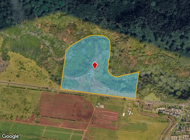
Paalaa Uka Pupukea Rd
Urban Honolulu, HI
LOT 2-F POR RP 4475, LCAW 7713:34 37.085 AC
1-6-4-004-012-0000
Honolulu
Agriculturalland
Hawaii
D
2-f
15003C0120F
37.09 AC
0
North Shore
2025
Hawaii
009401
DEMOGRAPHICS near Paalaa Uka Pupukea Rd
1 Mile
3 Mile
5 Mile
2024 Total Population
0
3,057
37,493
2029 Population
0
2,984
36,599
Pop Growth 2024-2029
0.00%
(2.39%)
(2.38%)
Average Age
0
28
36
2024 Total Households
0
945
10,852
HH Growth 2024-2029
0.00%
(3.28%)
(2.91%)
Median Household Inc
$0
$71,036
$77,683
Avg Household Size
.00
3.00
3.10
2024 Avg HH Vehicles
.00
2.00
2.00
Median Home Value
$0
$699,074
$708,349
Median Year Built
0
1991
1974
Nearby Places
Map Layers
Map Styles
 Street
 Aerial
- Restaurants
- Banks
- Shops
- Fitness
- Groceries
PUBLIC TRANSPORTATION
AIRPORT
Daniel K Inouye International
DRIVE
WALK
Distance
Daniel K Inouye International
34 min
21.3 mi
Freight Ports
Honolulu Harbor, Oahu
DRIVE
WALK
Distance
Honolulu Harbor, Oahu
43 min
25.5 mi
SALE & LEASE HISTORY
LISTING DATE
SALE/LEASE

Mar 07, 2018
For Sale
Jun 22, 2023
For Sale
Nearby Properties
Address
Land Use
TOTAL SIZE
Lot Size
Zoning
Address
Land Use
TOTAL SIZE
Lot Size
Zoning
1,930.25 AC
AG-1
Address
Land Use
TOTAL SIZE
Lot Size
Zoning
684.89 AC
F-1
Address
Land Use
TOTAL SIZE
Lot Size
Zoning
1,247.70 AC
AG-1
Address
Land Use
TOTAL SIZE
Lot Size
Zoning
263.30 AC
AG-1
Address
Land Use
TOTAL SIZE
Lot Size
Zoning
24,292 SF
17.93 AC
AG-2
Address
Land Use
TOTAL SIZE
Lot Size
Zoning
186.16 AC
AG-1
Address
Land Use
TOTAL SIZE
Lot Size
Zoning
467.64 AC
AG-1
Address
Land Use
TOTAL SIZE
Lot Size
Zoning
281.41 AC
F-1
Address
Land Use
TOTAL SIZE
Lot Size
Zoning
480.24 AC
AG-1
Address
Land Use
TOTAL SIZE
Lot Size
Zoning
4 AC
I-2
Address
Land Use
TOTAL SIZE
Lot Size
Zoning
310.86 AC
AG-1
Address
Land Use
TOTAL SIZE
Lot Size
Zoning
40,614 SF
36.33 AC
AG-1
Address
Land Use
TOTAL SIZE
Lot Size
Zoning
55,637 SF
3.73 AC
I-2
Address
Land Use
TOTAL SIZE
Lot Size
Zoning
29,931 SF
14.29 AC
AG-1
Address
Land Use
TOTAL SIZE
Lot Size
Zoning
0.80 AC
I-2
Address
Land Use
TOTAL SIZE
Lot Size
Zoning
27,338 SF
10 AC
AG-1
Address
Land Use
TOTAL SIZE
Lot Size
Zoning
83.33 AC
AG-1
Address
Land Use
TOTAL SIZE
Lot Size
Zoning
14,476 SF
0.69 AC
B-2
Address
Land Use
TOTAL SIZE
Lot Size
Zoning
55,378 SF
2,636.82 AC
AG-1
Address
Land Use
TOTAL SIZE
Lot Size
Zoning
145.15 AC
AG-1
Address
Land Use
TOTAL SIZE
Lot Size
Zoning
10,968 SF
0.92 AC
B-2
Address
Land Use
TOTAL SIZE
Lot Size
Zoning
31,960 SF
24.09 AC
AG-1
Address
Land Use
TOTAL SIZE
Lot Size
Zoning
27,144 SF
0.80 AC
I-2
Address
Land Use
TOTAL SIZE
Lot Size
Zoning
25,948 SF
0.46 AC
B-2
Address
Land Use
TOTAL SIZE
Lot Size
Zoning
3,385.66 AC
AG-1
Address
Land Use
TOTAL SIZE
Lot Size
Zoning
13,975 SF
0.88 AC
I-2
Address
Land Use
TOTAL SIZE
Lot Size
Zoning
8,660 SF
0.47 AC
B-2
Address
Land Use
TOTAL SIZE
Lot Size
Zoning
22,288 SF
3.02 AC
AG-1
Address
Land Use
TOTAL SIZE
Lot Size
Zoning
3,640 SF
0.67 AC
B-2
Address
Land Use
TOTAL SIZE
Lot Size
Zoning
57.78 AC
AG-1
The World's #1 Commercial Real Estate Marketplace
Connect with us
© 2025 CoStar Group
The information above has been obtained from sources believed reliable. While we do not doubt its accuracy we have not verified it and make no guarantee, warranty or representation about it. It is your responsibility to independently confirm its accuracy and completeness. Any projections, opinions, assumptions, or estimates used are for example only and do not represent the current or future performance of the property. The value of this transaction to you depends on tax and other factors which should be evaluated by your tax, financial, and legal advisors. You and your advisors should conduct a careful, independent investigation of the property to determine to your satisfaction the suitability of the property for your needs.