Property Record
Pack Rd, Ranger, GA 30734

Save to a Folder
{{folder.Name}}
{{folder.ListingIds.length}} Properties
{{folder.ListingIds.length}} Property
Create a New Folder
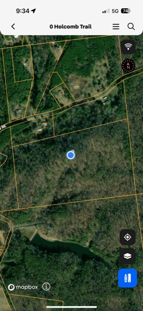
Property Detail
Pack Rd
106-093
GORDON
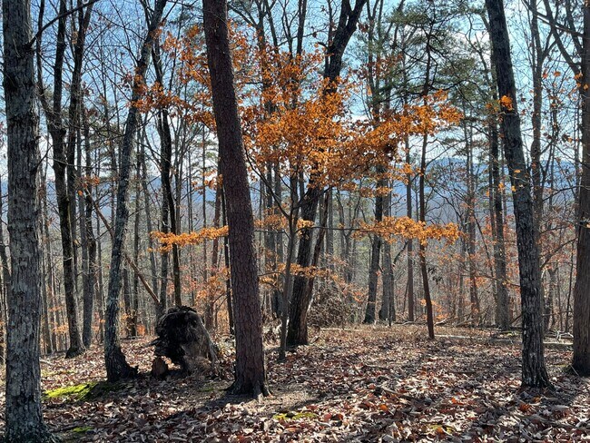
Agriculturalland
Georgia
A-1
26.14 AC
A Areas with a 1% annual chance of flooding and a 26% chance of flooding over the life of a 30-year mortgage.
Georgia Northwest
2025
Other Market Areas
2025
Calhoun, GA
970102
NEARBY LISTINGS FOR SALE OR LEASE
-
-
View all Ranger listings for sale on LoopNet.com
DEMOGRAPHICS near Pack Rd
1 mile
3 mile
5 mile
2025 Total Population
203
1,492
3,586
2030 Population
214
1,576
3,784
Pop Growth 2025-2030
+ 5.42%
+ 5.63%
+ 5.52%
Average Age
44
44
43
2025 Total Households
80
586
1,387
HH Growth 2025-2030
+ 6.25%
+ 5.63%
+ 5.48%
Median Household Inc
$55,000
$54,607
$56,754
Avg Household Size
2.60
2.50
2.60
2025 Avg HH Vehicles
2.00
2.00
2.00
Median Home Value
$325,714
$325,000
$321,901
Median Year Built
1991
1992
1991
Nearby Places
Map Layers
Map Styles
 Street
 Aerial
Layers
 Traffic
 Biking
Places
Listings with unknown addresses are not visible on the map
- Restaurants
- Banks
- Shops
- Fitness
- Groceries
SALE & LEASE HISTORY
LISTING DATE
SALE/LEASE

Sep 14, 2023
For Sale
Nearby Properties
Address
Land Use
TOTAL SIZE
Lot Size
Zoning
Address
Land Use
TOTAL SIZE
Lot Size
Zoning
99.48 AC
CU
Address
Land Use
TOTAL SIZE
Lot Size
Zoning
2,438 AC
A-1
Address
Land Use
TOTAL SIZE
Lot Size
Zoning
21.60 AC
A-1
Address
Land Use
TOTAL SIZE
Lot Size
Zoning
634.32 AC
A-1
Address
Land Use
TOTAL SIZE
Lot Size
Zoning
31,700 SF
21.53 AC
A-1
Address
Land Use
TOTAL SIZE
Lot Size
Zoning
1,118.60 AC
A-1
Address
Land Use
TOTAL SIZE
Lot Size
Zoning
928 SF
57.54 AC
A-1
Address
Land Use
TOTAL SIZE
Lot Size
Zoning
9,264 SF
2.94 AC
A-1
Address
Land Use
TOTAL SIZE
Lot Size
Zoning
1,008 SF
718.86 AC
A-1
Address
Land Use
TOTAL SIZE
Lot Size
Zoning
3,200 SF
3.22 AC
CU
Address
Land Use
TOTAL SIZE
Lot Size
Zoning
3,904 SF
1.20 AC
Address
Land Use
TOTAL SIZE
Lot Size
Zoning
36,960 SF
5.57 AC
A-1
Address
Land Use
TOTAL SIZE
Lot Size
Zoning
9,100 SF
3.66 AC
Address
Land Use
TOTAL SIZE
Lot Size
Zoning
215.61 AC
A-1
Address
Land Use
TOTAL SIZE
Lot Size
Zoning
299.94 AC
A-1
Address
Land Use
TOTAL SIZE
Lot Size
Zoning
2,306 SF
1 AC
A-1
Address
Land Use
TOTAL SIZE
Lot Size
Zoning
928 SF
151 AC
A-1
Address
Land Use
TOTAL SIZE
Lot Size
Zoning
399.70 AC
A-1
Address
Land Use
TOTAL SIZE
Lot Size
Zoning
5.06 AC
A-1
Address
Land Use
TOTAL SIZE
Lot Size
Zoning
227.48 AC
Address
Land Use
TOTAL SIZE
Lot Size
Zoning
207 AC
A-1
Address
Land Use
TOTAL SIZE
Lot Size
Zoning
3,807 SF
2.43 AC
Address
Land Use
TOTAL SIZE
Lot Size
Zoning
46.72 AC
AG
Address
Land Use
TOTAL SIZE
Lot Size
Zoning
306.25 AC
A-1
Address
Land Use
TOTAL SIZE
Lot Size
Zoning
1,536 SF
1.30 AC
A-1
Address
Land Use
TOTAL SIZE
Lot Size
Zoning
3,807 SF
2.43 AC
Address
Land Use
TOTAL SIZE
Lot Size
Zoning
3,588 SF
0.79 AC
A-1
Address
Land Use
TOTAL SIZE
Lot Size
Zoning
283 AC
A-1
Address
Land Use
TOTAL SIZE
Lot Size
Zoning
158.84 AC
A-1
Address
Land Use
TOTAL SIZE
Lot Size
Zoning
98.04 AC
A-1
The World's #1 Commercial Real Estate Marketplace
Connect with us
© 2026 CoStar Group
The information above has been obtained from sources believed reliable. While we do not doubt its accuracy we have not verified it and make no guarantee, warranty or representation about it. It is your responsibility to independently confirm its accuracy and completeness. Any projections, opinions, assumptions, or estimates used are for example only and do not represent the current or future performance of the property. The value of this transaction to you depends on tax and other factors which should be evaluated by your tax, financial, and legal advisors. You and your advisors should conduct a careful, independent investigation of the property to determine to your satisfaction the suitability of the property for your needs.