Property Record
Pan Ave, , WV

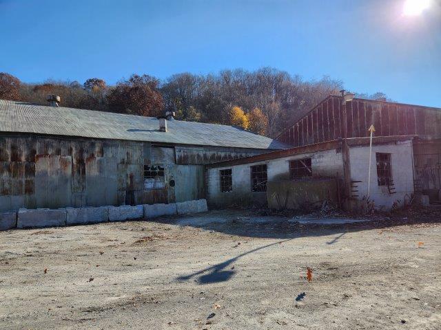

Property Detail
Pan Ave
Weirton-Steubenville, WV-OH
LOT 248 S S L CO ADN
02-CH3M-00040000
HANCOCK
Commercialacreage
West Virginia
B and X Area of moderate flood hazard, usually the area between the limits of the 100-year and 500-year floods.
248
2025
15.10 AC
2025
West Virginia North Area
021500
Other Market Areas
NEARBY LISTINGS FOR SALE OR LEASE
-
-
View all listings for sale on LoopNet.com
DEMOGRAPHICS near Pan Ave
1 mile
3 mile
5 mile
2025 Total Population
4,295
19,598
30,737
2030 Population
4,265
19,565
30,610
Pop Growth 2025-2030
(0.70%)
(0.17%)
(0.41%)
Average Age
42
43
43
2025 Total Households
1,812
8,449
13,265
HH Growth 2025-2030
(0.83%)
(0.20%)
(0.43%)
Median Household Inc
$44,847
$43,944
$49,366
Avg Household Size
2.30
2.30
2.30
2025 Avg HH Vehicles
1.00
2.00
2.00
Median Home Value
$85,772
$97,745
$126,374
Median Year Built
1947
1952
1957
Nearby Places
Map Layers
Map Styles
 Street
 Aerial
Transit
 Traffic
 Biking
Places
Listings with unknown addresses are not visible on the map
- Restaurants
- Banks
- Shops
- Fitness
- Groceries
PUBLIC TRANSPORTATION
AIRPORT
Pittsburgh International
Drive
Walk
Distance
Pittsburgh International
47 min
26.1 mi
Freight Ports
Port of Toledo
Drive
Walk
Distance
Port of Toledo
237 min
207.4 mi
SALE & LEASE HISTORY
LISTING DATE
SALE/LEASE

Dec 27, 2023
For Sale
Apr 10, 2019
For Sale
Nearby Properties
Address
Land Use
TOTAL SIZE
Lot Size
Zoning
Address
Land Use
TOTAL SIZE
Lot Size
Zoning
157,837 SF
1.67 AC
Address
Land Use
TOTAL SIZE
Lot Size
Zoning
108,681 SF
33.42 AC
Address
Land Use
TOTAL SIZE
Lot Size
Zoning
28.75 AC
Address
Land Use
TOTAL SIZE
Lot Size
Zoning
14.55 AC
Address
Land Use
TOTAL SIZE
Lot Size
Zoning
75.64 AC
Address
Land Use
TOTAL SIZE
Lot Size
Zoning
2.76 AC
Address
Land Use
TOTAL SIZE
Lot Size
Zoning
25.06 AC
Address
Land Use
TOTAL SIZE
Lot Size
Zoning
66,898 SF
16 AC
Address
Land Use
TOTAL SIZE
Lot Size
Zoning
1.13 AC
Address
Land Use
TOTAL SIZE
Lot Size
Zoning
38,140 SF
9.85 AC
Address
Land Use
TOTAL SIZE
Lot Size
Zoning
33,563 SF
5.85 AC
Address
Land Use
TOTAL SIZE
Lot Size
Zoning
3,600 SF
3.07 AC
Address
Land Use
TOTAL SIZE
Lot Size
Zoning
1,853 SF
11.62 AC
Address
Land Use
TOTAL SIZE
Lot Size
Zoning
13.59 AC
Address
Land Use
TOTAL SIZE
Lot Size
Zoning
11,800 SF
0.59 AC
Address
Land Use
TOTAL SIZE
Lot Size
Zoning
440.15 AC
Address
Land Use
TOTAL SIZE
Lot Size
Zoning
85,013 SF
2.91 AC
Address
Land Use
TOTAL SIZE
Lot Size
Zoning
7,280 SF
10.58 AC
Address
Land Use
TOTAL SIZE
Lot Size
Zoning
50,868 SF
0.50 AC
Address
Land Use
TOTAL SIZE
Lot Size
Zoning
2,400 SF
2 AC
Address
Land Use
TOTAL SIZE
Lot Size
Zoning
7.58 AC
Address
Land Use
TOTAL SIZE
Lot Size
Zoning
0.51 AC
Address
Land Use
TOTAL SIZE
Lot Size
Zoning
25,780 SF
0.13 AC
Address
Land Use
TOTAL SIZE
Lot Size
Zoning
23,519 SF
1.04 AC
Address
Land Use
TOTAL SIZE
Lot Size
Zoning
583.66 AC
Address
Land Use
TOTAL SIZE
Lot Size
Zoning
Address
Land Use
TOTAL SIZE
Lot Size
Zoning
Address
Land Use
TOTAL SIZE
Lot Size
Zoning
49,020 SF
0.33 AC
Address
Land Use
TOTAL SIZE
Lot Size
Zoning
18,004 SF
0.20 AC
The World's #1 Commercial Real Estate Marketplace
Connect with us
© 2026 CoStar Group
The information above has been obtained from sources believed reliable. While we do not doubt its accuracy we have not verified it and make no guarantee, warranty or representation about it. It is your responsibility to independently confirm its accuracy and completeness. Any projections, opinions, assumptions, or estimates used are for example only and do not represent the current or future performance of the property. The value of this transaction to you depends on tax and other factors which should be evaluated by your tax, financial, and legal advisors. You and your advisors should conduct a careful, independent investigation of the property to determine to your satisfaction the suitability of the property for your needs.