Property Record
Pandora Dr, Crestview, FL 32536

Property Detail
Pandora Dr
Crestview-Fort Walton Beach-Destin, FL
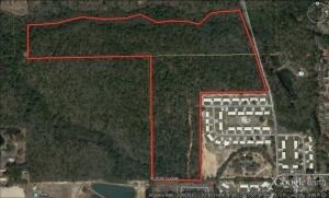
COM NE COR OF SW1/4 S 427.31FT W 86.78FT TO W R/W PANDORA DR AND POB W 700.39FT S 903.21FT W 516.8FT N 1317.88FT E 1104.57FT TO SAID W R/W S15 DEG E ALG R/W 440.67FT TO POB AKA PARCAL A AND COM NE COR SW1/4 S 427.31FT TO POB W 18.29FT TO E R/W PANDOR
07-3N-23-0000-0013-0000
OKALOOSA
Miscellaneous
Florida
B and X Area of moderate flood hazard, usually the area between the limits of the 100-year and 500-year floods.
21.17 AC
2025
Fort Walton Beach
2025
Other Market Areas
020500
NEARBY LISTINGS FOR SALE OR LEASE
DEMOGRAPHICS near Pandora Dr
1 mile
3 mile
5 mile
2025 Total Population
5,001
22,321
49,424
2030 Population
5,151
23,191
50,899
Pop Growth 2025-2030
+ 3.00%
+ 3.90%
+ 2.98%
Average Age
36
38
37
2025 Total Households
1,866
8,015
17,865
HH Growth 2025-2030
+ 2.73%
+ 3.76%
+ 2.82%
Median Household Inc
$77,876
$70,490
$81,967
Avg Household Size
2.60
2.60
2.70
2025 Avg HH Vehicles
2.00
2.00
2.00
Median Home Value
$289,121
$281,417
$315,145
Median Year Built
1998
1996
1999
Nearby Places
Map Layers
Map Styles
 Street
 Aerial
Transit
 Traffic
 Biking
Places
Listings with unknown addresses are not visible on the map
- Restaurants
- Banks
- Shops
- Fitness
- Groceries
PUBLIC TRANSPORTATION
AIRPORT
Eglin AFB/Destin-Ft Walton Beach
Drive
Walk
Distance
Eglin AFB/Destin-Ft Walton Beach
51 min
27.3 mi
Freight Ports
Port of Panama City
Drive
Walk
Distance
Port of Panama City
116 min
87.7 mi
SALE & LEASE HISTORY
LISTING DATE
SALE/LEASE

Sep 15, 2025
For Sale
Jun 13, 2017
For Sale
Nearby Properties
Address
Land Use
TOTAL SIZE
Lot Size
Zoning
Address
Land Use
TOTAL SIZE
Lot Size
Zoning
368,602 SF
29.05 AC
Address
Land Use
TOTAL SIZE
Lot Size
Zoning
143,873 SF
20.26 AC
Address
Land Use
TOTAL SIZE
Lot Size
Zoning
76,136 SF
7.45 AC
Address
Land Use
TOTAL SIZE
Lot Size
Zoning
179,054 SF
22.90 AC
Address
Land Use
TOTAL SIZE
Lot Size
Zoning
13,976 SF
19.04 AC
C-1
Address
Land Use
TOTAL SIZE
Lot Size
Zoning
297,438 SF
39.75 AC
Address
Land Use
TOTAL SIZE
Lot Size
Zoning
136,672 SF
13.63 AC
C-1
Address
Land Use
TOTAL SIZE
Lot Size
Zoning
61,672 SF
5.65 AC
Address
Land Use
TOTAL SIZE
Lot Size
Zoning
7,615 SF
70.60 AC
Address
Land Use
TOTAL SIZE
Lot Size
Zoning
80,274 SF
12.60 AC
Address
Land Use
TOTAL SIZE
Lot Size
Zoning
71,382 SF
2.55 AC
Address
Land Use
TOTAL SIZE
Lot Size
Zoning
79,992 SF
7.26 AC
Address
Land Use
TOTAL SIZE
Lot Size
Zoning
87,672 SF
15.69 AC
Address
Land Use
TOTAL SIZE
Lot Size
Zoning
128,128 SF
30.01 AC
Address
Land Use
TOTAL SIZE
Lot Size
Zoning
62,274 SF
7 AC
Address
Land Use
TOTAL SIZE
Lot Size
Zoning
51,432 SF
3.95 AC
Address
Land Use
TOTAL SIZE
Lot Size
Zoning
40,754 SF
23.67 AC
Address
Land Use
TOTAL SIZE
Lot Size
Zoning
70,918 SF
14.91 AC
Address
Land Use
TOTAL SIZE
Lot Size
Zoning
105,796 SF
6.77 AC
Address
Land Use
TOTAL SIZE
Lot Size
Zoning
210,809 SF
2.06 AC
Address
Land Use
TOTAL SIZE
Lot Size
Zoning
35,898 SF
5.26 AC
Address
Land Use
TOTAL SIZE
Lot Size
Zoning
88,248 SF
5.17 AC
Address
Land Use
TOTAL SIZE
Lot Size
Zoning
61,064 SF
4.80 AC
Address
Land Use
TOTAL SIZE
Lot Size
Zoning
73,736 SF
6.24 AC
Address
Land Use
TOTAL SIZE
Lot Size
Zoning
102,916 SF
18.06 AC
Address
Land Use
TOTAL SIZE
Lot Size
Zoning
70,068 SF
4.10 AC
Address
Land Use
TOTAL SIZE
Lot Size
Zoning
42,405 SF
14.59 AC
Address
Land Use
TOTAL SIZE
Lot Size
Zoning
55,211 SF
7.42 AC
Address
Land Use
TOTAL SIZE
Lot Size
Zoning
25,933 SF
1.12 AC
Address
Land Use
TOTAL SIZE
Lot Size
Zoning
25,472 SF
3.02 AC
The World's #1 Commercial Real Estate Marketplace
Connect with us
© 2026 CoStar Group
The information above has been obtained from sources believed reliable. While we do not doubt its accuracy we have not verified it and make no guarantee, warranty or representation about it. It is your responsibility to independently confirm its accuracy and completeness. Any projections, opinions, assumptions, or estimates used are for example only and do not represent the current or future performance of the property. The value of this transaction to you depends on tax and other factors which should be evaluated by your tax, financial, and legal advisors. You and your advisors should conduct a careful, independent investigation of the property to determine to your satisfaction the suitability of the property for your needs.