Property Record
Panthers Den Rd, Makanda, IL 62958

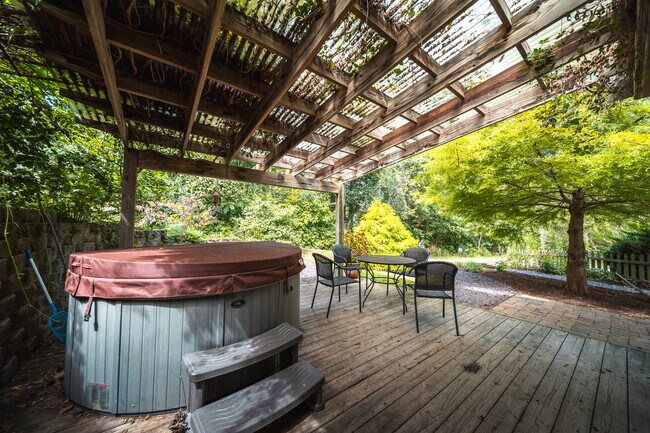
This Property Is For Sale
NEARBY LISTINGS FOR SALE OR LEASE
-
-
View all Makanda listings for sale on LoopNet.com
Property Detail
Panthers Den Rd
01-09-00-052-2
S9 T11 R1E PT S 1/2 SW SURVEY 361-738 03/26/13 PARCEL A
Residentialnec
Union
X
Illinois
17199C0300D
2.57 AC
2024
Marion/I-64 & South
2024
Other Market Areas
950100
DEMOGRAPHICS near Panthers Den Rd
1 mile
3 mile
5 mile
2024 Total Population
22
329
1,133
2029 Population
21
323
1,111
Pop Growth 2024-2029
(4.55%)
(1.82%)
(1.94%)
Average Age
48
46
45
2024 Total Households
9
139
476
HH Growth 2024-2029
0.00%
(1.44%)
(1.89%)
Median Household Inc
$87,500
$73,749
$70,999
Avg Household Size
2.00
2.30
2.30
2024 Avg HH Vehicles
2.00
2.00
2.00
Median Home Value
$125,000
$167,241
$166,980
Median Year Built
1984
1984
1986
Nearby Places
Map Layers
Map Styles
 Street
 Aerial
Transit
 Traffic
 Biking
Places
Listings with unknown addresses are not visible on the map
- Restaurants
- Banks
- Shops
- Fitness
- Groceries
Nearby Properties
Address
Land Use
TOTAL SIZE
Lot Size
Zoning
Address
Land Use
TOTAL SIZE
Lot Size
Zoning
Address
Land Use
TOTAL SIZE
Lot Size
Zoning
88.21 AC
Address
Land Use
TOTAL SIZE
Lot Size
Zoning
32.32 AC
Address
Land Use
TOTAL SIZE
Lot Size
Zoning
Address
Land Use
TOTAL SIZE
Lot Size
Zoning
Address
Land Use
TOTAL SIZE
Lot Size
Zoning
8.15 AC
Address
Land Use
TOTAL SIZE
Lot Size
Zoning
157.80 AC
Address
Land Use
TOTAL SIZE
Lot Size
Zoning
106.46 AC
Address
Land Use
TOTAL SIZE
Lot Size
Zoning
40.19 AC
Address
Land Use
TOTAL SIZE
Lot Size
Zoning
10.74 AC
Address
Land Use
TOTAL SIZE
Lot Size
Zoning
28.58 AC
Address
Land Use
TOTAL SIZE
Lot Size
Zoning
Address
Land Use
TOTAL SIZE
Lot Size
Zoning
6.42 AC
Address
Land Use
TOTAL SIZE
Lot Size
Zoning
21.08 AC
Address
Land Use
TOTAL SIZE
Lot Size
Zoning
31.08 AC
Address
Land Use
TOTAL SIZE
Lot Size
Zoning
31.08 AC
Address
Land Use
TOTAL SIZE
Lot Size
Zoning
Address
Land Use
TOTAL SIZE
Lot Size
Zoning
5.02 AC
Address
Land Use
TOTAL SIZE
Lot Size
Zoning
Address
Land Use
TOTAL SIZE
Lot Size
Zoning
22.87 AC
Address
Land Use
TOTAL SIZE
Lot Size
Zoning
90.65 AC
Address
Land Use
TOTAL SIZE
Lot Size
Zoning
21.80 AC
Address
Land Use
TOTAL SIZE
Lot Size
Zoning
50.91 AC
Address
Land Use
TOTAL SIZE
Lot Size
Zoning
35.50 AC
Address
Land Use
TOTAL SIZE
Lot Size
Zoning
Address
Land Use
TOTAL SIZE
Lot Size
Zoning
34.24 AC
Address
Land Use
TOTAL SIZE
Lot Size
Zoning
4,962 SF
0.84 AC
Address
Land Use
TOTAL SIZE
Lot Size
Zoning
40.87 AC
Address
Land Use
TOTAL SIZE
Lot Size
Zoning
Address
Land Use
TOTAL SIZE
Lot Size
Zoning
The World's #1 Commercial Real Estate Marketplace
Connect with us
© 2026 CoStar Group
The information above has been obtained from sources believed reliable. While we do not doubt its accuracy we have not verified it and make no guarantee, warranty or representation about it. It is your responsibility to independently confirm its accuracy and completeness. Any projections, opinions, assumptions, or estimates used are for example only and do not represent the current or future performance of the property. The value of this transaction to you depends on tax and other factors which should be evaluated by your tax, financial, and legal advisors. You and your advisors should conduct a careful, independent investigation of the property to determine to your satisfaction the suitability of the property for your needs.