Property Record
Park Rd, Venice, FL 34293
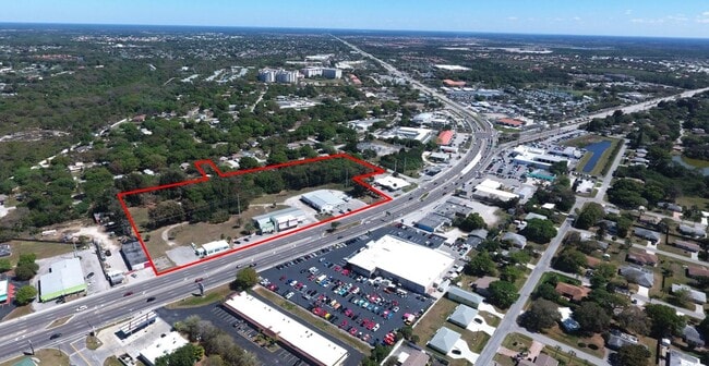
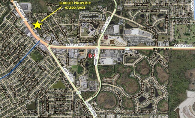

Property Detail
Park Rd
North Port-Bradenton-Sarasota, FL
LOT 24 BLK 2 VENICE GROVES
0450-07-0059
SARASOTA
Residentialacreage
Florida
RSF3
24
B and X Area of moderate flood hazard, usually the area between the limits of the 100-year and 500-year floods.
0.13 AC
2024
Sarasota Outlying
2025
Tampa/St Petersburg
002510
NEARBY LISTINGS FOR SALE OR LEASE
DEMOGRAPHICS near Park Rd
1 mile
3 mile
5 mile
2024 Total Population
8,178
44,427
95,361
2029 Population
9,295
51,099
110,864
Pop Growth 2024-2029
+ 13.66%
+ 15.02%
+ 16.26%
Average Age
49
57
59
2024 Total Households
3,788
21,792
47,877
HH Growth 2024-2029
+ 13.60%
+ 15.16%
+ 16.34%
Median Household Inc
$66,127
$68,064
$72,552
Avg Household Size
2.10
2.00
1.90
2024 Avg HH Vehicles
2.00
2.00
2.00
Median Home Value
$258,765
$289,172
$330,017
Median Year Built
1986
1986
1990
Nearby Places
Map Layers
Map Styles
 Street
 Aerial
Transit
 Traffic
 Biking
Places
Listings with unknown addresses are not visible on the map
- Restaurants
- Banks
- Shops
- Fitness
- Groceries
PUBLIC TRANSPORTATION
AIRPORT
Sarasota/Bradenton International
Drive
Walk
Distance
Sarasota/Bradenton International
48 min
34.5 mi
Punta Gorda
Drive
Walk
Distance
Punta Gorda
49 min
38.2 mi
Freight Ports
Port Manatee
Drive
Walk
Distance
Port Manatee
60 min
47.0 mi
SALE & LEASE HISTORY
LISTING DATE
SALE/LEASE

Mar 18, 2021
For Sale
Nearby Properties
Address
Land Use
TOTAL SIZE
Lot Size
Zoning
Address
Land Use
TOTAL SIZE
Lot Size
Zoning
565,625 SF
15.61 AC
ST2A
Address
Land Use
TOTAL SIZE
Lot Size
Zoning
251,872 SF
25.01 AC
RMF2
Address
Land Use
TOTAL SIZE
Lot Size
Zoning
191,373 SF
23.12 AC
RMF2
Address
Land Use
TOTAL SIZE
Lot Size
Zoning
173,966 SF
17 AC
CG
Address
Land Use
TOTAL SIZE
Lot Size
Zoning
149,834 SF
36.95 AC
GU
Address
Land Use
TOTAL SIZE
Lot Size
Zoning
223,397 SF
453.78 AC
G
Address
Land Use
TOTAL SIZE
Lot Size
Zoning
159,759 SF
12.60 AC
RMF3
Address
Land Use
TOTAL SIZE
Lot Size
Zoning
201,992 SF
22.45 AC
CG
Address
Land Use
TOTAL SIZE
Lot Size
Zoning
85,177 SF
68.01 AC
RE1
Address
Land Use
TOTAL SIZE
Lot Size
Zoning
146,990 SF
8.90 AC
CG
Address
Land Use
TOTAL SIZE
Lot Size
Zoning
98,113 SF
12.05 AC
CSC
Address
Land Use
TOTAL SIZE
Lot Size
Zoning
111,306 SF
9.35 AC
CSC
Address
Land Use
TOTAL SIZE
Lot Size
Zoning
138,547 SF
18.63 AC
CSC
Address
Land Use
TOTAL SIZE
Lot Size
Zoning
66,899 SF
30.10 AC
GU
Address
Land Use
TOTAL SIZE
Lot Size
Zoning
121,747 SF
17.54 AC
OUE1
Address
Land Use
TOTAL SIZE
Lot Size
Zoning
112,415 SF
8.77 AC
CSC
Address
Land Use
TOTAL SIZE
Lot Size
Zoning
92,802 SF
4.78 AC
CN
Address
Land Use
TOTAL SIZE
Lot Size
Zoning
3,447 SF
65.66 AC
ROS
Address
Land Use
TOTAL SIZE
Lot Size
Zoning
101,496 SF
19.08 AC
CG
Address
Land Use
TOTAL SIZE
Lot Size
Zoning
119,222 SF
12.47 AC
CG
Address
Land Use
TOTAL SIZE
Lot Size
Zoning
94,453 SF
10.11 AC
CG
Address
Land Use
TOTAL SIZE
Lot Size
Zoning
79,048 SF
6.92 AC
CI
Address
Land Use
TOTAL SIZE
Lot Size
Zoning
114,693 SF
15.16 AC
PUD
Address
Land Use
TOTAL SIZE
Lot Size
Zoning
121,850 SF
8.98 AC
CG
Address
Land Use
TOTAL SIZE
Lot Size
Zoning
61,332 SF
8.25 AC
ST2
Address
Land Use
TOTAL SIZE
Lot Size
Zoning
109,350 SF
4.17 AC
CI
Address
Land Use
TOTAL SIZE
Lot Size
Zoning
6,196 SF
13.97 AC
ST2
Address
Land Use
TOTAL SIZE
Lot Size
Zoning
90,484 SF
4.35 AC
CG
Address
Land Use
TOTAL SIZE
Lot Size
Zoning
56,899 SF
5.89 AC
OPI
Address
Land Use
TOTAL SIZE
Lot Size
Zoning
28,739 SF
4.89 AC
ST2
The World's #1 Commercial Real Estate Marketplace
Connect with us
© 2026 CoStar Group
The information above has been obtained from sources believed reliable. While we do not doubt its accuracy we have not verified it and make no guarantee, warranty or representation about it. It is your responsibility to independently confirm its accuracy and completeness. Any projections, opinions, assumptions, or estimates used are for example only and do not represent the current or future performance of the property. The value of this transaction to you depends on tax and other factors which should be evaluated by your tax, financial, and legal advisors. You and your advisors should conduct a careful, independent investigation of the property to determine to your satisfaction the suitability of the property for your needs.