Property Record
Parker St, Springfield, MA 01101
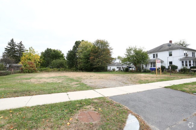

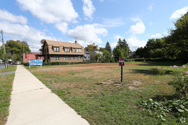

Property Detail
Parker St
SPRI-009510-000000-001964
HAMPDEN
Commercialacreage
Massachusetts
B1
0.46 AC
B and X Area of moderate flood hazard, usually the area between the limits of the 100-year and 500-year floods.
Hampden County
2025
Hartford
2025
Springfield, MA
801101
NEARBY LISTINGS FOR SALE OR LEASE
DEMOGRAPHICS near Parker St
1 mile
3 mile
5 mile
2025 Total Population
11,249
54,569
150,815
2030 Population
11,238
54,848
151,666
Pop Growth 2025-2030
(0.10%)
+ 0.51%
+ 0.56%
Average Age
39
42
41
2025 Total Households
4,601
21,294
58,552
HH Growth 2025-2030
(0.13%)
+ 0.45%
+ 0.58%
Median Household Inc
$58,408
$69,542
$68,064
Avg Household Size
2.40
2.40
2.40
2025 Avg HH Vehicles
1.00
2.00
2.00
Median Home Value
$272,975
$287,431
$279,287
Median Year Built
1950
1960
1964
Nearby Places
Map Layers
Map Styles
 Street
 Aerial
Transit
 Traffic
 Biking
Places
Listings with unknown addresses are not visible on the map
- Restaurants
- Banks
- Shops
- Fitness
- Groceries
PUBLIC TRANSPORTATION
AIRPORT
Bradley International
Drive
Walk
Distance
Bradley International
36 min
28.8 mi
Freight Ports
Port of Davisville, RI
Drive
Walk
Distance
Port of Davisville, RI
1 min
66.9 mi
SALE & LEASE HISTORY
LISTING DATE
SALE/LEASE

Sep 24, 2016
For Sale
Oct 25, 2017
For Sale
Jun 25, 2018
For Sale
Jun 19, 2018
For Sale
Jul 29, 2020
For Sale
Nearby Properties
Address
Land Use
TOTAL SIZE
Lot Size
Zoning
Address
Land Use
TOTAL SIZE
Lot Size
Zoning
89,312 SF
38.72 AC
R1
Address
Land Use
TOTAL SIZE
Lot Size
Zoning
56,576 SF
62.84 AC
SR1R4
Address
Land Use
TOTAL SIZE
Lot Size
Zoning
7.41 AC
I2
Address
Land Use
TOTAL SIZE
Lot Size
Zoning
45,444 SF
13.80 AC
Address
Land Use
TOTAL SIZE
Lot Size
Zoning
131,942 SF
40.30 AC
R1
Address
Land Use
TOTAL SIZE
Lot Size
Zoning
60.25 AC
Address
Land Use
TOTAL SIZE
Lot Size
Zoning
39,776 SF
8.16 AC
R2
Address
Land Use
TOTAL SIZE
Lot Size
Zoning
94,076 SF
63.12 AC
Address
Land Use
TOTAL SIZE
Lot Size
Zoning
105,000 SF
17.59 AC
SR1R3
Address
Land Use
TOTAL SIZE
Lot Size
Zoning
71,911 SF
9.19 AC
Address
Land Use
TOTAL SIZE
Lot Size
Zoning
762,340 SF
76.18 AC
SR1R2I
Address
Land Use
TOTAL SIZE
Lot Size
Zoning
99,792 SF
123.26 AC
S
Address
Land Use
TOTAL SIZE
Lot Size
Zoning
62,115 SF
1.69 AC
R1
Address
Land Use
TOTAL SIZE
Lot Size
Zoning
136,326 SF
65.19 AC
Address
Land Use
TOTAL SIZE
Lot Size
Zoning
15.31 AC
GB
Address
Land Use
TOTAL SIZE
Lot Size
Zoning
6.81 AC
S
Address
Land Use
TOTAL SIZE
Lot Size
Zoning
49,431 SF
6.19 AC
SR1B1
Address
Land Use
TOTAL SIZE
Lot Size
Zoning
34,732 SF
24.73 AC
R1
Address
Land Use
TOTAL SIZE
Lot Size
Zoning
3,534 SF
38.61 AC
R-3
Address
Land Use
TOTAL SIZE
Lot Size
Zoning
109,136 SF
5.01 AC
Address
Land Use
TOTAL SIZE
Lot Size
Zoning
47,458 SF
3.87 AC
R1
Address
Land Use
TOTAL SIZE
Lot Size
Zoning
139,292 SF
12.54 AC
SB1I2
Address
Land Use
TOTAL SIZE
Lot Size
Zoning
34.44 AC
I
Address
Land Use
TOTAL SIZE
Lot Size
Zoning
144,253 SF
32.19 AC
SR2B1
Address
Land Use
TOTAL SIZE
Lot Size
Zoning
13.02 AC
Address
Land Use
TOTAL SIZE
Lot Size
Zoning
42,600 SF
10.09 AC
R1
Address
Land Use
TOTAL SIZE
Lot Size
Zoning
123,200 SF
20 AC
R3
Address
Land Use
TOTAL SIZE
Lot Size
Zoning
133,600 SF
23.27 AC
R3
Address
Land Use
TOTAL SIZE
Lot Size
Zoning
116,670 SF
13 AC
GB
Address
Land Use
TOTAL SIZE
Lot Size
Zoning
199,007 SF
50.95 AC
S
The World's #1 Commercial Real Estate Marketplace
Connect with us
© 2026 CoStar Group
The information above has been obtained from sources believed reliable. While we do not doubt its accuracy we have not verified it and make no guarantee, warranty or representation about it. It is your responsibility to independently confirm its accuracy and completeness. Any projections, opinions, assumptions, or estimates used are for example only and do not represent the current or future performance of the property. The value of this transaction to you depends on tax and other factors which should be evaluated by your tax, financial, and legal advisors. You and your advisors should conduct a careful, independent investigation of the property to determine to your satisfaction the suitability of the property for your needs.