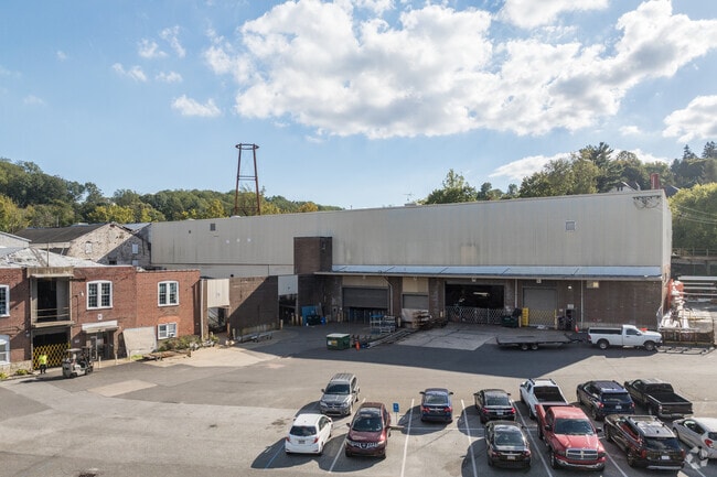
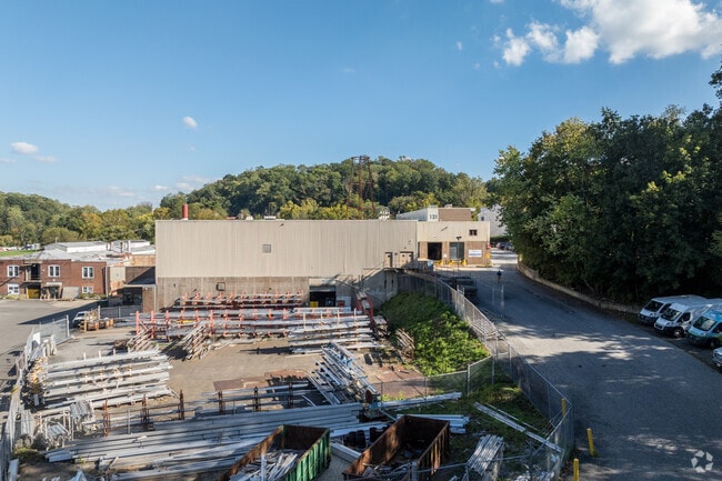
Property Record
2000 Mount Rd, Aston, PA 19014

Current Lease Availabilities
Property Detail
2000 Mount Rd
Philadelphia-Camden-Wilmington, PA-NJ-DE-MD
GRD 102 X 88 X IRR
02-00-01858-00
DELAWARE
Residentialacreage
Pennsylvania
AE The base floodplain where base flood elevations are provided. AE Zones are now used on new format FIRMs instead of A1-A30 Zones.
0.76 AC
2024
Delaware County
2025
Philadelphia
406904
NEARBY LISTINGS FOR SALE OR LEASE
DEMOGRAPHICS near 2000 Mount Rd
1 mile
3 mile
5 mile
2025 Total Population
6,575
48,217
170,426
2030 Population
6,759
48,956
173,742
Pop Growth 2025-2030
+ 2.80%
+ 1.53%
+ 1.95%
Average Age
41
44
42
2025 Total Households
2,305
18,548
66,230
HH Growth 2025-2030
+ 2.65%
+ 1.53%
+ 1.93%
Median Household Inc
$111,291
$104,855
$90,146
Avg Household Size
2.50
2.40
2.40
2025 Avg HH Vehicles
2.00
2.00
2.00
Median Home Value
$405,085
$392,361
$377,750
Median Year Built
1980
1974
1968
Nearby Places
Map Layers
Map Styles
 Street
 Aerial
Transit
 Traffic
 Biking
Places
Listings with unknown addresses are not visible on the map
- Restaurants
- Banks
- Shops
- Fitness
- Groceries
PUBLIC TRANSPORTATION
COMMUTER RAIL
Elwyn (R3 - Southeastern Pennsylvania Transportation Authority Regional Rail (SEPTA Regional Rail))
Drive
Walk
Distance
Elwyn (R3 - Southeastern Pennsylvania Transportation Authority Regional Rail (SEPTA Regional Rail))
7 min
2.5 mi
Wawa (Media/Wawa Line - SEPTA)
Drive
Walk
Distance
Wawa (Media/Wawa Line - SEPTA)
9 min
4.3 mi
AIRPORT
Philadelphia International
Drive
Walk
Distance
Philadelphia International
27 min
13.4 mi
Freight Ports
Port of Wilmington, RI
Drive
Walk
Distance
Port of Wilmington, RI
28 min
17.0 mi
Nearby Properties
Address
Land Use
TOTAL SIZE
Lot Size
Zoning
Address
Land Use
TOTAL SIZE
Lot Size
Zoning
86,400 SF
75 AC
Address
Land Use
TOTAL SIZE
Lot Size
Zoning
51,394 SF
198.04 AC
Address
Land Use
TOTAL SIZE
Lot Size
Zoning
108,030 SF
26.10 AC
Address
Land Use
TOTAL SIZE
Lot Size
Zoning
9,554 SF
69.96 AC
Address
Land Use
TOTAL SIZE
Lot Size
Zoning
38.39 AC
Address
Land Use
TOTAL SIZE
Lot Size
Zoning
2,226 SF
25.25 AC
Address
Land Use
TOTAL SIZE
Lot Size
Zoning
62,832 SF
39.05 AC
Address
Land Use
TOTAL SIZE
Lot Size
Zoning
111,606 SF
50 AC
Address
Land Use
TOTAL SIZE
Lot Size
Zoning
36.50 AC
Address
Land Use
TOTAL SIZE
Lot Size
Zoning
137,640 SF
3.67 AC
Address
Land Use
TOTAL SIZE
Lot Size
Zoning
268 AC
Address
Land Use
TOTAL SIZE
Lot Size
Zoning
241,250 SF
2 AC
Address
Land Use
TOTAL SIZE
Lot Size
Zoning
44,759 SF
5 AC
Address
Land Use
TOTAL SIZE
Lot Size
Zoning
61,536 SF
44 AC
Address
Land Use
TOTAL SIZE
Lot Size
Zoning
161,707 SF
56 AC
Address
Land Use
TOTAL SIZE
Lot Size
Zoning
73,829 SF
30.64 AC
Address
Land Use
TOTAL SIZE
Lot Size
Zoning
63,515 SF
22.66 AC
Address
Land Use
TOTAL SIZE
Lot Size
Zoning
151,153 SF
242.50 AC
Address
Land Use
TOTAL SIZE
Lot Size
Zoning
66,200 SF
Address
Land Use
TOTAL SIZE
Lot Size
Zoning
64,280 SF
24 AC
Address
Land Use
TOTAL SIZE
Lot Size
Zoning
208,352 SF
21 AC
Address
Land Use
TOTAL SIZE
Lot Size
Zoning
146,900 SF
9.96 AC
Address
Land Use
TOTAL SIZE
Lot Size
Zoning
104,220 SF
36.89 AC
Address
Land Use
TOTAL SIZE
Lot Size
Zoning
53,187 SF
217.32 AC
Address
Land Use
TOTAL SIZE
Lot Size
Zoning
51,100 SF
54.10 AC
Address
Land Use
TOTAL SIZE
Lot Size
Zoning
24,240 SF
10.58 AC
Address
Land Use
TOTAL SIZE
Lot Size
Zoning
19,344 SF
11 AC
Address
Land Use
TOTAL SIZE
Lot Size
Zoning
71,365 SF
11.13 AC
Address
Land Use
TOTAL SIZE
Lot Size
Zoning
2,364 SF
5.39 AC
Address
Land Use
TOTAL SIZE
Lot Size
Zoning
23,976 SF
7.89 AC
The World's #1 Commercial Real Estate Marketplace
Connect with us
© 2026 CoStar Group
The information above has been obtained from sources believed reliable. While we do not doubt its accuracy we have not verified it and make no guarantee, warranty or representation about it. It is your responsibility to independently confirm its accuracy and completeness. Any projections, opinions, assumptions, or estimates used are for example only and do not represent the current or future performance of the property. The value of this transaction to you depends on tax and other factors which should be evaluated by your tax, financial, and legal advisors. You and your advisors should conduct a careful, independent investigation of the property to determine to your satisfaction the suitability of the property for your needs.