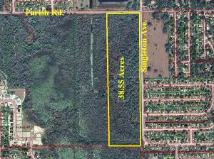
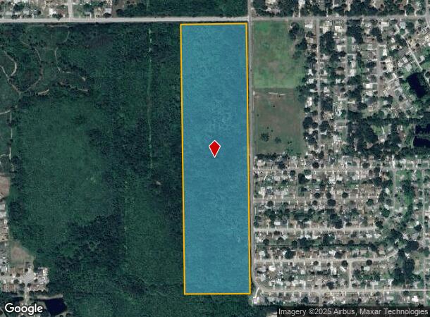
Property Record
1909 Unknown, , FL

NEARBY LISTINGS FOR SALE OR LEASE
Property Detail
1909 Unknown
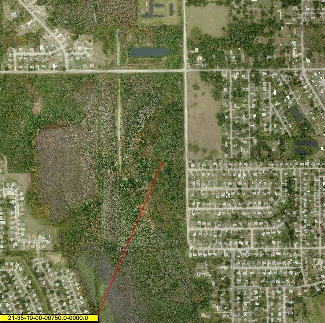
21-35-19-00-00750.0-0000.00
E 1/4 OF SE 1/4 EX RD R/W PARS 754,755,756
Residentialacreage
Brevard
A
Florida
12009C0115H
35.67 AC
2024
Brevard County
2025
Orlando
0603003010
Palm Bay-Melbourne-Titusville, FL
DEMOGRAPHICS near 1909 Unknown
1 Mile
3 Mile
5 Mile
2024 Total Population
4,985
22,666
42,045
2029 Population
5,438
24,834
46,170
Pop Growth 2024-2029
+ 9.09%
+ 9.56%
+ 9.81%
Average Age
45
45
44
2024 Total Households
2,095
9,271
17,564
HH Growth 2024-2029
+ 9.07%
+ 9.44%
+ 9.66%
Median Household Inc
$48,437
$54,702
$53,083
Avg Household Size
2.30
2.30
2.30
2024 Avg HH Vehicles
2.00
2.00
2.00
Median Home Value
$178,515
$212,037
$219,156
Median Year Built
1981
1981
1982
Nearby Places
- Restaurants
- Banks
- Shops
- Fitness
- Groceries
PUBLIC TRANSPORTATION
AIRPORT
Orlando Sanford International
DRIVE
WALK
Distance
Orlando Sanford International
72 min
48.5 mi
Freight Ports
Port Canaveral
DRIVE
WALK
Distance
Port Canaveral
44 min
31.4 mi
SALE & LEASE HISTORY
LISTING DATE
SALE/LEASE

Mar 29, 2017
For Sale
Nearby Properties
Address
Land Use
TOTAL SIZE
Lot Size
Zoning
Address
Land Use
TOTAL SIZE
Lot Size
Zoning
440,368 SF
60.44 AC
HM
Address
Land Use
TOTAL SIZE
Lot Size
Zoning
18,000 SF
16.54 AC
P
Address
Land Use
TOTAL SIZE
Lot Size
Zoning
172,172 SF
116.12 AC
P
Address
Land Use
TOTAL SIZE
Lot Size
Zoning
267,207 SF
36.82 AC
P
Address
Land Use
TOTAL SIZE
Lot Size
Zoning
3.25 AC
P
Address
Land Use
TOTAL SIZE
Lot Size
Zoning
130,615 SF
16.15 AC
RC
Address
Land Use
TOTAL SIZE
Lot Size
Zoning
87,904 SF
13.16 AC
RU19
Address
Land Use
TOTAL SIZE
Lot Size
Zoning
54,816 SF
10.11 AC
BU-1
Address
Land Use
TOTAL SIZE
Lot Size
Zoning
113,576 SF
19.98 AC
P
Address
Land Use
TOTAL SIZE
Lot Size
Zoning
64,036 SF
2.45 AC
R3
Address
Land Use
TOTAL SIZE
Lot Size
Zoning
46.75 AC
GML
Address
Land Use
TOTAL SIZE
Lot Size
Zoning
97,463 SF
19.50 AC
P
Address
Land Use
TOTAL SIZE
Lot Size
Zoning
68,385 SF
12 AC
P
Address
Land Use
TOTAL SIZE
Lot Size
Zoning
10,248 SF
41.06 AC
RU-1-7
Address
Land Use
TOTAL SIZE
Lot Size
Zoning
68,376 SF
2.57 AC
R3
Address
Land Use
TOTAL SIZE
Lot Size
Zoning
109,709 SF
5.83 AC
M1
Address
Land Use
TOTAL SIZE
Lot Size
Zoning
87,836 SF
8.89 AC
CC
Address
Land Use
TOTAL SIZE
Lot Size
Zoning
24,364 SF
14.08 AC
Address
Land Use
TOTAL SIZE
Lot Size
Zoning
67,723 SF
128.21 AC
P
Address
Land Use
TOTAL SIZE
Lot Size
Zoning
114.31 AC
GU
Address
Land Use
TOTAL SIZE
Lot Size
Zoning
63,506 SF
18.94 AC
GU
Address
Land Use
TOTAL SIZE
Lot Size
Zoning
47,643 SF
12.90 AC
OP
Address
Land Use
TOTAL SIZE
Lot Size
Zoning
47,186 SF
1.71 AC
R3
Address
Land Use
TOTAL SIZE
Lot Size
Zoning
79,025 SF
10.99 AC
Address
Land Use
TOTAL SIZE
Lot Size
Zoning
87.58 AC
GML
Address
Land Use
TOTAL SIZE
Lot Size
Zoning
24,586 SF
2.23 AC
CC
Address
Land Use
TOTAL SIZE
Lot Size
Zoning
55,304 SF
5 AC
OR
Address
Land Use
TOTAL SIZE
Lot Size
Zoning
48,519 SF
3.75 AC
RC
Address
Land Use
TOTAL SIZE
Lot Size
Zoning
9,961 SF
13.71 AC
RVP
Address
Land Use
TOTAL SIZE
Lot Size
Zoning
21,934 SF
8.05 AC
BU-1
The World's #1 Commercial Real Estate Marketplace
Connect with us
© 2025 CoStar Group
The information above has been obtained from sources believed reliable. While we do not doubt its accuracy we have not verified it and make no guarantee, warranty or representation about it. It is your responsibility to independently confirm its accuracy and completeness. Any projections, opinions, assumptions, or estimates used are for example only and do not represent the current or future performance of the property. The value of this transaction to you depends on tax and other factors which should be evaluated by your tax, financial, and legal advisors. You and your advisors should conduct a careful, independent investigation of the property to determine to your satisfaction the suitability of the property for your needs.