Property Record
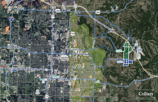
Parsons Rd, Springdale, AR 72764
Property Detail
Parsons Rd
001-18652-000
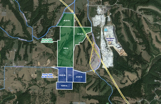
PT S/2 SW 40.33AC
Agriculturalnec
WASHINGTON
AA1
Arkansas
AE The base floodplain where base flood elevations are provided. AE Zones are now used on new format FIRMs instead of A1-A30 Zones.
128 AC
2025
Outlying Washington Cnty
2025
Fayetteville/Springdale/Rogers
010307
Fayetteville-Springdale-Rogers, AR
NEARBY LISTINGS FOR SALE OR LEASE
DEMOGRAPHICS near Parsons Rd
1 mile
3 mile
5 mile
2025 Total Population
260
9,523
53,911
2030 Population
280
10,285
58,206
Pop Growth 2025-2030
+ 7.69%
+ 8.00%
+ 7.97%
Average Age
39
35
34
2025 Total Households
90
3,026
16,711
HH Growth 2025-2030
+ 8.89%
+ 8.36%
+ 8.24%
Median Household Inc
$74,999
$68,252
$67,973
Avg Household Size
2.70
3.10
3.10
2025 Avg HH Vehicles
2.00
2.00
2.00
Median Home Value
$364,999
$283,937
$267,020
Median Year Built
1992
1996
1996
Nearby Places
Map Layers
Map Styles
 Street
 Aerial
Transit
 Traffic
 Biking
Places
Listings with unknown addresses are not visible on the map
- Restaurants
- Banks
- Shops
- Fitness
- Groceries
PUBLIC TRANSPORTATION
AIRPORT
Northwest Arkansas Ntl
Drive
Walk
Distance
Northwest Arkansas Ntl
44 min
21.9 mi
Freight Ports
Tulsa Port of Inola
Drive
Walk
Distance
Tulsa Port of Inola
114 min
92.9 mi
Nearby Properties
Address
Land Use
TOTAL SIZE
Lot Size
Zoning
Address
Land Use
TOTAL SIZE
Lot Size
Zoning
178,140 SF
4.39 AC
Address
Land Use
TOTAL SIZE
Lot Size
Zoning
74,434 SF
32.25 AC
Address
Land Use
TOTAL SIZE
Lot Size
Zoning
352,195 SF
15 AC
Address
Land Use
TOTAL SIZE
Lot Size
Zoning
153,968 SF
21 AC
Address
Land Use
TOTAL SIZE
Lot Size
Zoning
50,154 SF
4.09 AC
C2
Address
Land Use
TOTAL SIZE
Lot Size
Zoning
81,600 SF
6.98 AC
Address
Land Use
TOTAL SIZE
Lot Size
Zoning
16,800 SF
6.26 AC
Address
Land Use
TOTAL SIZE
Lot Size
Zoning
39,916 SF
5.24 AC
Address
Land Use
TOTAL SIZE
Lot Size
Zoning
79,272 SF
10.72 AC
Address
Land Use
TOTAL SIZE
Lot Size
Zoning
48,650 SF
2.74 AC
Address
Land Use
TOTAL SIZE
Lot Size
Zoning
39,064 SF
2.99 AC
Address
Land Use
TOTAL SIZE
Lot Size
Zoning
87,722 SF
2.41 AC
Address
Land Use
TOTAL SIZE
Lot Size
Zoning
55,362 SF
3.50 AC
Address
Land Use
TOTAL SIZE
Lot Size
Zoning
130,323 SF
7.73 AC
Address
Land Use
TOTAL SIZE
Lot Size
Zoning
15,700 SF
2.74 AC
Address
Land Use
TOTAL SIZE
Lot Size
Zoning
58,928 SF
4.77 AC
Address
Land Use
TOTAL SIZE
Lot Size
Zoning
54,980 SF
6.87 AC
Address
Land Use
TOTAL SIZE
Lot Size
Zoning
42,927 SF
14.27 AC
Address
Land Use
TOTAL SIZE
Lot Size
Zoning
27,824 SF
4.13 AC
C2
Address
Land Use
TOTAL SIZE
Lot Size
Zoning
37,500 SF
2.28 AC
Address
Land Use
TOTAL SIZE
Lot Size
Zoning
39,012 SF
2.30 AC
Address
Land Use
TOTAL SIZE
Lot Size
Zoning
32,400 SF
5.10 AC
Address
Land Use
TOTAL SIZE
Lot Size
Zoning
30,964 SF
2.53 AC
Address
Land Use
TOTAL SIZE
Lot Size
Zoning
57,449 SF
7.25 AC
Address
Land Use
TOTAL SIZE
Lot Size
Zoning
100,000 SF
5.83 AC
Address
Land Use
TOTAL SIZE
Lot Size
Zoning
1,642 SF
47.08 AC
AA1
Address
Land Use
TOTAL SIZE
Lot Size
Zoning
20,800 SF
3.81 AC
Address
Land Use
TOTAL SIZE
Lot Size
Zoning
63,200 SF
4.71 AC
Address
Land Use
TOTAL SIZE
Lot Size
Zoning
100,000 SF
2.78 AC
The World's #1 Commercial Real Estate Marketplace
Connect with us
© 2026 CoStar Group
The information above has been obtained from sources believed reliable. While we do not doubt its accuracy we have not verified it and make no guarantee, warranty or representation about it. It is your responsibility to independently confirm its accuracy and completeness. Any projections, opinions, assumptions, or estimates used are for example only and do not represent the current or future performance of the property. The value of this transaction to you depends on tax and other factors which should be evaluated by your tax, financial, and legal advisors. You and your advisors should conduct a careful, independent investigation of the property to determine to your satisfaction the suitability of the property for your needs.