Property Record
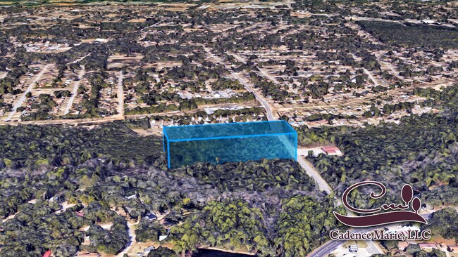
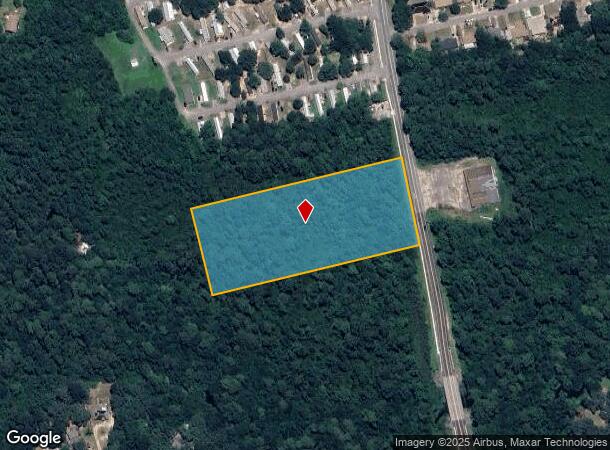
Patricia Dr, Pensacola, FL 32526


NEARBY LISTINGS FOR SALE OR LEASE
-
-
-
-
-
No Photo
-
-
-
View all Pensacola listings for sale on LoopNet.com
Property Detail
Patricia Dr
Pensacola-Ferry Pass-Brent, FL
Subdivision Number: 2000
37-2S-31-2000-000-003
BEG AT SE COR OF LOT 8 BLK F FIRST ADDN TO BAYOU MARCUS HTS PB 6 P 61 S 14 DEG E ALG EXTENSION OF E LINE OF SD S/D 249 04/100 FT N 76 DEG 01 MIN 40 SEC E 586 74/100 FT TO PT IN W R/W LINE PATRICIA DRIVE (66 FT R/W) S 09 DEG 14 MIN 20 SEC E ALG SD R/W
Residentialacreage
Escambia
AE
Florida
12033C0370G
8
2023
5 AC
2024
Myrtle Grove/Bellview
003308
Pensacola
DEMOGRAPHICS near Patricia Dr
1 Mile
3 Mile
5 Mile
2024 Total Population
8,215
54,005
113,920
2029 Population
8,293
54,748
116,529
Pop Growth 2024-2029
+ 0.95%
+ 1.38%
+ 2.29%
Average Age
39
38
39
2024 Total Households
3,281
20,822
44,781
HH Growth 2024-2029
+ 1.01%
+ 1.27%
+ 2.28%
Median Household Inc
$53,615
$48,440
$43,567
Avg Household Size
2.50
2.40
2.40
2024 Avg HH Vehicles
2.00
2.00
2.00
Median Home Value
$153,465
$138,194
$144,321
Median Year Built
1976
1977
1976
Nearby Places
Map Layers
Map Styles
 Street
 Aerial
- Restaurants
- Banks
- Shops
- Fitness
- Groceries
PUBLIC TRANSPORTATION
AIRPORT
Pensacola International
DRIVE
WALK
Distance
Pensacola International
18 min
8.6 mi
Freight Ports
Port of Mobile
DRIVE
WALK
Distance
Port of Mobile
67 min
55.0 mi
SALE & LEASE HISTORY
LISTING DATE
SALE/LEASE

Nov 04, 2022
For Sale
Jun 30, 2023
For Sale
Aug 26, 2022
For Sale
Nearby Properties
Address
Land Use
TOTAL SIZE
Lot Size
Zoning
Address
Land Use
TOTAL SIZE
Lot Size
Zoning
6,950 SF
584.36 AC
PUB
Address
Land Use
TOTAL SIZE
Lot Size
Zoning
288,114 SF
17.89 AC
HC/LI
Address
Land Use
TOTAL SIZE
Lot Size
Zoning
250,232 SF
19.24 AC
HDR
Address
Land Use
TOTAL SIZE
Lot Size
Zoning
207,331 SF
24.09 AC
HDR
Address
Land Use
TOTAL SIZE
Lot Size
Zoning
219,481 SF
161.44 AC
NONE
Address
Land Use
TOTAL SIZE
Lot Size
Zoning
334,324 SF
55.06 AC
PUB
Address
Land Use
TOTAL SIZE
Lot Size
Zoning
127,684 SF
8.24 AC
HDR
Address
Land Use
TOTAL SIZE
Lot Size
Zoning
169,346 SF
15.21 AC
HDR
Address
Land Use
TOTAL SIZE
Lot Size
Zoning
158,233 SF
9.15 AC
HDMU
Address
Land Use
TOTAL SIZE
Lot Size
Zoning
133,096 SF
10.32 AC
HDR
Address
Land Use
TOTAL SIZE
Lot Size
Zoning
99,147 SF
5.89 AC
HDMU
Address
Land Use
TOTAL SIZE
Lot Size
Zoning
116,020 SF
4.71 AC
MDR
Address
Land Use
TOTAL SIZE
Lot Size
Zoning
197,958 SF
26.08 AC
COM
Address
Land Use
TOTAL SIZE
Lot Size
Zoning
184,232 SF
11.32 AC
HC/LI
Address
Land Use
TOTAL SIZE
Lot Size
Zoning
129,532 SF
10.84 AC
COM
Address
Land Use
TOTAL SIZE
Lot Size
Zoning
103,671 SF
13.96 AC
HDMU
Address
Land Use
TOTAL SIZE
Lot Size
Zoning
138,048 SF
22.64 AC
HC/LI
Address
Land Use
TOTAL SIZE
Lot Size
Zoning
223,987 SF
36.60 AC
MDR
Address
Land Use
TOTAL SIZE
Lot Size
Zoning
371,425 SF
24.78 AC
HC/LI
Address
Land Use
TOTAL SIZE
Lot Size
Zoning
81,874 SF
7.09 AC
HDMU
Address
Land Use
TOTAL SIZE
Lot Size
Zoning
61,788 SF
8.60 AC
HDR
Address
Land Use
TOTAL SIZE
Lot Size
Zoning
64,870 SF
5.35 AC
HDMU
Address
Land Use
TOTAL SIZE
Lot Size
Zoning
3,926 SF
57.46 AC
HDMU
Address
Land Use
TOTAL SIZE
Lot Size
Zoning
84,005 SF
7.93 AC
COM
Address
Land Use
TOTAL SIZE
Lot Size
Zoning
65,355 SF
6.27 AC
COM
Address
Land Use
TOTAL SIZE
Lot Size
Zoning
78,174 SF
4.52 AC
HDMU
Address
Land Use
TOTAL SIZE
Lot Size
Zoning
105,225 SF
2.72 AC
HC/LI
Address
Land Use
TOTAL SIZE
Lot Size
Zoning
90,932 SF
7.37 AC
HDMU,MDR
Address
Land Use
TOTAL SIZE
Lot Size
Zoning
103,098 SF
4.20 AC
HC/LI
Address
Land Use
TOTAL SIZE
Lot Size
Zoning
98,372 SF
16.95 AC
COM
The World's #1 Commercial Real Estate Marketplace
Connect with us
© 2025 CoStar Group
The information above has been obtained from sources believed reliable. While we do not doubt its accuracy we have not verified it and make no guarantee, warranty or representation about it. It is your responsibility to independently confirm its accuracy and completeness. Any projections, opinions, assumptions, or estimates used are for example only and do not represent the current or future performance of the property. The value of this transaction to you depends on tax and other factors which should be evaluated by your tax, financial, and legal advisors. You and your advisors should conduct a careful, independent investigation of the property to determine to your satisfaction the suitability of the property for your needs.