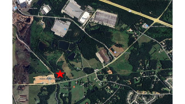
Property Record
Patrick Mill Rd Sw, Winder, GA 30680

Property Detail
Patrick Mill Rd Sw
Atlanta-Sandy Springs-Roswell, GA
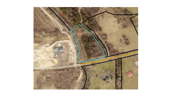
TRACT 5
XX043-012R
BARROW
Residentialacreage
Georgia
R-3
5.81 AC
2025
Barrow County
2025
Atlanta
180203
NEARBY LISTINGS FOR SALE OR LEASE
DEMOGRAPHICS near Patrick Mill Rd Sw
1 mile
3 mile
5 mile
2025 Total Population
2,012
18,846
56,071
2030 Population
2,228
20,924
62,085
Pop Growth 2025-2030
+ 10.74%
+ 11.03%
+ 10.73%
Average Age
36
36
37
2025 Total Households
637
6,002
18,098
HH Growth 2025-2030
+ 10.52%
+ 11.15%
+ 10.97%
Median Household Inc
$94,774
$93,586
$84,863
Avg Household Size
3.10
3.10
3.10
2025 Avg HH Vehicles
2.00
2.00
2.00
Median Home Value
$299,045
$336,512
$344,401
Median Year Built
2005
2004
2001
Nearby Places
Map Layers
Map Styles
 Street
 Aerial
Transit
 Traffic
 Biking
Places
Listings with unknown addresses are not visible on the map
- Restaurants
- Banks
- Shops
- Fitness
- Groceries
SALE & LEASE HISTORY
LISTING DATE
SALE/LEASE

Apr 01, 2025
For Sale
Nearby Properties
Address
Land Use
TOTAL SIZE
Lot Size
Zoning
Address
Land Use
TOTAL SIZE
Lot Size
Zoning
10,128 SF
28.19 AC
R-3
Address
Land Use
TOTAL SIZE
Lot Size
Zoning
103.23 AC
R100MOD
Address
Land Use
TOTAL SIZE
Lot Size
Zoning
420,876 SF
26.84 AC
M-2
Address
Land Use
TOTAL SIZE
Lot Size
Zoning
164,877 SF
34.89 AC
C1
Address
Land Use
TOTAL SIZE
Lot Size
Zoning
22,320 SF
15.90 AC
R-3
Address
Land Use
TOTAL SIZE
Lot Size
Zoning
120,000 SF
142.73 AC
AG
Address
Land Use
TOTAL SIZE
Lot Size
Zoning
305,327 SF
22.05 AC
M-2
Address
Land Use
TOTAL SIZE
Lot Size
Zoning
301,200 SF
39.18 AC
M-2
Address
Land Use
TOTAL SIZE
Lot Size
Zoning
231,285 SF
34.50 AC
M-2
Address
Land Use
TOTAL SIZE
Lot Size
Zoning
167,580 SF
21.82 AC
M-2
Address
Land Use
TOTAL SIZE
Lot Size
Zoning
183,060 SF
17.90 AC
M-2
Address
Land Use
TOTAL SIZE
Lot Size
Zoning
104,805 SF
12.54 AC
C-3
Address
Land Use
TOTAL SIZE
Lot Size
Zoning
89,520 SF
13.99 AC
M-2
Address
Land Use
TOTAL SIZE
Lot Size
Zoning
23,546 SF
24.55 AC
RA200
Address
Land Use
TOTAL SIZE
Lot Size
Zoning
2,398 SF
8.13 AC
R-3
Address
Land Use
TOTAL SIZE
Lot Size
Zoning
1,188 SF
7.63 AC
R-3
Address
Land Use
TOTAL SIZE
Lot Size
Zoning
64,800 SF
47.27 AC
M-1
Address
Land Use
TOTAL SIZE
Lot Size
Zoning
20,660 SF
10.94 AC
RA200
Address
Land Use
TOTAL SIZE
Lot Size
Zoning
38,550 SF
3.04 AC
C-2
Address
Land Use
TOTAL SIZE
Lot Size
Zoning
55,420 SF
5.05 AC
C-3
Address
Land Use
TOTAL SIZE
Lot Size
Zoning
15,808 SF
16.43 AC
RA200
Address
Land Use
TOTAL SIZE
Lot Size
Zoning
105.99 AC
C-3
Address
Land Use
TOTAL SIZE
Lot Size
Zoning
16,384 SF
5.10 AC
RA200
Address
Land Use
TOTAL SIZE
Lot Size
Zoning
212.21 AC
RA200
Address
Land Use
TOTAL SIZE
Lot Size
Zoning
153 AC
R100
Address
Land Use
TOTAL SIZE
Lot Size
Zoning
1,036 SF
120.72 AC
C1
Address
Land Use
TOTAL SIZE
Lot Size
Zoning
14,300 SF
5.77 AC
M-1
Address
Land Use
TOTAL SIZE
Lot Size
Zoning
95.60 AC
RA200
Address
Land Use
TOTAL SIZE
Lot Size
Zoning
5,198 SF
8 AC
RA200
Address
Land Use
TOTAL SIZE
Lot Size
Zoning
49,527 SF
19.22 AC
M-2
The World's #1 Commercial Real Estate Marketplace
Connect with us
© 2026 CoStar Group
The information above has been obtained from sources believed reliable. While we do not doubt its accuracy we have not verified it and make no guarantee, warranty or representation about it. It is your responsibility to independently confirm its accuracy and completeness. Any projections, opinions, assumptions, or estimates used are for example only and do not represent the current or future performance of the property. The value of this transaction to you depends on tax and other factors which should be evaluated by your tax, financial, and legal advisors. You and your advisors should conduct a careful, independent investigation of the property to determine to your satisfaction the suitability of the property for your needs.