Property Record
Patrick Rd, Waxahachie, TX 75167
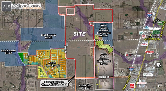

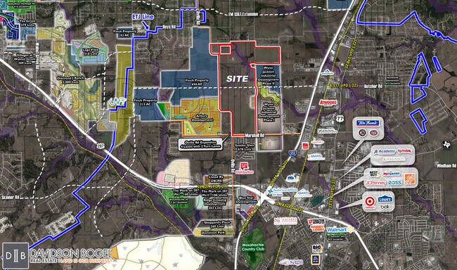
Property Detail
Patrick Rd
Dallas-Fort Worth-Arlington, TX
297 WM DOWNING 194.61 ACRES
182296
ELLIS
Farms
Texas
B and X Area of moderate flood hazard, usually the area between the limits of the 100-year and 500-year floods.
194.61 AC
2024
Ellis County
2025
Dallas/Ft Worth
061100
NEARBY LISTINGS FOR SALE OR LEASE
DEMOGRAPHICS near Patrick Rd
1 mile
3 mile
5 mile
2025 Total Population
67
15,144
68,238
2030 Population
78
17,725
79,843
Pop Growth 2025-2030
+ 16.42%
+ 17.04%
+ 17.01%
Average Age
39
38
38
2025 Total Households
23
5,340
23,498
HH Growth 2025-2030
+ 13.04%
+ 17.04%
+ 17.05%
Median Household Inc
$106,250
$98,475
$98,791
Avg Household Size
2.90
2.80
2.80
2025 Avg HH Vehicles
3.00
2.00
2.00
Median Home Value
$381,249
$408,333
$398,250
Median Year Built
2006
2006
2004
Nearby Places
Map Layers
Map Styles
 Street
 Aerial
Layers
 Traffic
 Biking
Places
Listings with unknown addresses are not visible on the map
- Restaurants
- Banks
- Shops
- Fitness
- Groceries
PUBLIC TRANSPORTATION
AIRPORT
Dallas Love Field
Drive
Walk
Distance
Dallas Love Field
49 min
34.6 mi
Freight Ports
Port of Shreveport
Drive
Walk
Distance
Port of Shreveport
236 min
215.7 mi
Nearby Properties
Address
Land Use
TOTAL SIZE
Lot Size
Zoning
Address
Land Use
TOTAL SIZE
Lot Size
Zoning
488,705 SF
43.76 AC
Address
Land Use
TOTAL SIZE
Lot Size
Zoning
413,618 SF
94.72 AC
Address
Land Use
TOTAL SIZE
Lot Size
Zoning
146,074 SF
42.83 AC
Address
Land Use
TOTAL SIZE
Lot Size
Zoning
643,064 SF
42.15 AC
Address
Land Use
TOTAL SIZE
Lot Size
Zoning
259,166 SF
11.07 AC
Address
Land Use
TOTAL SIZE
Lot Size
Zoning
675,375 SF
59.26 AC
Address
Land Use
TOTAL SIZE
Lot Size
Zoning
193,837 SF
10.41 AC
Address
Land Use
TOTAL SIZE
Lot Size
Zoning
177,000 SF
20.25 AC
Address
Land Use
TOTAL SIZE
Lot Size
Zoning
708,800 SF
149.18 AC
Address
Land Use
TOTAL SIZE
Lot Size
Zoning
198,180 SF
11.48 AC
Address
Land Use
TOTAL SIZE
Lot Size
Zoning
1,123,347 SF
74.97 AC
Address
Land Use
TOTAL SIZE
Lot Size
Zoning
413,050 SF
54.30 AC
Address
Land Use
TOTAL SIZE
Lot Size
Zoning
178,880 SF
5.51 AC
Address
Land Use
TOTAL SIZE
Lot Size
Zoning
85,823 SF
56.24 AC
Address
Land Use
TOTAL SIZE
Lot Size
Zoning
118,782 SF
5.11 AC
Address
Land Use
TOTAL SIZE
Lot Size
Zoning
326,740 SF
23.01 AC
Address
Land Use
TOTAL SIZE
Lot Size
Zoning
352,350 SF
18.78 AC
Address
Land Use
TOTAL SIZE
Lot Size
Zoning
568,234 SF
65.79 AC
Address
Land Use
TOTAL SIZE
Lot Size
Zoning
886,858 SF
8.60 AC
Address
Land Use
TOTAL SIZE
Lot Size
Zoning
92,475 SF
12.38 AC
Address
Land Use
TOTAL SIZE
Lot Size
Zoning
326,130 SF
18.48 AC
Address
Land Use
TOTAL SIZE
Lot Size
Zoning
115,544 SF
6.70 AC
Address
Land Use
TOTAL SIZE
Lot Size
Zoning
120,587 SF
23.95 AC
Address
Land Use
TOTAL SIZE
Lot Size
Zoning
92,860 SF
26.02 AC
Address
Land Use
TOTAL SIZE
Lot Size
Zoning
Address
Land Use
TOTAL SIZE
Lot Size
Zoning
109,423 SF
7.04 AC
Address
Land Use
TOTAL SIZE
Lot Size
Zoning
60,041 SF
6.76 AC
Address
Land Use
TOTAL SIZE
Lot Size
Zoning
871,497 SF
134.08 AC
Address
Land Use
TOTAL SIZE
Lot Size
Zoning
86,360 SF
4.26 AC
Address
Land Use
TOTAL SIZE
Lot Size
Zoning
57,600 SF
5.86 AC
The World's #1 Commercial Real Estate Marketplace
Connect with us
© 2026 CoStar Group
The information above has been obtained from sources believed reliable. While we do not doubt its accuracy we have not verified it and make no guarantee, warranty or representation about it. It is your responsibility to independently confirm its accuracy and completeness. Any projections, opinions, assumptions, or estimates used are for example only and do not represent the current or future performance of the property. The value of this transaction to you depends on tax and other factors which should be evaluated by your tax, financial, and legal advisors. You and your advisors should conduct a careful, independent investigation of the property to determine to your satisfaction the suitability of the property for your needs.