Property Record
Paxton Rd, Yucca Valley, CA 92284


Save to a Folder
{{folder.Name}}
{{folder.ListingIds.length}} Properties
{{folder.ListingIds.length}} Property
Create a New Folder
Property Detail
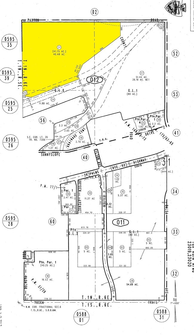
Paxton Rd
Riverside-San Bernardino-Ontario, CA
PTN NW 1/4 SEC 31 TP 1N R 6E COM AT A PT IN W LI SD NW 1/4 SD SEC THAT BEARS N 0 DEG 12 MIN 31 SECONDS E A DISTANCE OF 1128.72 FT FROM SW COR SD NW 1/4 TH N 69 DEG 36 MIN 51 SECONDS E 1134.24 FT TH N 20 DEG 23 MIN 09 SECONDS W 90FT TH N 27 DEG 02 MIN
0601-012-31
SAN BERNARDINO
Vacantlandnec
California
AE The base floodplain where base flood elevations are provided. AE Zones are now used on new format FIRMs instead of A1-A30 Zones.
40.48 AC
2025
Twentynine Palms
2026
Inland Empire (California)
010428
NEARBY LISTINGS FOR SALE OR LEASE
DEMOGRAPHICS near Paxton Rd
1 mile
3 mile
5 mile
2025 Total Population
2,534
19,994
30,879
2030 Population
2,603
20,572
31,907
Pop Growth 2025-2030
+ 2.72%
+ 2.89%
+ 3.33%
Average Age
41
42
43
2025 Total Households
1,002
8,016
12,658
HH Growth 2025-2030
+ 2.69%
+ 2.91%
+ 3.37%
Median Household Inc
$61,660
$61,526
$63,155
Avg Household Size
2.50
2.50
2.40
2025 Avg HH Vehicles
2.00
2.00
2.00
Median Home Value
$406,800
$357,637
$379,715
Median Year Built
1985
1981
1981
Nearby Places
Map Layers
Map Styles
 Street
 Aerial
Layers
 Traffic
 Biking
Places
Listings with unknown addresses are not visible on the map
- Restaurants
- Banks
- Shops
- Fitness
- Groceries
PUBLIC TRANSPORTATION
AIRPORT
Palm Springs International
Drive
Walk
Distance
Palm Springs International
46 min
32.9 mi
Freight Ports
Port of Long Beach
Drive
Walk
Distance
Port of Long Beach
158 min
124.8 mi
Nearby Properties
Address
Land Use
TOTAL SIZE
Lot Size
Zoning
Address
Land Use
TOTAL SIZE
Lot Size
Zoning
196,781 SF
23.85 AC
Address
Land Use
TOTAL SIZE
Lot Size
Zoning
102,500 SF
13.07 AC
Address
Land Use
TOTAL SIZE
Lot Size
Zoning
178,083 SF
1.75 AC
Address
Land Use
TOTAL SIZE
Lot Size
Zoning
30,393 SF
3.83 AC
Address
Land Use
TOTAL SIZE
Lot Size
Zoning
51,455 SF
2.83 AC
Address
Land Use
TOTAL SIZE
Lot Size
Zoning
31,345 SF
10.12 AC
Address
Land Use
TOTAL SIZE
Lot Size
Zoning
81,904 SF
2 AC
Address
Land Use
TOTAL SIZE
Lot Size
Zoning
104,442 SF
7.29 AC
Address
Land Use
TOTAL SIZE
Lot Size
Zoning
17,299 SF
1.74 AC
Address
Land Use
TOTAL SIZE
Lot Size
Zoning
41,321 SF
1.83 AC
Address
Land Use
TOTAL SIZE
Lot Size
Zoning
89,981 SF
8.08 AC
Address
Land Use
TOTAL SIZE
Lot Size
Zoning
25,193 SF
2.72 AC
Address
Land Use
TOTAL SIZE
Lot Size
Zoning
19,950 SF
1.57 AC
Address
Land Use
TOTAL SIZE
Lot Size
Zoning
20,485 SF
2.39 AC
Address
Land Use
TOTAL SIZE
Lot Size
Zoning
50,784 SF
11.37 AC
Address
Land Use
TOTAL SIZE
Lot Size
Zoning
10,399 SF
22.87 AC
Address
Land Use
TOTAL SIZE
Lot Size
Zoning
18,152 SF
5 AC
Address
Land Use
TOTAL SIZE
Lot Size
Zoning
14,285 SF
1.52 AC
Address
Land Use
TOTAL SIZE
Lot Size
Zoning
40,000 SF
3.03 AC
Address
Land Use
TOTAL SIZE
Lot Size
Zoning
46,334 SF
2.20 AC
Address
Land Use
TOTAL SIZE
Lot Size
Zoning
52,500 SF
2.97 AC
926
Address
Land Use
TOTAL SIZE
Lot Size
Zoning
24,693 SF
2.31 AC
Address
Land Use
TOTAL SIZE
Lot Size
Zoning
7,668 SF
0.99 AC
Address
Land Use
TOTAL SIZE
Lot Size
Zoning
17,422 SF
2.40 AC
Address
Land Use
TOTAL SIZE
Lot Size
Zoning
32,900 SF
4.18 AC
Address
Land Use
TOTAL SIZE
Lot Size
Zoning
131.42 AC
Address
Land Use
TOTAL SIZE
Lot Size
Zoning
18,124 SF
1.07 AC
Address
Land Use
TOTAL SIZE
Lot Size
Zoning
10,064 SF
0.88 AC
Address
Land Use
TOTAL SIZE
Lot Size
Zoning
49,282 SF
2.74 AC
Address
Land Use
TOTAL SIZE
Lot Size
Zoning
22,981 SF
2.02 AC
The World's #1 Commercial Real Estate Marketplace
Connect with us
© 2026 CoStar Group
The information above has been obtained from sources believed reliable. While we do not doubt its accuracy we have not verified it and make no guarantee, warranty or representation about it. It is your responsibility to independently confirm its accuracy and completeness. Any projections, opinions, assumptions, or estimates used are for example only and do not represent the current or future performance of the property. The value of this transaction to you depends on tax and other factors which should be evaluated by your tax, financial, and legal advisors. You and your advisors should conduct a careful, independent investigation of the property to determine to your satisfaction the suitability of the property for your needs.