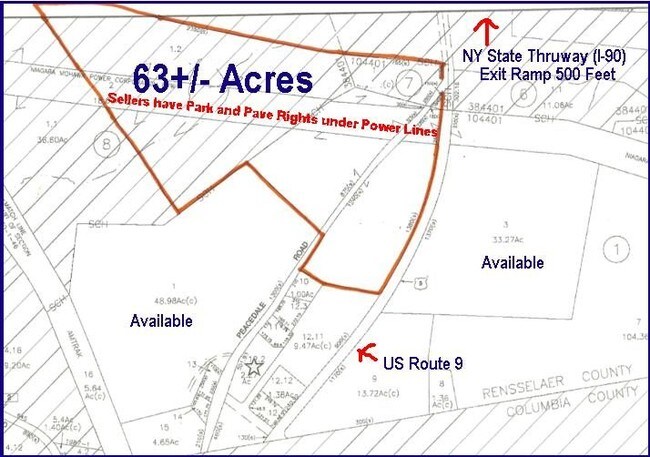
Property Record
Peacedale Rd, Schodack Landing, NY 12156

NEARBY LISTINGS FOR SALE OR LEASE
-
-
View all Schodack Landing listings for sale on LoopNet.com
Property Detail
Peacedale Rd
Albany-Schenectady-Troy, NY
APT & STAND
4489-220-7-1
Rensselaer
Commercialacreage
New York
ARE
2.000
36083C0485D
4.60 AC
2025
Outer Rensselaer County
2024
Albany/Schenectady/Troy
052501
DEMOGRAPHICS near Peacedale Rd
1 Mile
3 Mile
5 Mile
2024 Total Population
276
4,829
14,499
2029 Population
272
4,736
14,228
Pop Growth 2024-2029
(1.45%)
(1.93%)
(1.87%)
Average Age
43
44
44
2024 Total Households
110
2,006
5,859
HH Growth 2024-2029
(0.91%)
(2.04%)
(2.01%)
Median Household Inc
$84,375
$87,060
$89,992
Avg Household Size
2.40
2.40
2.40
2024 Avg HH Vehicles
2.00
2.00
2.00
Median Home Value
$264,583
$267,882
$255,391
Median Year Built
1971
1973
1968
Nearby Places
- Restaurants
- Banks
- Shops
- Fitness
- Groceries
PUBLIC TRANSPORTATION
AIRPORT
Albany International
DRIVE
WALK
Distance
Albany International
35 min
24.2 mi
Freight Ports
Albany, NY Port
DRIVE
WALK
Distance
Albany, NY Port
25 min
18.2 mi
SALE & LEASE HISTORY
LISTING DATE
SALE/LEASE

Sep 24, 2016
For Sale
Nearby Properties
Address
Land Use
TOTAL SIZE
Lot Size
Zoning
Address
Land Use
TOTAL SIZE
Lot Size
Zoning
97,278 SF
47.70 AC
07 - MIXED
Address
Land Use
TOTAL SIZE
Lot Size
Zoning
488,000 SF
101.90 AC
HC
Address
Land Use
TOTAL SIZE
Lot Size
Zoning
59,049 SF
233 AC
07 - MIXED
Address
Land Use
TOTAL SIZE
Lot Size
Zoning
23,200 SF
16.71 AC
HC
Address
Land Use
TOTAL SIZE
Lot Size
Zoning
7,384 SF
4.13 AC
HC
Address
Land Use
TOTAL SIZE
Lot Size
Zoning
78,000 SF
8.76 AC
HC
Address
Land Use
TOTAL SIZE
Lot Size
Zoning
648 SF
46.65 AC
RA
Address
Land Use
TOTAL SIZE
Lot Size
Zoning
6,362 SF
166.30 AC
05 - COMME
Address
Land Use
TOTAL SIZE
Lot Size
Zoning
6,440 SF
7.54 AC
PD-1
Address
Land Use
TOTAL SIZE
Lot Size
Zoning
11,838 SF
4.55 AC
07 - MIXED
Address
Land Use
TOTAL SIZE
Lot Size
Zoning
82,771 SF
10.50 AC
07 - MIXED
Address
Land Use
TOTAL SIZE
Lot Size
Zoning
84.40 AC
Address
Land Use
TOTAL SIZE
Lot Size
Zoning
18,831 SF
25 AC
PD-4
Address
Land Use
TOTAL SIZE
Lot Size
Zoning
1,810 SF
185.02 AC
04 - FARM
Address
Land Use
TOTAL SIZE
Lot Size
Zoning
31,920 SF
7.68 AC
HC
Address
Land Use
TOTAL SIZE
Lot Size
Zoning
3,872 SF
17.81 AC
HC
Address
Land Use
TOTAL SIZE
Lot Size
Zoning
14,400 SF
20 AC
05 - COMME
Address
Land Use
TOTAL SIZE
Lot Size
Zoning
25,810 SF
4.75 AC
HC
Address
Land Use
TOTAL SIZE
Lot Size
Zoning
13,440 SF
2.40 AC
05 - COMME
Address
Land Use
TOTAL SIZE
Lot Size
Zoning
1,200 SF
15.40 AC
07 - MIXED
Address
Land Use
TOTAL SIZE
Lot Size
Zoning
7,448 SF
1.36 AC
05 - COMME
Address
Land Use
TOTAL SIZE
Lot Size
Zoning
1,950 SF
26 AC
02 - SINGL
Address
Land Use
TOTAL SIZE
Lot Size
Zoning
16,800 SF
8.57 AC
HC
Address
Land Use
TOTAL SIZE
Lot Size
Zoning
12,300 SF
5.90 AC
05 - COMME
Address
Land Use
TOTAL SIZE
Lot Size
Zoning
1,856 SF
104.22 AC
RA
Address
Land Use
TOTAL SIZE
Lot Size
Zoning
5,152 SF
26.16 AC
PD-1
Address
Land Use
TOTAL SIZE
Lot Size
Zoning
2,760 SF
66.80 AC
HC
Address
Land Use
TOTAL SIZE
Lot Size
Zoning
11,234 SF
82.85 AC
HC
Address
Land Use
TOTAL SIZE
Lot Size
Zoning
15,800 SF
2.54 AC
HC
Address
Land Use
TOTAL SIZE
Lot Size
Zoning
6,322 SF
11.10 AC
02 - SINGL
The World's #1 Commercial Real Estate Marketplace
Connect with us
© 2025 CoStar Group
The information above has been obtained from sources believed reliable. While we do not doubt its accuracy we have not verified it and make no guarantee, warranty or representation about it. It is your responsibility to independently confirm its accuracy and completeness. Any projections, opinions, assumptions, or estimates used are for example only and do not represent the current or future performance of the property. The value of this transaction to you depends on tax and other factors which should be evaluated by your tax, financial, and legal advisors. You and your advisors should conduct a careful, independent investigation of the property to determine to your satisfaction the suitability of the property for your needs.