Property Record
Peachoid Rd, Gaffney, SC 29341

Property Detail
Peachoid Rd
Gaffney, SC
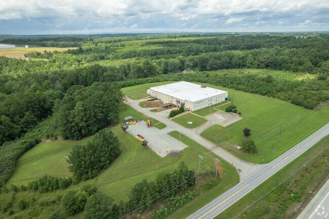
PEACHOID RD 43.40AC PP 46940/ 611 00186 SCTC FILE # SOLD 6 AC TO 062-021.001/ BAL 43.004
062-00-00-021.000
CHEROKEE
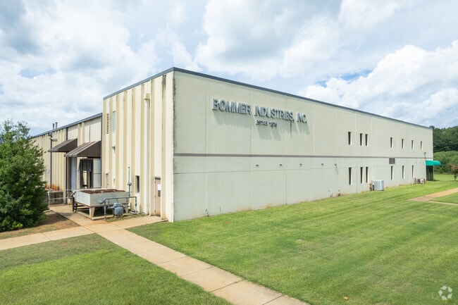
Storemultistory
South Carolina
A Areas with a 1% annual chance of flooding and a 26% chance of flooding over the life of a 30-year mortgage.
43.40 AC
2025
Cherokee County
2025
Greenville/Spartanburg
970204
NEARBY LISTINGS FOR SALE OR LEASE
DEMOGRAPHICS near Peachoid Rd
1 mile
3 mile
5 mile
2025 Total Population
996
11,238
28,337
2030 Population
1,011
11,587
29,342
Pop Growth 2025-2030
+ 1.51%
+ 3.11%
+ 3.55%
Average Age
42
41
40
2025 Total Households
440
4,782
11,315
HH Growth 2025-2030
+ 1.59%
+ 3.16%
+ 3.60%
Median Household Inc
$50,869
$47,665
$45,368
Avg Household Size
2.30
2.30
2.40
2025 Avg HH Vehicles
2.00
2.00
2.00
Median Home Value
$190,658
$194,697
$166,612
Median Year Built
1980
1979
1978
Nearby Places
Map Layers
Map Styles
 Street
 Aerial
Layers
 Traffic
 Biking
Places
Listings with unknown addresses are not visible on the map
- Restaurants
- Banks
- Shops
- Fitness
- Groceries
Nearby Properties
Address
Land Use
TOTAL SIZE
Lot Size
Zoning
Address
Land Use
TOTAL SIZE
Lot Size
Zoning
60,000 SF
11 AC
Address
Land Use
TOTAL SIZE
Lot Size
Zoning
4.92 AC
GF
Address
Land Use
TOTAL SIZE
Lot Size
Zoning
4.62 AC
GF
Address
Land Use
TOTAL SIZE
Lot Size
Zoning
11.56 AC
GF
Address
Land Use
TOTAL SIZE
Lot Size
Zoning
144.18 AC
Address
Land Use
TOTAL SIZE
Lot Size
Zoning
101.59 AC
Address
Land Use
TOTAL SIZE
Lot Size
Zoning
45.84 AC
GF
Address
Land Use
TOTAL SIZE
Lot Size
Zoning
20.39 AC
GF
Address
Land Use
TOTAL SIZE
Lot Size
Zoning
6,148 SF
1.67 AC
Address
Land Use
TOTAL SIZE
Lot Size
Zoning
7,260 SF
1.06 AC
GF
Address
Land Use
TOTAL SIZE
Lot Size
Zoning
3.50 AC
GF
Address
Land Use
TOTAL SIZE
Lot Size
Zoning
184.23 AC
Address
Land Use
TOTAL SIZE
Lot Size
Zoning
61.68 AC
Address
Land Use
TOTAL SIZE
Lot Size
Zoning
34.86 AC
GF
Address
Land Use
TOTAL SIZE
Lot Size
Zoning
24,610 SF
1.56 AC
GF
Address
Land Use
TOTAL SIZE
Lot Size
Zoning
0.11 AC
Address
Land Use
TOTAL SIZE
Lot Size
Zoning
9 AC
GF
Address
Land Use
TOTAL SIZE
Lot Size
Zoning
69.49 AC
Address
Land Use
TOTAL SIZE
Lot Size
Zoning
40 AC
GF
Address
Land Use
TOTAL SIZE
Lot Size
Zoning
23,774 SF
6 AC
GF
Address
Land Use
TOTAL SIZE
Lot Size
Zoning
114.24 AC
Address
Land Use
TOTAL SIZE
Lot Size
Zoning
8.74 AC
Address
Land Use
TOTAL SIZE
Lot Size
Zoning
7.53 AC
GF
Address
Land Use
TOTAL SIZE
Lot Size
Zoning
5.30 AC
GF
Address
Land Use
TOTAL SIZE
Lot Size
Zoning
7.04 AC
GF
Address
Land Use
TOTAL SIZE
Lot Size
Zoning
123.79 AC
Address
Land Use
TOTAL SIZE
Lot Size
Zoning
7.16 AC
Address
Land Use
TOTAL SIZE
Lot Size
Zoning
17.49 AC
GF
Address
Land Use
TOTAL SIZE
Lot Size
Zoning
5,750 SF
0.19 AC
GF
Address
Land Use
TOTAL SIZE
Lot Size
Zoning
1.07 AC
GF
The World's #1 Commercial Real Estate Marketplace
Connect with us
© 2026 CoStar Group
The information above has been obtained from sources believed reliable. While we do not doubt its accuracy we have not verified it and make no guarantee, warranty or representation about it. It is your responsibility to independently confirm its accuracy and completeness. Any projections, opinions, assumptions, or estimates used are for example only and do not represent the current or future performance of the property. The value of this transaction to you depends on tax and other factors which should be evaluated by your tax, financial, and legal advisors. You and your advisors should conduct a careful, independent investigation of the property to determine to your satisfaction the suitability of the property for your needs.