Property Record
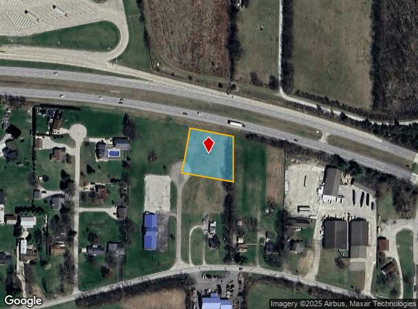
Pear Tree Rd, West Harrison, IN 47060
NEARBY LISTINGS FOR SALE OR LEASE
Property Detail
Pear Tree Rd
Cincinnati, OH-KY-IN
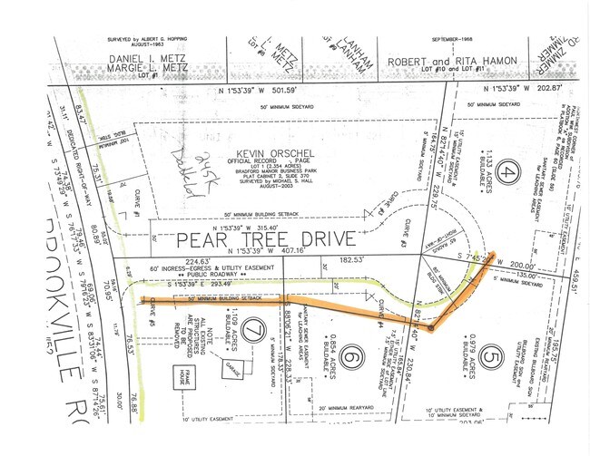
Bradford Manor Business Park
15-01-12-400-075.000-006
66-05 BRADFORD MANOR BUSINESS PARK 5 12-7-1 .979A REPLAT 10-27-06 FROM LOT 2
Commercialacreage
Dearborn
X
Indiana
18029C0064C
2
2024
0.98 AC
2024
Dearborn County
080204
Cincinnati/Dayton
DEMOGRAPHICS near Pear Tree Rd
1 Mile
3 Mile
5 Mile
2024 Total Population
393
12,661
28,529
2029 Population
398
12,546
28,548
Pop Growth 2024-2029
+ 1.27%
(0.91%)
+ 0.07%
Average Age
42
41
41
2024 Total Households
169
5,108
10,943
HH Growth 2024-2029
+ 1.18%
(0.98%)
(0.07%)
Median Household Inc
$39,374
$76,253
$87,316
Avg Household Size
2.30
2.50
2.60
2024 Avg HH Vehicles
2.00
2.00
2.00
Median Home Value
$212,500
$193,088
$230,686
Median Year Built
1981
1983
1988
Nearby Places
Map Layers
Map Styles
 Street
 Aerial
- Restaurants
- Banks
- Shops
- Fitness
- Groceries
PUBLIC TRANSPORTATION
AIRPORT
Cincinnati/Northern Kentucky International
DRIVE
WALK
Distance
Cincinnati/Northern Kentucky International
48 min
31.8 mi
SALE & LEASE HISTORY
LISTING DATE
SALE/LEASE

Oct 25, 2016
For Sale
Nearby Properties
Address
Land Use
TOTAL SIZE
Lot Size
Zoning
Address
Land Use
TOTAL SIZE
Lot Size
Zoning
85,849 SF
14.25 AC
Address
Land Use
TOTAL SIZE
Lot Size
Zoning
22.19 AC
Address
Land Use
TOTAL SIZE
Lot Size
Zoning
8.43 AC
Address
Land Use
TOTAL SIZE
Lot Size
Zoning
Address
Land Use
TOTAL SIZE
Lot Size
Zoning
27,234 SF
12.68 AC
Address
Land Use
TOTAL SIZE
Lot Size
Zoning
19.13 AC
Address
Land Use
TOTAL SIZE
Lot Size
Zoning
61.50 AC
H
Address
Land Use
TOTAL SIZE
Lot Size
Zoning
11.90 AC
Address
Land Use
TOTAL SIZE
Lot Size
Zoning
7.86 AC
Address
Land Use
TOTAL SIZE
Lot Size
Zoning
12.34 AC
Address
Land Use
TOTAL SIZE
Lot Size
Zoning
5,320 SF
26.52 AC
Address
Land Use
TOTAL SIZE
Lot Size
Zoning
27,586 SF
8 AC
Address
Land Use
TOTAL SIZE
Lot Size
Zoning
19.28 AC
Address
Land Use
TOTAL SIZE
Lot Size
Zoning
14.95 AC
Address
Land Use
TOTAL SIZE
Lot Size
Zoning
7.48 AC
Address
Land Use
TOTAL SIZE
Lot Size
Zoning
12,120 SF
7.47 AC
Address
Land Use
TOTAL SIZE
Lot Size
Zoning
Address
Land Use
TOTAL SIZE
Lot Size
Zoning
25.54 AC
A
Address
Land Use
TOTAL SIZE
Lot Size
Zoning
5.32 AC
D
Address
Land Use
TOTAL SIZE
Lot Size
Zoning
12,120 SF
4.01 AC
Address
Land Use
TOTAL SIZE
Lot Size
Zoning
14.68 AC
Address
Land Use
TOTAL SIZE
Lot Size
Zoning
3.78 AC
D
Address
Land Use
TOTAL SIZE
Lot Size
Zoning
7.12 AC
Address
Land Use
TOTAL SIZE
Lot Size
Zoning
4.37 AC
Address
Land Use
TOTAL SIZE
Lot Size
Zoning
2.04 AC
Address
Land Use
TOTAL SIZE
Lot Size
Zoning
22.05 AC
Address
Land Use
TOTAL SIZE
Lot Size
Zoning
3.96 AC
Address
Land Use
TOTAL SIZE
Lot Size
Zoning
1,534 SF
3.63 AC
D
Address
Land Use
TOTAL SIZE
Lot Size
Zoning
28,471 SF
5.34 AC
Address
Land Use
TOTAL SIZE
Lot Size
Zoning
14,394 SF
0.59 AC
The World's #1 Commercial Real Estate Marketplace
Connect with us
© 2025 CoStar Group
The information above has been obtained from sources believed reliable. While we do not doubt its accuracy we have not verified it and make no guarantee, warranty or representation about it. It is your responsibility to independently confirm its accuracy and completeness. Any projections, opinions, assumptions, or estimates used are for example only and do not represent the current or future performance of the property. The value of this transaction to you depends on tax and other factors which should be evaluated by your tax, financial, and legal advisors. You and your advisors should conduct a careful, independent investigation of the property to determine to your satisfaction the suitability of the property for your needs.