Property Record
Peconic Bay Blvd, Laurel, NY 11948
NEARBY LISTINGS FOR SALE OR LEASE
Property Detail
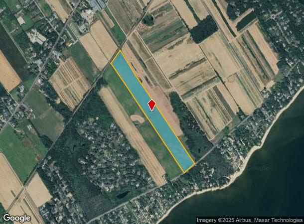
Peconic Bay Blvd
Nassau County-Suffolk County, NY
NX LIRR EX GAJESKI SX PECBAY BLVD W X ZAWESKI
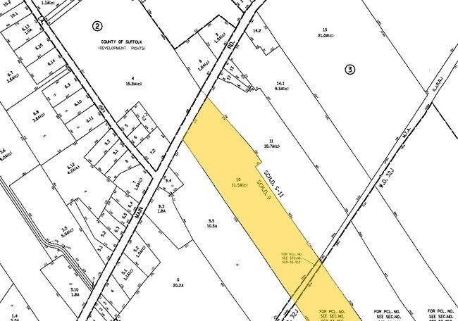
0600-069-00-03-00-057-000
Suffolk
Agriculturalland
New York
X
57
36103C0479H
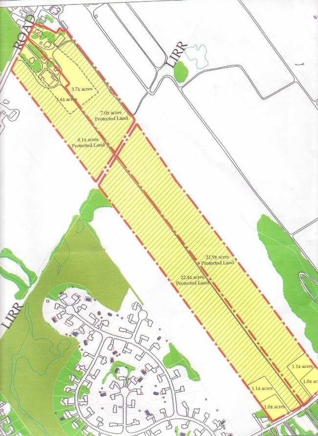
24 AC
2024
Eastern Suffolk
2024
Long Island (New York)
170003
DEMOGRAPHICS near Peconic Bay Blvd
1 Mile
3 Mile
5 Mile
2024 Total Population
994
6,107
22,025
2029 Population
959
6,034
22,020
Pop Growth 2024-2029
(3.52%)
(1.20%)
(0.02%)
Average Age
47
46
43
2024 Total Households
392
2,391
7,967
HH Growth 2024-2029
(4.34%)
(1.63%)
(0.30%)
Median Household Inc
$100,806
$108,138
$100,770
Avg Household Size
2.50
2.50
2.70
2024 Avg HH Vehicles
2.00
2.00
2.00
Median Home Value
$752,024
$751,457
$632,584
Median Year Built
1980
1976
1977
Nearby Places
- Restaurants
- Banks
- Shops
- Fitness
- Groceries
PUBLIC TRANSPORTATION
COMMUTER RAIL
Mattituck Station (Greenport Branch - Long Island Rail Road)
DRIVE
WALK
Distance
Mattituck Station (Greenport Branch - Long Island Rail Road)
10 min
4.6 mi
Freight Ports
Port of New Haven
DRIVE
WALK
Distance
Port of New Haven
161 min
66.3 mi
SALE & LEASE HISTORY
LISTING DATE
SALE/LEASE

May 28, 2019
For Sale
Dec 28, 2018
For Sale
Nearby Properties
Address
Land Use
TOTAL SIZE
Lot Size
Zoning
Address
Land Use
TOTAL SIZE
Lot Size
Zoning
13.29 AC
R80
Address
Land Use
TOTAL SIZE
Lot Size
Zoning
47.30 AC
H2O
Address
Land Use
TOTAL SIZE
Lot Size
Zoning
2.33 AC
R40
Address
Land Use
TOTAL SIZE
Lot Size
Zoning
3,152 SF
1.03 AC
R40
Address
Land Use
TOTAL SIZE
Lot Size
Zoning
19 AC
H2O
Address
Land Use
TOTAL SIZE
Lot Size
Zoning
1,688 SF
34.47 AC
09
Address
Land Use
TOTAL SIZE
Lot Size
Zoning
5.01 AC
10
Address
Land Use
TOTAL SIZE
Lot Size
Zoning
35 AC
H2O
Address
Land Use
TOTAL SIZE
Lot Size
Zoning
5,338 SF
159.30 AC
4
Address
Land Use
TOTAL SIZE
Lot Size
Zoning
1.90 AC
R80
Address
Land Use
TOTAL SIZE
Lot Size
Zoning
1.50 AC
R40
Address
Land Use
TOTAL SIZE
Lot Size
Zoning
11.39 AC
10
Address
Land Use
TOTAL SIZE
Lot Size
Zoning
1,980 SF
63.11 AC
09
Address
Land Use
TOTAL SIZE
Lot Size
Zoning
13,943 SF
4.40 AC
04
Address
Land Use
TOTAL SIZE
Lot Size
Zoning
6,000 SF
3.60 AC
04
Address
Land Use
TOTAL SIZE
Lot Size
Zoning
2,928 SF
85.90 AC
04
Address
Land Use
TOTAL SIZE
Lot Size
Zoning
7.20 AC
H2O
Address
Land Use
TOTAL SIZE
Lot Size
Zoning
10,876 SF
4.80 AC
04
Address
Land Use
TOTAL SIZE
Lot Size
Zoning
0.92 AC
R40
Address
Land Use
TOTAL SIZE
Lot Size
Zoning
2,588 SF
107.80 AC
03
Address
Land Use
TOTAL SIZE
Lot Size
Zoning
8,891 SF
2.91 AC
4
Address
Land Use
TOTAL SIZE
Lot Size
Zoning
24,898 SF
3.80 AC
4
Address
Land Use
TOTAL SIZE
Lot Size
Zoning
392 SF
52.39 AC
09
Address
Land Use
TOTAL SIZE
Lot Size
Zoning
4,487 SF
11.83 AC
03
Address
Land Use
TOTAL SIZE
Lot Size
Zoning
1.50 AC
4
Address
Land Use
TOTAL SIZE
Lot Size
Zoning
2,392 SF
26.20 AC
09
Address
Land Use
TOTAL SIZE
Lot Size
Zoning
2,832 SF
9.23 AC
04
Address
Land Use
TOTAL SIZE
Lot Size
Zoning
12,450 SF
11.65 AC
05
Address
Land Use
TOTAL SIZE
Lot Size
Zoning
4,288 SF
33.20 AC
04
Address
Land Use
TOTAL SIZE
Lot Size
Zoning
4,800 SF
1 AC
RB80
The World's #1 Commercial Real Estate Marketplace
Connect with us
© 2025 CoStar Group
The information above has been obtained from sources believed reliable. While we do not doubt its accuracy we have not verified it and make no guarantee, warranty or representation about it. It is your responsibility to independently confirm its accuracy and completeness. Any projections, opinions, assumptions, or estimates used are for example only and do not represent the current or future performance of the property. The value of this transaction to you depends on tax and other factors which should be evaluated by your tax, financial, and legal advisors. You and your advisors should conduct a careful, independent investigation of the property to determine to your satisfaction the suitability of the property for your needs.