Property Record
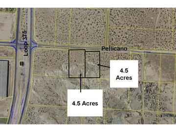
Pellicano Dr, Socorro, TX 79928


Property Detail
Pellicano Dr
El Paso, TX
79 TSP 3 SEC 17 T & P ABST 2154 E 1/2 OF NE 1/4 OF NW 1/4 OF NW 1/4 (EXC NLY 60.00 FT) (4.5455 AC)
X579-000-3170-0580
EL PASO
Commercialnec
Texas
2024
4.55 AC
2025
East
010360
El Paso
NEARBY LISTINGS FOR SALE OR LEASE
DEMOGRAPHICS near Pellicano Dr
1 mile
3 mile
5 mile
2025 Total Population
11,232
81,712
259,102
2030 Population
11,166
83,113
262,191
Pop Growth 2025-2030
(0.59%)
+ 1.71%
+ 1.19%
Average Age
35
35
36
2025 Total Households
3,566
26,306
84,043
HH Growth 2025-2030
(0.39%)
+ 1.69%
+ 1.19%
Median Household Inc
$96,458
$73,064
$69,039
Avg Household Size
3.10
3.10
3.00
2025 Avg HH Vehicles
2.00
2.00
2.00
Median Home Value
$276,391
$229,919
$203,611
Median Year Built
2004
2001
1997
Nearby Places
Map Layers
Map Styles
 Street
 Aerial
Layers
 Traffic
 Biking
Places
Listings with unknown addresses are not visible on the map
- Restaurants
- Banks
- Shops
- Fitness
- Groceries
PUBLIC TRANSPORTATION
AIRPORT
El Paso International
Drive
Walk
Distance
El Paso International
25 min
15.1 mi
Freight Ports
Port of Corpus Christi
Drive
Walk
Distance
Port of Corpus Christi
667 min
682.9 mi
SALE & LEASE HISTORY
LISTING DATE
SALE/LEASE

Feb 15, 2022
For Lease
Nearby Properties
Address
Land Use
TOTAL SIZE
Lot Size
Zoning
Address
Land Use
TOTAL SIZE
Lot Size
Zoning
2,562,545 SF
62.04 AC
Address
Land Use
TOTAL SIZE
Lot Size
Zoning
799,095 SF
52.29 AC
Address
Land Use
TOTAL SIZE
Lot Size
Zoning
555,120 SF
36.68 AC
Address
Land Use
TOTAL SIZE
Lot Size
Zoning
306,059 SF
15.01 AC
C3
Address
Land Use
TOTAL SIZE
Lot Size
Zoning
688,100 SF
33.40 AC
Address
Land Use
TOTAL SIZE
Lot Size
Zoning
260,501 SF
14.05 AC
A2
Address
Land Use
TOTAL SIZE
Lot Size
Zoning
195,977 SF
9.77 AC
C4
Address
Land Use
TOTAL SIZE
Lot Size
Zoning
205,189 SF
22.92 AC
C4
Address
Land Use
TOTAL SIZE
Lot Size
Zoning
463,000 SF
24.75 AC
C4
Address
Land Use
TOTAL SIZE
Lot Size
Zoning
109,039 SF
25.07 AC
Address
Land Use
TOTAL SIZE
Lot Size
Zoning
366,600 SF
21.24 AC
Address
Land Use
TOTAL SIZE
Lot Size
Zoning
80,049 SF
8.90 AC
C4
Address
Land Use
TOTAL SIZE
Lot Size
Zoning
264,803 SF
11.01 AC
Address
Land Use
TOTAL SIZE
Lot Size
Zoning
235,670 SF
10 AC
A3C
Address
Land Use
TOTAL SIZE
Lot Size
Zoning
172,368 SF
10 AC
NZ
Address
Land Use
TOTAL SIZE
Lot Size
Zoning
118,114 SF
13.80 AC
C4S
Address
Land Use
TOTAL SIZE
Lot Size
Zoning
202,253 SF
10.70 AC
A2
Address
Land Use
TOTAL SIZE
Lot Size
Zoning
307,300 SF
17.47 AC
Address
Land Use
TOTAL SIZE
Lot Size
Zoning
321,764 SF
18.61 AC
C4
Address
Land Use
TOTAL SIZE
Lot Size
Zoning
209,006 SF
18.18 AC
C4
Address
Land Use
TOTAL SIZE
Lot Size
Zoning
274,580 SF
13.86 AC
C4S
Address
Land Use
TOTAL SIZE
Lot Size
Zoning
230,152 SF
14.09 AC
C4S
Address
Land Use
TOTAL SIZE
Lot Size
Zoning
192,261 SF
8.07 AC
A3C
Address
Land Use
TOTAL SIZE
Lot Size
Zoning
180,139 SF
24.81 AC
Address
Land Use
TOTAL SIZE
Lot Size
Zoning
269,370 SF
17.88 AC
Address
Land Use
TOTAL SIZE
Lot Size
Zoning
246,136 SF
14.33 AC
Address
Land Use
TOTAL SIZE
Lot Size
Zoning
246,136 SF
15.68 AC
Address
Land Use
TOTAL SIZE
Lot Size
Zoning
110,080 SF
10.36 AC
Address
Land Use
TOTAL SIZE
Lot Size
Zoning
214,346 SF
11.90 AC
The World's #1 Commercial Real Estate Marketplace
Connect with us
© 2026 CoStar Group
The information above has been obtained from sources believed reliable. While we do not doubt its accuracy we have not verified it and make no guarantee, warranty or representation about it. It is your responsibility to independently confirm its accuracy and completeness. Any projections, opinions, assumptions, or estimates used are for example only and do not represent the current or future performance of the property. The value of this transaction to you depends on tax and other factors which should be evaluated by your tax, financial, and legal advisors. You and your advisors should conduct a careful, independent investigation of the property to determine to your satisfaction the suitability of the property for your needs.