Property Record
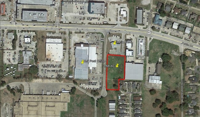
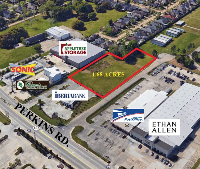
Perkins Rd, Pride, LA 70770

Property Detail
Perkins Rd
Baton Rouge
WARD: 3-0, SUBDIVISION: JUBAN, GAY TRACT, LOT: G-J-1-B-1. TRACT GJ1B-1 CONT. 2.005 ACRES, RESUB. OF TRACT GJ1B OF THE GAY JUBAN PROPERTY IN SEC. 70, T8S,R1E.RESUB. 1982-89-91-07.LESS & EXCEPT PARCEL 18-3 CONT. 0.01 AC TO LADOTD, STATE PROJECT 258-01
Baton Rouge, LA
E BATON ROUGE
01054910
Louisiana
Storesoffices
g-j-
2024
2.01 AC
2024
Essen/Bluebonnet
004700
NEARBY LISTINGS FOR SALE OR LEASE
DEMOGRAPHICS near Perkins Rd
1 mile
3 mile
5 mile
2024 Total Population
9,119
63,407
145,998
2029 Population
9,077
63,274
145,416
Pop Growth 2024-2029
(0.46%)
(0.21%)
(0.40%)
Average Age
43
39
39
2024 Total Households
4,268
27,487
63,088
HH Growth 2024-2029
(0.63%)
(0.27%)
(0.44%)
Median Household Inc
$89,936
$81,556
$77,908
Avg Household Size
2.10
2.30
2.20
2024 Avg HH Vehicles
2.00
2.00
2.00
Median Home Value
$361,900
$323,223
$331,742
Median Year Built
1994
1992
1989
Nearby Places
Map Layers
Map Styles
 Street
 Aerial
Transit
 Traffic
 Biking
Places
Listings with unknown addresses are not visible on the map
- Restaurants
- Banks
- Shops
- Fitness
- Groceries
PUBLIC TRANSPORTATION
AIRPORT
Baton Rouge Metro Ryan Field
Drive
Walk
Distance
Baton Rouge Metro Ryan Field
24 min
16.4 mi
Freight Ports
Port of Greater Baton Rouge
Drive
Walk
Distance
Port of Greater Baton Rouge
19 min
11.6 mi
SALE & LEASE HISTORY
LISTING DATE
SALE/LEASE

Sep 24, 2016
For Sale
Jul 22, 2019
For Sale
Nearby Properties
Address
Land Use
TOTAL SIZE
Lot Size
Zoning
Address
Land Use
TOTAL SIZE
Lot Size
Zoning
937,594 SF
12.50 AC
Address
Land Use
TOTAL SIZE
Lot Size
Zoning
703,858 SF
26.97 AC
Address
Land Use
TOTAL SIZE
Lot Size
Zoning
Address
Land Use
TOTAL SIZE
Lot Size
Zoning
291,999 SF
51.31 AC
Address
Land Use
TOTAL SIZE
Lot Size
Zoning
399,894 SF
37.86 AC
Address
Land Use
TOTAL SIZE
Lot Size
Zoning
Address
Land Use
TOTAL SIZE
Lot Size
Zoning
222,231 SF
236.72 AC
Address
Land Use
TOTAL SIZE
Lot Size
Zoning
14.27 AC
Address
Land Use
TOTAL SIZE
Lot Size
Zoning
10.75 AC
Address
Land Use
TOTAL SIZE
Lot Size
Zoning
234,743 SF
4.69 AC
Address
Land Use
TOTAL SIZE
Lot Size
Zoning
Address
Land Use
TOTAL SIZE
Lot Size
Zoning
Address
Land Use
TOTAL SIZE
Lot Size
Zoning
490,875 SF
12 AC
Address
Land Use
TOTAL SIZE
Lot Size
Zoning
72,023 SF
10.93 AC
Address
Land Use
TOTAL SIZE
Lot Size
Zoning
Address
Land Use
TOTAL SIZE
Lot Size
Zoning
281,736 SF
13.13 AC
Address
Land Use
TOTAL SIZE
Lot Size
Zoning
Address
Land Use
TOTAL SIZE
Lot Size
Zoning
260,000 SF
7.48 AC
Address
Land Use
TOTAL SIZE
Lot Size
Zoning
417,209 SF
4.89 AC
Address
Land Use
TOTAL SIZE
Lot Size
Zoning
291,736 SF
21.28 AC
Address
Land Use
TOTAL SIZE
Lot Size
Zoning
323,903 SF
41.99 AC
Address
Land Use
TOTAL SIZE
Lot Size
Zoning
20.12 AC
Address
Land Use
TOTAL SIZE
Lot Size
Zoning
1.61 AC
Address
Land Use
TOTAL SIZE
Lot Size
Zoning
102,161 SF
0.80 AC
Address
Land Use
TOTAL SIZE
Lot Size
Zoning
Address
Land Use
TOTAL SIZE
Lot Size
Zoning
10.72 AC
Address
Land Use
TOTAL SIZE
Lot Size
Zoning
430,340 SF
16.31 AC
Address
Land Use
TOTAL SIZE
Lot Size
Zoning
362,253 SF
34.85 AC
Address
Land Use
TOTAL SIZE
Lot Size
Zoning
The World's #1 Commercial Real Estate Marketplace
Connect with us
© 2026 CoStar Group
The information above has been obtained from sources believed reliable. While we do not doubt its accuracy we have not verified it and make no guarantee, warranty or representation about it. It is your responsibility to independently confirm its accuracy and completeness. Any projections, opinions, assumptions, or estimates used are for example only and do not represent the current or future performance of the property. The value of this transaction to you depends on tax and other factors which should be evaluated by your tax, financial, and legal advisors. You and your advisors should conduct a careful, independent investigation of the property to determine to your satisfaction the suitability of the property for your needs.