Property Record
550 Phantom Woods Rd, Mukwonago, WI 53149


NEARBY LISTINGS FOR SALE OR LEASE
Property Detail
550 Phantom Woods Rd
Milwaukee-Waukesha, WI
Long Chord Bears
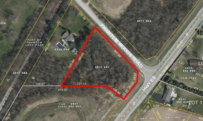
MUKV-2011-984
PT SE1/4 SW1/4 & NW1/4 SEC 35 T5N R18E; COM CTR SEC; E 330 FT; S37 1/2W 1584.00 FT; N44W 561.66 FT; N30E 1098.24 FT; S78 3/4E 483.12 FT TO BGN :: EX PT SW1/4 & SE1/4 SEC 35 T5N R18E COM NW COR SE1/4; S894456E 333.35 FT THE BGN; SWLY 97.82 FT ALG ARC
Commercialnec
Waukesha
X
Wisconsin
55133C0427H
5
2024
17.43 AC
2024
SW/Mukwonago
203901
Milwaukee/Madison
DEMOGRAPHICS near 550 Phantom Woods Rd
1 Mile
3 Mile
5 Mile
2024 Total Population
2,521
15,056
22,011
2029 Population
2,553
15,353
22,337
Pop Growth 2024-2029
+ 1.27%
+ 1.97%
+ 1.48%
Average Age
43
42
42
2024 Total Households
1,089
5,900
8,463
HH Growth 2024-2029
+ 1.29%
+ 1.97%
+ 1.42%
Median Household Inc
$84,764
$94,570
$98,966
Avg Household Size
2.30
2.50
2.60
2024 Avg HH Vehicles
2.00
2.00
2.00
Median Home Value
$278,184
$334,517
$338,653
Median Year Built
1982
1980
1982
Nearby Places
Map Layers
Map Styles
 Street
 Aerial
- Restaurants
- Banks
- Shops
- Fitness
- Groceries
PUBLIC TRANSPORTATION
AIRPORT
General Mitchell International
DRIVE
WALK
Distance
General Mitchell International
37 min
26.5 mi
Freight Ports
Port Milwaukee
DRIVE
WALK
Distance
Port Milwaukee
37 min
28.4 mi
SALE & LEASE HISTORY
LISTING DATE
SALE/LEASE

Oct 24, 2023
For Sale
May 16, 2018
For Sale
Feb 28, 2017
For Sale
Nearby Properties
Address
Land Use
TOTAL SIZE
Lot Size
Zoning
Address
Land Use
TOTAL SIZE
Lot Size
Zoning
15.47 AC
Address
Land Use
TOTAL SIZE
Lot Size
Zoning
15.59 AC
Address
Land Use
TOTAL SIZE
Lot Size
Zoning
21.46 AC
Address
Land Use
TOTAL SIZE
Lot Size
Zoning
4.37 AC
Address
Land Use
TOTAL SIZE
Lot Size
Zoning
15.80 AC
Address
Land Use
TOTAL SIZE
Lot Size
Zoning
14.61 AC
Address
Land Use
TOTAL SIZE
Lot Size
Zoning
41.22 AC
Address
Land Use
TOTAL SIZE
Lot Size
Zoning
10.35 AC
Address
Land Use
TOTAL SIZE
Lot Size
Zoning
12.89 AC
Address
Land Use
TOTAL SIZE
Lot Size
Zoning
12.25 AC
Address
Land Use
TOTAL SIZE
Lot Size
Zoning
10.92 AC
Address
Land Use
TOTAL SIZE
Lot Size
Zoning
11.41 AC
Address
Land Use
TOTAL SIZE
Lot Size
Zoning
Address
Land Use
TOTAL SIZE
Lot Size
Zoning
Address
Land Use
TOTAL SIZE
Lot Size
Zoning
10.97 AC
Address
Land Use
TOTAL SIZE
Lot Size
Zoning
2.32 AC
Address
Land Use
TOTAL SIZE
Lot Size
Zoning
7.50 AC
Address
Land Use
TOTAL SIZE
Lot Size
Zoning
Address
Land Use
TOTAL SIZE
Lot Size
Zoning
4.43 AC
Address
Land Use
TOTAL SIZE
Lot Size
Zoning
9.62 AC
Address
Land Use
TOTAL SIZE
Lot Size
Zoning
3.70 AC
Address
Land Use
TOTAL SIZE
Lot Size
Zoning
3.82 AC
Address
Land Use
TOTAL SIZE
Lot Size
Zoning
Address
Land Use
TOTAL SIZE
Lot Size
Zoning
2.99 AC
Address
Land Use
TOTAL SIZE
Lot Size
Zoning
Address
Land Use
TOTAL SIZE
Lot Size
Zoning
Address
Land Use
TOTAL SIZE
Lot Size
Zoning
The World's #1 Commercial Real Estate Marketplace
Connect with us
© 2026 CoStar Group
The information above has been obtained from sources believed reliable. While we do not doubt its accuracy we have not verified it and make no guarantee, warranty or representation about it. It is your responsibility to independently confirm its accuracy and completeness. Any projections, opinions, assumptions, or estimates used are for example only and do not represent the current or future performance of the property. The value of this transaction to you depends on tax and other factors which should be evaluated by your tax, financial, and legal advisors. You and your advisors should conduct a careful, independent investigation of the property to determine to your satisfaction the suitability of the property for your needs.