Property Record
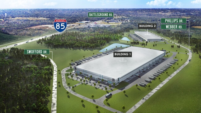
Phillips Dr, Cowpens, SC 29330

Current Lease Availabilities
Property Detail
Phillips Dr
Spartanburg, SC
P/O TRACT B WADE H LINDSEY SURVEY PB 76/210-212 DB 43K-413 01-07-76
3-04-00-032.01
SPARTANBURG
Agriculturalland
South Carolina
B and X Area of moderate flood hazard, usually the area between the limits of the 100-year and 500-year floods.
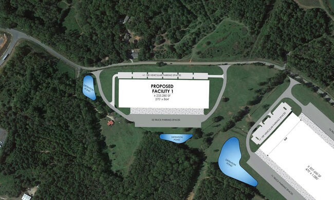
20.65 AC
2024
Upper Spartanburg Cty
2025
Greenville/Spartanburg
970102
NEARBY LISTINGS FOR SALE OR LEASE
DEMOGRAPHICS near Phillips Dr
1 mile
3 mile
5 mile
2025 Total Population
368
5,853
19,076
2030 Population
407
6,437
20,936
Pop Growth 2025-2030
+ 10.60%
+ 9.98%
+ 9.75%
Average Age
40
41
41
2025 Total Households
145
2,342
7,563
HH Growth 2025-2030
+ 11.03%
+ 10.12%
+ 9.85%
Median Household Inc
$46,500
$49,509
$58,567
Avg Household Size
2.50
2.50
2.50
2025 Avg HH Vehicles
2.00
2.00
2.00
Median Home Value
$171,621
$193,641
$202,410
Median Year Built
1983
1980
1985
Nearby Places
Map Layers
Map Styles
 Street
 Aerial
Layers
 Traffic
 Biking
Places
Listings with unknown addresses are not visible on the map
- Restaurants
- Banks
- Shops
- Fitness
- Groceries
PUBLIC TRANSPORTATION
AIRPORT
Greenville Spartanburg International
Drive
Walk
Distance
Greenville Spartanburg International
38 min
28.8 mi
Freight Ports
North Charleston Terminal
Drive
Walk
Distance
North Charleston Terminal
234 min
209.3 mi
Nearby Properties
Address
Land Use
TOTAL SIZE
Lot Size
Zoning
Address
Land Use
TOTAL SIZE
Lot Size
Zoning
73.03 AC
Address
Land Use
TOTAL SIZE
Lot Size
Zoning
17,150 SF
5 AC
Address
Land Use
TOTAL SIZE
Lot Size
Zoning
42.36 AC
Address
Land Use
TOTAL SIZE
Lot Size
Zoning
110.93 AC
Address
Land Use
TOTAL SIZE
Lot Size
Zoning
27.76 AC
Address
Land Use
TOTAL SIZE
Lot Size
Zoning
30.70 AC
Address
Land Use
TOTAL SIZE
Lot Size
Zoning
3,300 SF
11.44 AC
Address
Land Use
TOTAL SIZE
Lot Size
Zoning
3,731 SF
0.81 AC
Address
Land Use
TOTAL SIZE
Lot Size
Zoning
319,564 SF
39.43 AC
Address
Land Use
TOTAL SIZE
Lot Size
Zoning
23.87 AC
Address
Land Use
TOTAL SIZE
Lot Size
Zoning
93.78 AC
Address
Land Use
TOTAL SIZE
Lot Size
Zoning
454 SF
106.59 AC
Address
Land Use
TOTAL SIZE
Lot Size
Zoning
58,986 SF
23.37 AC
Address
Land Use
TOTAL SIZE
Lot Size
Zoning
100,000 SF
7.45 AC
Address
Land Use
TOTAL SIZE
Lot Size
Zoning
2,400 SF
1.21 AC
Address
Land Use
TOTAL SIZE
Lot Size
Zoning
3,688 SF
0.88 AC
Address
Land Use
TOTAL SIZE
Lot Size
Zoning
2,400 SF
Address
Land Use
TOTAL SIZE
Lot Size
Zoning
21.54 AC
Address
Land Use
TOTAL SIZE
Lot Size
Zoning
14.67 AC
Address
Land Use
TOTAL SIZE
Lot Size
Zoning
1,912 SF
0.32 AC
Address
Land Use
TOTAL SIZE
Lot Size
Zoning
5,130 SF
0.65 AC
Address
Land Use
TOTAL SIZE
Lot Size
Zoning
2,744 SF
2 AC
Address
Land Use
TOTAL SIZE
Lot Size
Zoning
1,764 SF
0.62 AC
Address
Land Use
TOTAL SIZE
Lot Size
Zoning
39.95 AC
Address
Land Use
TOTAL SIZE
Lot Size
Zoning
Address
Land Use
TOTAL SIZE
Lot Size
Zoning
22.97 AC
Address
Land Use
TOTAL SIZE
Lot Size
Zoning
11,154 SF
2.17 AC
Address
Land Use
TOTAL SIZE
Lot Size
Zoning
2,932 SF
1.75 AC
Address
Land Use
TOTAL SIZE
Lot Size
Zoning
1,650 SF
0.52 AC
Address
Land Use
TOTAL SIZE
Lot Size
Zoning
1,371 SF
1.83 AC
The World's #1 Commercial Real Estate Marketplace
Connect with us
© 2026 CoStar Group
The information above has been obtained from sources believed reliable. While we do not doubt its accuracy we have not verified it and make no guarantee, warranty or representation about it. It is your responsibility to independently confirm its accuracy and completeness. Any projections, opinions, assumptions, or estimates used are for example only and do not represent the current or future performance of the property. The value of this transaction to you depends on tax and other factors which should be evaluated by your tax, financial, and legal advisors. You and your advisors should conduct a careful, independent investigation of the property to determine to your satisfaction the suitability of the property for your needs.