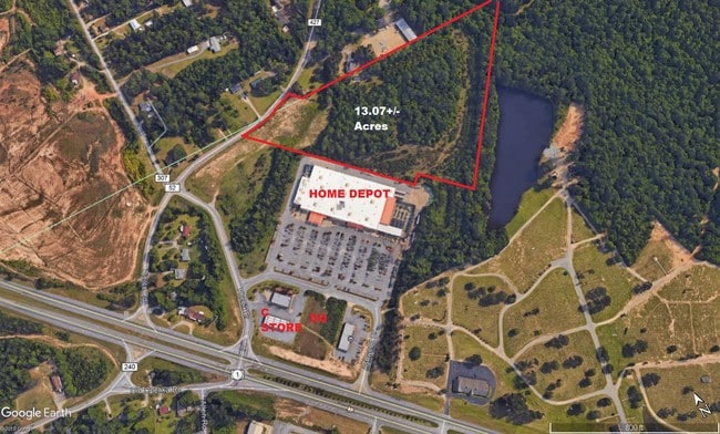
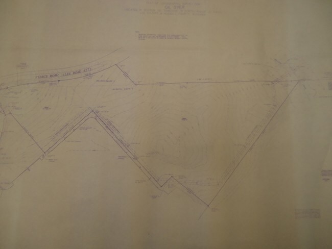
Property Record
Pierce Rd E, Phenix City, AL 36870

Property Detail
Pierce Rd E
01-09-32-04-001-001.004
S32T18R30 TR-1 OF HOME DEPOT USA INC PLAT (I-89) BEG NW COR SE1/4 SEC-32 S360 SE85 NE372 NW212 W TO PB
Warehouse
RUSSELL
O
Alabama
AE The base floodplain where base flood elevations are provided. AE Zones are now used on new format FIRMs instead of A1-A30 Zones.
13 AC
2025
Phenix City
2025
Columbus GA
030401
Columbus, GA-AL
1,800 SF
NEARBY LISTINGS FOR SALE OR LEASE
DEMOGRAPHICS near Pierce Rd E
1 mile
3 mile
5 mile
2025 Total Population
3,911
30,294
86,609
2030 Population
4,093
31,165
87,974
Pop Growth 2025-2030
+ 4.65%
+ 2.88%
+ 1.58%
Average Age
41
39
39
2025 Total Households
1,565
12,304
35,209
HH Growth 2025-2030
+ 4.66%
+ 2.75%
+ 1.69%
Median Household Inc
$71,631
$66,103
$55,039
Avg Household Size
2.50
2.40
2.40
2025 Avg HH Vehicles
2.00
2.00
2.00
Median Home Value
$239,812
$227,314
$200,305
Median Year Built
1994
1993
1985
Nearby Places
Map Layers
Map Styles
 Street
 Aerial
Layers
 Traffic
 Biking
Places
Listings with unknown addresses are not visible on the map
- Restaurants
- Banks
- Shops
- Fitness
- Groceries
PUBLIC TRANSPORTATION
AIRPORT
Columbus
Drive
Walk
Distance
Columbus
17 min
9.6 mi
Freight Ports
Port of Panama City
Drive
Walk
Distance
Port of Panama City
236 min
186.7 mi
SALE & LEASE HISTORY
LISTING DATE
SALE/LEASE

Sep 24, 2016
For Sale
Aug 22, 2017
For Sale
Nearby Properties
Address
Land Use
TOTAL SIZE
Lot Size
Zoning
Address
Land Use
TOTAL SIZE
Lot Size
Zoning
64,793 SF
34.48 AC
Address
Land Use
TOTAL SIZE
Lot Size
Zoning
Address
Land Use
TOTAL SIZE
Lot Size
Zoning
24.20 AC
Address
Land Use
TOTAL SIZE
Lot Size
Zoning
21,584 SF
28.11 AC
Address
Land Use
TOTAL SIZE
Lot Size
Zoning
23,488 SF
26 AC
Address
Land Use
TOTAL SIZE
Lot Size
Zoning
17,000 SF
6 AC
O
Address
Land Use
TOTAL SIZE
Lot Size
Zoning
24,094 SF
8 AC
O
Address
Land Use
TOTAL SIZE
Lot Size
Zoning
11,124 SF
5 AC
Address
Land Use
TOTAL SIZE
Lot Size
Zoning
58,094 SF
8.27 AC
Address
Land Use
TOTAL SIZE
Lot Size
Zoning
30,120 SF
7 AC
Address
Land Use
TOTAL SIZE
Lot Size
Zoning
43,056 SF
4 AC
O
Address
Land Use
TOTAL SIZE
Lot Size
Zoning
9,506 SF
15 AC
O
Address
Land Use
TOTAL SIZE
Lot Size
Zoning
10,160 SF
16.26 AC
O
Address
Land Use
TOTAL SIZE
Lot Size
Zoning
57,826 SF
7 AC
O
Address
Land Use
TOTAL SIZE
Lot Size
Zoning
3,420 SF
16 AC
O
Address
Land Use
TOTAL SIZE
Lot Size
Zoning
11,768 SF
16.80 AC
Address
Land Use
TOTAL SIZE
Lot Size
Zoning
3,150 SF
2.39 AC
O
Address
Land Use
TOTAL SIZE
Lot Size
Zoning
10,672 SF
5.55 AC
Address
Land Use
TOTAL SIZE
Lot Size
Zoning
9,000 SF
2.40 AC
Address
Land Use
TOTAL SIZE
Lot Size
Zoning
2,816 SF
6 AC
O
Address
Land Use
TOTAL SIZE
Lot Size
Zoning
104,950 SF
6 AC
C
Address
Land Use
TOTAL SIZE
Lot Size
Zoning
9,000 SF
10 AC
O
Address
Land Use
TOTAL SIZE
Lot Size
Zoning
81,850 SF
7 AC
O
Address
Land Use
TOTAL SIZE
Lot Size
Zoning
73,270 SF
4.41 AC
O
Address
Land Use
TOTAL SIZE
Lot Size
Zoning
Address
Land Use
TOTAL SIZE
Lot Size
Zoning
50,000 SF
5 AC
O
Address
Land Use
TOTAL SIZE
Lot Size
Zoning
122,139 SF
10 AC
The World's #1 Commercial Real Estate Marketplace
Connect with us
© 2026 CoStar Group
The information above has been obtained from sources believed reliable. While we do not doubt its accuracy we have not verified it and make no guarantee, warranty or representation about it. It is your responsibility to independently confirm its accuracy and completeness. Any projections, opinions, assumptions, or estimates used are for example only and do not represent the current or future performance of the property. The value of this transaction to you depends on tax and other factors which should be evaluated by your tax, financial, and legal advisors. You and your advisors should conduct a careful, independent investigation of the property to determine to your satisfaction the suitability of the property for your needs.