Property Record
Pike Rd, Sackets Harbor, NY 13685


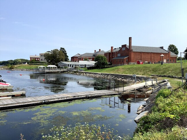
Property Detail
Pike Rd
Watertown-Fort Drum, NY
JEFFERSON
223801-081-077-0001-001-192
New York
Marinafacility
1.192
2025
1.33 AC
2025
Central New York Area/Thousand Island
060402
Other Market Areas
NEARBY LISTINGS FOR SALE OR LEASE
-
-
View all Sackets Harbor listings for sale on LoopNet.com
DEMOGRAPHICS near Pike Rd
1 mile
3 mile
5 mile
2025 Total Population
1,268
2,297
4,379
2030 Population
1,258
2,293
4,372
Pop Growth 2025-2030
(0.79%)
(0.17%)
(0.16%)
Average Age
42
43
43
2025 Total Households
597
1,058
1,981
HH Growth 2025-2030
(1.51%)
(0.85%)
(0.81%)
Median Household Inc
$88,917
$87,111
$80,045
Avg Household Size
2.10
2.10
2.20
2025 Avg HH Vehicles
2.00
2.00
2.00
Median Home Value
$325,000
$304,375
$269,963
Median Year Built
1975
1975
1976
Nearby Places
Map Layers
Map Styles
 Street
 Aerial
Layers
 Traffic
 Biking
Places
Listings with unknown addresses are not visible on the map
- Restaurants
- Banks
- Shops
- Fitness
- Groceries
SALE & LEASE HISTORY
LISTING DATE
SALE/LEASE

Mar 01, 2022
For Sale
Nearby Properties
Address
Land Use
TOTAL SIZE
Lot Size
Zoning
Address
Land Use
TOTAL SIZE
Lot Size
Zoning
6,150 SF
8.31 AC
Address
Land Use
TOTAL SIZE
Lot Size
Zoning
51,121 SF
24.90 AC
07 - MIXED
Address
Land Use
TOTAL SIZE
Lot Size
Zoning
13,790 SF
5.74 AC
Address
Land Use
TOTAL SIZE
Lot Size
Zoning
960 SF
3.33 AC
Address
Land Use
TOTAL SIZE
Lot Size
Zoning
4,500 SF
4.77 AC
Address
Land Use
TOTAL SIZE
Lot Size
Zoning
4,680 SF
2.46 AC
Address
Land Use
TOTAL SIZE
Lot Size
Zoning
9,220 SF
3.57 AC
Address
Land Use
TOTAL SIZE
Lot Size
Zoning
3,060 SF
1.23 AC
Address
Land Use
TOTAL SIZE
Lot Size
Zoning
2,226 SF
62.80 AC
Address
Land Use
TOTAL SIZE
Lot Size
Zoning
Address
Land Use
TOTAL SIZE
Lot Size
Zoning
7,920 SF
2.22 AC
07 - MIXED
Address
Land Use
TOTAL SIZE
Lot Size
Zoning
15,150 SF
0.39 AC
Address
Land Use
TOTAL SIZE
Lot Size
Zoning
8,064 SF
1.16 AC
Address
Land Use
TOTAL SIZE
Lot Size
Zoning
14,097 SF
0.30 AC
07 - MIXED
Address
Land Use
TOTAL SIZE
Lot Size
Zoning
13,800 SF
0.96 AC
Address
Land Use
TOTAL SIZE
Lot Size
Zoning
7,715 SF
0.91 AC
07 - MIXED
Address
Land Use
TOTAL SIZE
Lot Size
Zoning
7,626 SF
3.21 AC
07 - MIXED
Address
Land Use
TOTAL SIZE
Lot Size
Zoning
13,494 SF
5 AC
07 - MIXED
Address
Land Use
TOTAL SIZE
Lot Size
Zoning
7,780 SF
0.58 AC
Address
Land Use
TOTAL SIZE
Lot Size
Zoning
6,348 SF
0.90 AC
07 - MIXED
Address
Land Use
TOTAL SIZE
Lot Size
Zoning
9,642 SF
2.34 AC
Address
Land Use
TOTAL SIZE
Lot Size
Zoning
3,000 SF
5.06 AC
Address
Land Use
TOTAL SIZE
Lot Size
Zoning
200 SF
1 AC
Address
Land Use
TOTAL SIZE
Lot Size
Zoning
Address
Land Use
TOTAL SIZE
Lot Size
Zoning
3,920 SF
0.84 AC
Address
Land Use
TOTAL SIZE
Lot Size
Zoning
19,440 SF
0.72 AC
Address
Land Use
TOTAL SIZE
Lot Size
Zoning
5,032 SF
0.22 AC
Address
Land Use
TOTAL SIZE
Lot Size
Zoning
12,960 SF
0.90 AC
Address
Land Use
TOTAL SIZE
Lot Size
Zoning
5,856 SF
0.19 AC
The World's #1 Commercial Real Estate Marketplace
Connect with us
© 2026 CoStar Group
The information above has been obtained from sources believed reliable. While we do not doubt its accuracy we have not verified it and make no guarantee, warranty or representation about it. It is your responsibility to independently confirm its accuracy and completeness. Any projections, opinions, assumptions, or estimates used are for example only and do not represent the current or future performance of the property. The value of this transaction to you depends on tax and other factors which should be evaluated by your tax, financial, and legal advisors. You and your advisors should conduct a careful, independent investigation of the property to determine to your satisfaction the suitability of the property for your needs.