Property Record
186 Pinebrook Rd, Eatontown, NJ 07724
NEARBY LISTINGS FOR SALE OR LEASE
Property Detail
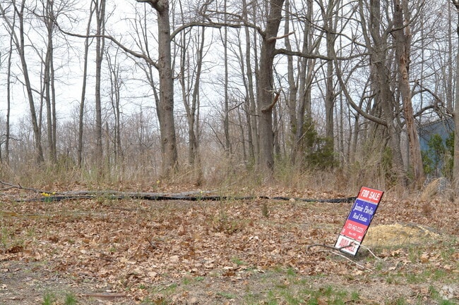
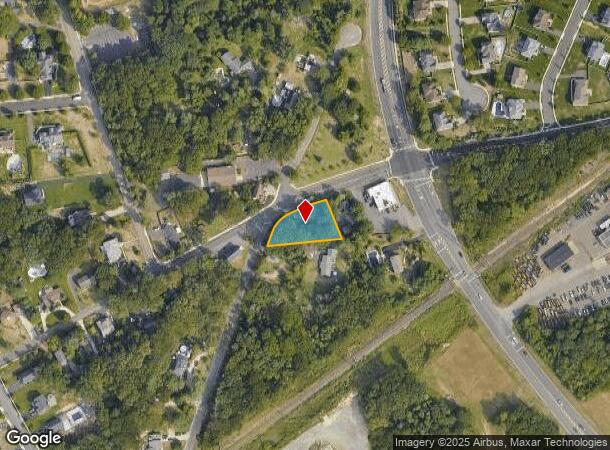
186 Pinebrook Rd
49-00108-0000-00001-02
Monmouth
Vacantlandnec
New Jersey
X
1.2
34025C0186F
0.67 AC
2024
Eastern Monmouth
2025
Northern New Jersey
804600
New York-Jersey City-White Plains, NY-NJ
DEMOGRAPHICS near 186 Pinebrook Rd
1 Mile
3 Mile
5 Mile
2024 Total Population
2,887
33,688
116,105
2029 Population
2,841
33,302
115,269
Pop Growth 2024-2029
(1.59%)
(1.15%)
(0.72%)
Average Age
43
43
43
2024 Total Households
1,127
13,918
45,262
HH Growth 2024-2029
(2.13%)
(1.53%)
(1.09%)
Median Household Inc
$113,858
$98,251
$106,124
Avg Household Size
2.50
2.40
2.50
2024 Avg HH Vehicles
2.00
2.00
2.00
Median Home Value
$608,961
$486,984
$536,401
Median Year Built
1984
1981
1974
Nearby Places
- Restaurants
- Banks
- Shops
- Fitness
- Groceries
PUBLIC TRANSPORTATION
COMMUTER RAIL
Little Silver (North Jersey Coast Line - NJ Transit Commuter Rail (NJ Transit))
DRIVE
WALK
Distance
Little Silver (North Jersey Coast Line - NJ Transit Commuter Rail (NJ Transit))
9 min
5.2 mi
Red Bank (North Jersey Coast Line - NJ Transit Commuter Rail (NJ Transit))
DRIVE
WALK
Distance
Red Bank (North Jersey Coast Line - NJ Transit Commuter Rail (NJ Transit))
11 min
6.1 mi
AIRPORT
Newark Liberty International
DRIVE
WALK
Distance
Newark Liberty International
54 min
43.6 mi
Freight Ports
New York Container Terminal
DRIVE
WALK
Distance
New York Container Terminal
48 min
35.7 mi
Nearby Properties
Address
Land Use
TOTAL SIZE
Lot Size
Zoning
Address
Land Use
TOTAL SIZE
Lot Size
Zoning
221.56 AC
P1
Address
Land Use
TOTAL SIZE
Lot Size
Zoning
75.16 AC
R-7
Address
Land Use
TOTAL SIZE
Lot Size
Zoning
134,075 SF
339.89 AC
OSGS
Address
Land Use
TOTAL SIZE
Lot Size
Zoning
Address
Land Use
TOTAL SIZE
Lot Size
Zoning
1,100 SF
37.83 AC
C-2
Address
Land Use
TOTAL SIZE
Lot Size
Zoning
24.45 AC
R10A
Address
Land Use
TOTAL SIZE
Lot Size
Zoning
35.98 AC
R10A
Address
Land Use
TOTAL SIZE
Lot Size
Zoning
178,315 SF
24.54 AC
3713
Address
Land Use
TOTAL SIZE
Lot Size
Zoning
27 AC
R10A
Address
Land Use
TOTAL SIZE
Lot Size
Zoning
201,455 SF
79.34 AC
R-1
Address
Land Use
TOTAL SIZE
Lot Size
Zoning
20.62 AC
AR3P
Address
Land Use
TOTAL SIZE
Lot Size
Zoning
153,160 SF
10.12 AC
BP2
Address
Land Use
TOTAL SIZE
Lot Size
Zoning
181,867 SF
31.90 AC
RA
Address
Land Use
TOTAL SIZE
Lot Size
Zoning
258,088 SF
27.90 AC
IO20
Address
Land Use
TOTAL SIZE
Lot Size
Zoning
14.99 AC
R10A
Address
Land Use
TOTAL SIZE
Lot Size
Zoning
132,378 SF
8.10 AC
OB01
Address
Land Use
TOTAL SIZE
Lot Size
Zoning
14.73 AC
MF08
Address
Land Use
TOTAL SIZE
Lot Size
Zoning
36.22 AC
P1
Address
Land Use
TOTAL SIZE
Lot Size
Zoning
101,700 SF
0.01 AC
BP2
Address
Land Use
TOTAL SIZE
Lot Size
Zoning
86,586 SF
4.83 AC
R-4
Address
Land Use
TOTAL SIZE
Lot Size
Zoning
89,775 SF
7.05 AC
PBO
Address
Land Use
TOTAL SIZE
Lot Size
Zoning
10,473 SF
214.74 AC
AGCL
Address
Land Use
TOTAL SIZE
Lot Size
Zoning
30,000 SF
10.03 AC
LI
Address
Land Use
TOTAL SIZE
Lot Size
Zoning
187,252 SF
10 AC
OB0
Address
Land Use
TOTAL SIZE
Lot Size
Zoning
260,260 SF
2.36 AC
MURC
Address
Land Use
TOTAL SIZE
Lot Size
Zoning
23,296 SF
3.07 AC
B2
Address
Land Use
TOTAL SIZE
Lot Size
Zoning
8.99 AC
R20
Address
Land Use
TOTAL SIZE
Lot Size
Zoning
11.18 AC
9408
Address
Land Use
TOTAL SIZE
Lot Size
Zoning
99,492 SF
0.03 AC
B6
Address
Land Use
TOTAL SIZE
Lot Size
Zoning
68,215 SF
9.13 AC
B6
The World's #1 Commercial Real Estate Marketplace
Connect with us
© 2025 CoStar Group
The information above has been obtained from sources believed reliable. While we do not doubt its accuracy we have not verified it and make no guarantee, warranty or representation about it. It is your responsibility to independently confirm its accuracy and completeness. Any projections, opinions, assumptions, or estimates used are for example only and do not represent the current or future performance of the property. The value of this transaction to you depends on tax and other factors which should be evaluated by your tax, financial, and legal advisors. You and your advisors should conduct a careful, independent investigation of the property to determine to your satisfaction the suitability of the property for your needs.