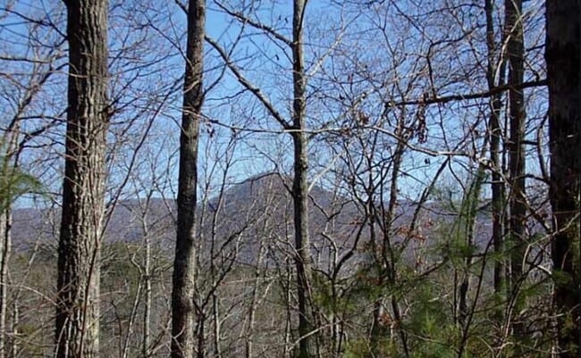
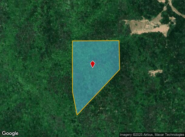
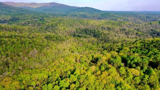
Property Record
Pine Crest Rd, Jasper, GA 30143
NEARBY LISTINGS FOR SALE OR LEASE
Property Detail
Pine Crest Rd
023-000-085-000
DIST5 LL252 94.37AC
Agriculturalland
Pickens
A
Georgia
13057C0075E
94.37 AC
2024
Pickens County
2024
Atlanta
050202
Atlanta-Sandy Springs-Roswell, GA
DEMOGRAPHICS near Pine Crest Rd
1 Mile
3 Mile
5 Mile
2024 Total Population
310
8,309
16,207
2029 Population
344
9,294
18,130
Pop Growth 2024-2029
+ 10.97%
+ 11.85%
+ 11.87%
Average Age
44
44
44
2024 Total Households
125
3,366
6,496
HH Growth 2024-2029
+ 10.40%
+ 11.59%
+ 11.59%
Median Household Inc
$60,625
$69,394
$70,631
Avg Household Size
2.40
2.40
2.40
2024 Avg HH Vehicles
2.00
2.00
2.00
Median Home Value
$279,411
$239,046
$263,449
Median Year Built
1992
1990
1992
Nearby Places
- Restaurants
- Banks
- Shops
- Fitness
- Groceries
SALE & LEASE HISTORY
LISTING DATE
SALE/LEASE

May 24, 2021
For Sale
Nearby Properties
Address
Land Use
TOTAL SIZE
Lot Size
Zoning
Address
Land Use
TOTAL SIZE
Lot Size
Zoning
40,482 SF
1.84 AC
CBD
Address
Land Use
TOTAL SIZE
Lot Size
Zoning
2,016 SF
647 AC
HB
Address
Land Use
TOTAL SIZE
Lot Size
Zoning
66,768 SF
19.43 AC
R-1
Address
Land Use
TOTAL SIZE
Lot Size
Zoning
9,120 SF
12.06 AC
R-1
Address
Land Use
TOTAL SIZE
Lot Size
Zoning
19,541 SF
3.12 AC
C-1
Address
Land Use
TOTAL SIZE
Lot Size
Zoning
9,670 SF
9.73 AC
C-2
Address
Land Use
TOTAL SIZE
Lot Size
Zoning
20,461 SF
3.71 AC
M-1
Address
Land Use
TOTAL SIZE
Lot Size
Zoning
5,928 SF
5 AC
M-1
Address
Land Use
TOTAL SIZE
Lot Size
Zoning
22,360 SF
28.31 AC
M-1
Address
Land Use
TOTAL SIZE
Lot Size
Zoning
14,736 SF
2.32 AC
CBD
Address
Land Use
TOTAL SIZE
Lot Size
Zoning
63,947 SF
10.38 AC
M-1
Address
Land Use
TOTAL SIZE
Lot Size
Zoning
5,880 SF
5.67 AC
R-3
Address
Land Use
TOTAL SIZE
Lot Size
Zoning
13,078 SF
1.32 AC
CBD
Address
Land Use
TOTAL SIZE
Lot Size
Zoning
21,740 SF
7.31 AC
C-2
Address
Land Use
TOTAL SIZE
Lot Size
Zoning
5,248 SF
9.53 AC
R-1
Address
Land Use
TOTAL SIZE
Lot Size
Zoning
5,952 SF
3.45 AC
R-3
Address
Land Use
TOTAL SIZE
Lot Size
Zoning
31,925 SF
5.69 AC
C-2
Address
Land Use
TOTAL SIZE
Lot Size
Zoning
27,014 SF
5.76 AC
C-2
Address
Land Use
TOTAL SIZE
Lot Size
Zoning
42,215 SF
14.32 AC
C-2
Address
Land Use
TOTAL SIZE
Lot Size
Zoning
8,910 SF
1.66 AC
C-1
Address
Land Use
TOTAL SIZE
Lot Size
Zoning
23,495 SF
4.20 AC
C-2
Address
Land Use
TOTAL SIZE
Lot Size
Zoning
5,448 SF
30.17 AC
HB
Address
Land Use
TOTAL SIZE
Lot Size
Zoning
20,000 SF
4.02 AC
M-1
Address
Land Use
TOTAL SIZE
Lot Size
Zoning
15,275 SF
1.54 AC
CBD
Address
Land Use
TOTAL SIZE
Lot Size
Zoning
12,416 SF
3.17 AC
R-3
Address
Land Use
TOTAL SIZE
Lot Size
Zoning
16,500 SF
3.81 AC
HB
Address
Land Use
TOTAL SIZE
Lot Size
Zoning
29,200 SF
4.43 AC
M-1
Address
Land Use
TOTAL SIZE
Lot Size
Zoning
4,412 SF
4.48 AC
R-3
Address
Land Use
TOTAL SIZE
Lot Size
Zoning
33,698 SF
5 AC
HB
Address
Land Use
TOTAL SIZE
Lot Size
Zoning
11,830 SF
1.38 AC
C-2
The World's #1 Commercial Real Estate Marketplace
Connect with us
© 2025 CoStar Group
The information above has been obtained from sources believed reliable. While we do not doubt its accuracy we have not verified it and make no guarantee, warranty or representation about it. It is your responsibility to independently confirm its accuracy and completeness. Any projections, opinions, assumptions, or estimates used are for example only and do not represent the current or future performance of the property. The value of this transaction to you depends on tax and other factors which should be evaluated by your tax, financial, and legal advisors. You and your advisors should conduct a careful, independent investigation of the property to determine to your satisfaction the suitability of the property for your needs.