Property Record
1055 Research Center Dr, Ridgeville, SC 29472
NEARBY LISTINGS FOR SALE OR LEASE
-
-
View all Ridgeville listings for sale on LoopNet.com
Property Detail
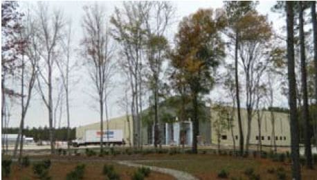
1055 Research Center Dr
Charleston-North Charleston, SC
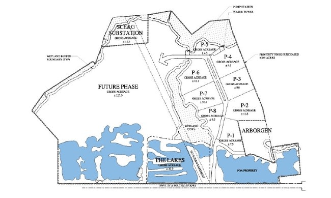
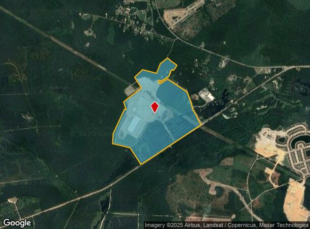
A Plat Of The Re Survey Of Tract 1 Tms 1
150-00-00-199
TRACT 1
Commercialnec
Dorchester
AE
South Carolina
45035C0383E
308.23 AC
2025
Dorchester County
2025
Charleston/N Charleston
010400
DEMOGRAPHICS near 1055 Research Center Dr
1 Mile
3 Mile
5 Mile
2024 Total Population
227
5,797
25,969
2029 Population
249
6,459
28,420
Pop Growth 2024-2029
+ 9.69%
+ 11.42%
+ 9.44%
Average Age
41
40
38
2024 Total Households
82
2,044
9,093
HH Growth 2024-2029
+ 8.54%
+ 11.20%
+ 9.20%
Median Household Inc
$81,000
$101,706
$92,967
Avg Household Size
2.60
2.80
2.80
2024 Avg HH Vehicles
2.00
2.00
2.00
Median Home Value
$373,333
$365,199
$328,507
Median Year Built
1993
2010
2004
Nearby Places
- Restaurants
- Banks
- Shops
- Fitness
- Groceries
PUBLIC TRANSPORTATION
AIRPORT
Charleston AFB/International
DRIVE
WALK
Distance
Charleston AFB/International
23 min
17.5 mi
Freight Ports
North Charleston Terminal
DRIVE
WALK
Distance
North Charleston Terminal
31 min
22.4 mi
SALE & LEASE HISTORY
LISTING DATE
SALE/LEASE

Sep 24, 2016
For Sale
Nearby Properties
Address
Land Use
TOTAL SIZE
Lot Size
Zoning
Address
Land Use
TOTAL SIZE
Lot Size
Zoning
1,796.72 AC
EE
Address
Land Use
TOTAL SIZE
Lot Size
Zoning
15 AC
MUC_DC
Address
Land Use
TOTAL SIZE
Lot Size
Zoning
2,421.68 AC
EE
Address
Land Use
TOTAL SIZE
Lot Size
Zoning
3,096.70 AC
EE
Address
Land Use
TOTAL SIZE
Lot Size
Zoning
59,600 SF
13.50 AC
I_DC
Address
Land Use
TOTAL SIZE
Lot Size
Zoning
294.44 AC
EE
Address
Land Use
TOTAL SIZE
Lot Size
Zoning
291.05 AC
MUC_DC
Address
Land Use
TOTAL SIZE
Lot Size
Zoning
119.14 AC
EE
Address
Land Use
TOTAL SIZE
Lot Size
Zoning
187.73 AC
EE
Address
Land Use
TOTAL SIZE
Lot Size
Zoning
1,079.42 AC
EE
Address
Land Use
TOTAL SIZE
Lot Size
Zoning
35.94 AC
I_DC
Address
Land Use
TOTAL SIZE
Lot Size
Zoning
672 SF
84.91 AC
MUC_DC
Address
Land Use
TOTAL SIZE
Lot Size
Zoning
486.45 AC
AR_DC
Address
Land Use
TOTAL SIZE
Lot Size
Zoning
118.24 AC
AR_DC
Address
Land Use
TOTAL SIZE
Lot Size
Zoning
836.14 AC
AR_DC
Address
Land Use
TOTAL SIZE
Lot Size
Zoning
47.13 AC
EE
Address
Land Use
TOTAL SIZE
Lot Size
Zoning
838.54 AC
AR_DC
Address
Land Use
TOTAL SIZE
Lot Size
Zoning
552 SF
79.26 AC
EE
Address
Land Use
TOTAL SIZE
Lot Size
Zoning
125.05 AC
EE
Address
Land Use
TOTAL SIZE
Lot Size
Zoning
79.40 AC
TRM_DC
Address
Land Use
TOTAL SIZE
Lot Size
Zoning
819.38 AC
AR_DC
Address
Land Use
TOTAL SIZE
Lot Size
Zoning
100 AC
TRM_DC
Address
Land Use
TOTAL SIZE
Lot Size
Zoning
62.98 AC
PD_DC
Address
Land Use
TOTAL SIZE
Lot Size
Zoning
21.43 AC
EE
Address
Land Use
TOTAL SIZE
Lot Size
Zoning
10 AC
MUC_DC
Address
Land Use
TOTAL SIZE
Lot Size
Zoning
7,210 SF
73.50 AC
MUC_DC
Address
Land Use
TOTAL SIZE
Lot Size
Zoning
50.10 AC
AR_DC
Address
Land Use
TOTAL SIZE
Lot Size
Zoning
115.77 AC
CG_DC
Address
Land Use
TOTAL SIZE
Lot Size
Zoning
1,072 SF
85.63 AC
EE
The World's #1 Commercial Real Estate Marketplace
Connect with us
© 2025 CoStar Group
The information above has been obtained from sources believed reliable. While we do not doubt its accuracy we have not verified it and make no guarantee, warranty or representation about it. It is your responsibility to independently confirm its accuracy and completeness. Any projections, opinions, assumptions, or estimates used are for example only and do not represent the current or future performance of the property. The value of this transaction to you depends on tax and other factors which should be evaluated by your tax, financial, and legal advisors. You and your advisors should conduct a careful, independent investigation of the property to determine to your satisfaction the suitability of the property for your needs.