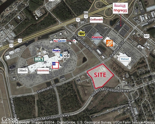
Property Record
Pine Island Rd, Myrtle Beach, SC 29577

Property Detail
Pine Island Rd
Myrtle Beach-Conway-North Myrtle Beach, SC
PARCEL A,B,C,D
42500000312
HORRY
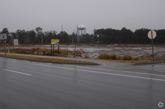
Commercialacreage
South Carolina
B and X Area of moderate flood hazard, usually the area between the limits of the 100-year and 500-year floods.
15.07 AC
2025
Greater Myrtle Beach
2025
Myrtle Beach/Conway
050600
NEARBY LISTINGS FOR SALE OR LEASE
DEMOGRAPHICS near Pine Island Rd
1 mile
3 mile
5 mile
2025 Total Population
3,950
43,402
106,225
2030 Population
4,454
49,450
120,694
Pop Growth 2025-2030
+ 12.76%
+ 13.93%
+ 13.62%
Average Age
40
42
43
2025 Total Households
1,521
18,411
44,898
HH Growth 2025-2030
+ 12.69%
+ 13.95%
+ 13.77%
Median Household Inc
$38,091
$53,142
$67,064
Avg Household Size
2.50
2.30
2.30
2025 Avg HH Vehicles
2.00
2.00
2.00
Median Home Value
$168,818
$337,090
$340,496
Median Year Built
1989
1998
2001
Nearby Places
Map Layers
Map Styles
 Street
 Aerial
Layers
 Traffic
 Biking
Places
Listings with unknown addresses are not visible on the map
- Restaurants
- Banks
- Shops
- Fitness
- Groceries
PUBLIC TRANSPORTATION
AIRPORT
Myrtle Beach International
Drive
Walk
Distance
Myrtle Beach International
9 min
3.2 mi
Freight Ports
Port of Wilmington
Drive
Walk
Distance
Port of Wilmington
97 min
74.7 mi
SALE & LEASE HISTORY
LISTING DATE
SALE/LEASE

Sep 25, 2016
For Lease
Sep 24, 2016
For Sale
Apr 10, 2017
For Lease
Nearby Properties
Address
Land Use
TOTAL SIZE
Lot Size
Zoning
Address
Land Use
TOTAL SIZE
Lot Size
Zoning
51,321 SF
1,047.85 AC
Address
Land Use
TOTAL SIZE
Lot Size
Zoning
1,410 SF
89.09 AC
Address
Land Use
TOTAL SIZE
Lot Size
Zoning
145,853 SF
57.75 AC
Address
Land Use
TOTAL SIZE
Lot Size
Zoning
165,655 SF
24.50 AC
Address
Land Use
TOTAL SIZE
Lot Size
Zoning
540,224 SF
1 AC
Address
Land Use
TOTAL SIZE
Lot Size
Zoning
146,900 SF
26.59 AC
Address
Land Use
TOTAL SIZE
Lot Size
Zoning
74,274 SF
17.09 AC
Address
Land Use
TOTAL SIZE
Lot Size
Zoning
23,964 SF
25.28 AC
Address
Land Use
TOTAL SIZE
Lot Size
Zoning
80,520 SF
4.02 AC
Address
Land Use
TOTAL SIZE
Lot Size
Zoning
128,560 SF
9.07 AC
Address
Land Use
TOTAL SIZE
Lot Size
Zoning
30,786 SF
18.30 AC
Address
Land Use
TOTAL SIZE
Lot Size
Zoning
48,393 SF
10.80 AC
Address
Land Use
TOTAL SIZE
Lot Size
Zoning
353,096 SF
0.51 AC
Address
Land Use
TOTAL SIZE
Lot Size
Zoning
243,600 SF
4.74 AC
Address
Land Use
TOTAL SIZE
Lot Size
Zoning
28,056 SF
29.16 AC
Address
Land Use
TOTAL SIZE
Lot Size
Zoning
107,068 SF
51.71 AC
Address
Land Use
TOTAL SIZE
Lot Size
Zoning
157,350 SF
1.07 AC
Address
Land Use
TOTAL SIZE
Lot Size
Zoning
214,125 SF
0.61 AC
Address
Land Use
TOTAL SIZE
Lot Size
Zoning
17,772 SF
17.30 AC
Address
Land Use
TOTAL SIZE
Lot Size
Zoning
68,660 SF
1.22 AC
Address
Land Use
TOTAL SIZE
Lot Size
Zoning
199,961 SF
0.56 AC
Address
Land Use
TOTAL SIZE
Lot Size
Zoning
87,068 SF
20.36 AC
Address
Land Use
TOTAL SIZE
Lot Size
Zoning
66,579 SF
3.92 AC
Address
Land Use
TOTAL SIZE
Lot Size
Zoning
203,336 SF
21.32 AC
Address
Land Use
TOTAL SIZE
Lot Size
Zoning
10,376 SF
18.40 AC
Address
Land Use
TOTAL SIZE
Lot Size
Zoning
26,048 SF
8.08 AC
Address
Land Use
TOTAL SIZE
Lot Size
Zoning
147.15 AC
The World's #1 Commercial Real Estate Marketplace
Connect with us
© 2026 CoStar Group
The information above has been obtained from sources believed reliable. While we do not doubt its accuracy we have not verified it and make no guarantee, warranty or representation about it. It is your responsibility to independently confirm its accuracy and completeness. Any projections, opinions, assumptions, or estimates used are for example only and do not represent the current or future performance of the property. The value of this transaction to you depends on tax and other factors which should be evaluated by your tax, financial, and legal advisors. You and your advisors should conduct a careful, independent investigation of the property to determine to your satisfaction the suitability of the property for your needs.