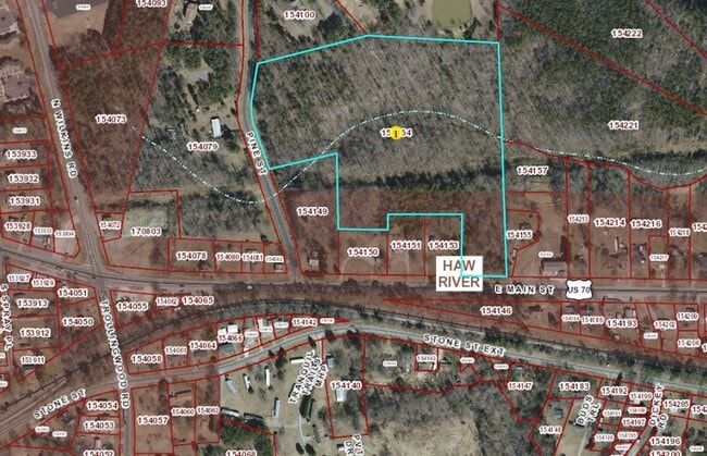
Property Record
Pine St, Mebane, NC 27302

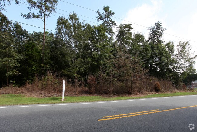
This Property Is For Sale
Property Detail
Pine St
Burlington, NC
PINE ST LT 4 13-11-49
154154
ALAMANCE
Miscellaneous
North Carolina
R 18
4
B and X Area of moderate flood hazard, usually the area between the limits of the 100-year and 500-year floods.
16.65 AC
0
N Central Alamance County
2025
Greensboro/Winston-Salem
021201
NEARBY LISTINGS FOR SALE OR LEASE
DEMOGRAPHICS near Pine St
1 mile
3 mile
5 mile
2024 Total Population
1,942
17,389
69,894
2029 Population
2,079
18,436
73,976
Pop Growth 2024-2029
+ 7.05%
+ 6.02%
+ 5.84%
Average Age
40
39
40
2024 Total Households
778
6,888
28,069
HH Growth 2024-2029
+ 7.20%
+ 6.23%
+ 6.02%
Median Household Inc
$66,657
$63,051
$58,722
Avg Household Size
2.50
2.50
2.40
2024 Avg HH Vehicles
2.00
2.00
2.00
Median Home Value
$154,601
$209,722
$241,181
Median Year Built
1984
1986
1984
Nearby Places
Map Layers
Map Styles
 Street
 Aerial
Transit
 Traffic
 Biking
Places
Listings with unknown addresses are not visible on the map
- Restaurants
- Banks
- Shops
- Fitness
- Groceries
PUBLIC TRANSPORTATION
COMMUTER RAIL
Burlington Station (Piedmont - North Carolina by Train (NC Train))
Drive
Walk
Distance
Burlington Station (Piedmont - North Carolina by Train (NC Train))
11 min
6.3 mi
Freight Ports
Virginia Port Authority - Richmond
Drive
Walk
Distance
Virginia Port Authority - Richmond
199 min
173.1 mi
Nearby Properties
Address
Land Use
TOTAL SIZE
Lot Size
Zoning
Address
Land Use
TOTAL SIZE
Lot Size
Zoning
18,778 SF
167.10 AC
R20
Address
Land Use
TOTAL SIZE
Lot Size
Zoning
919,840 SF
85.58 AC
Address
Land Use
TOTAL SIZE
Lot Size
Zoning
9,728 SF
184.66 AC
M 2
Address
Land Use
TOTAL SIZE
Lot Size
Zoning
159,629 SF
82.81 AC
Address
Land Use
TOTAL SIZE
Lot Size
Zoning
578,100 SF
55.30 AC
Address
Land Use
TOTAL SIZE
Lot Size
Zoning
48,136 SF
14.57 AC
B 2
Address
Land Use
TOTAL SIZE
Lot Size
Zoning
198,228 SF
25.26 AC
Address
Land Use
TOTAL SIZE
Lot Size
Zoning
367,187 SF
23.75 AC
M2
Address
Land Use
TOTAL SIZE
Lot Size
Zoning
476,857 SF
27.47 AC
M 2
Address
Land Use
TOTAL SIZE
Lot Size
Zoning
27,803 SF
11.53 AC
Address
Land Use
TOTAL SIZE
Lot Size
Zoning
33,280 SF
9.07 AC
I2
Address
Land Use
TOTAL SIZE
Lot Size
Zoning
296,940 SF
33.78 AC
Address
Land Use
TOTAL SIZE
Lot Size
Zoning
231,346 SF
37.07 AC
M 2
Address
Land Use
TOTAL SIZE
Lot Size
Zoning
3,534 SF
45.96 AC
Address
Land Use
TOTAL SIZE
Lot Size
Zoning
248,000 SF
21.77 AC
Address
Land Use
TOTAL SIZE
Lot Size
Zoning
180,000 SF
78.86 AC
M 2
Address
Land Use
TOTAL SIZE
Lot Size
Zoning
72,164 SF
73.50 AC
Address
Land Use
TOTAL SIZE
Lot Size
Zoning
316,832 SF
41.84 AC
M 1
Address
Land Use
TOTAL SIZE
Lot Size
Zoning
183,630 SF
10 AC
M2
Address
Land Use
TOTAL SIZE
Lot Size
Zoning
750 SF
65.26 AC
M 2
Address
Land Use
TOTAL SIZE
Lot Size
Zoning
51,994 SF
42.20 AC
OI
Address
Land Use
TOTAL SIZE
Lot Size
Zoning
134,000 SF
23.33 AC
Address
Land Use
TOTAL SIZE
Lot Size
Zoning
134,540 SF
16.31 AC
M 2
Address
Land Use
TOTAL SIZE
Lot Size
Zoning
156,000 SF
23.21 AC
Address
Land Use
TOTAL SIZE
Lot Size
Zoning
252,000 SF
20.94 AC
Address
Land Use
TOTAL SIZE
Lot Size
Zoning
134,230 SF
17.08 AC
M 2
Address
Land Use
TOTAL SIZE
Lot Size
Zoning
91,995 SF
25.44 AC
Address
Land Use
TOTAL SIZE
Lot Size
Zoning
134,230 SF
15.75 AC
M 2
Address
Land Use
TOTAL SIZE
Lot Size
Zoning
118,049 SF
16.92 AC
M 2
Address
Land Use
TOTAL SIZE
Lot Size
Zoning
58,312 SF
7.70 AC
B 2
The World's #1 Commercial Real Estate Marketplace
Connect with us
© 2026 CoStar Group
The information above has been obtained from sources believed reliable. While we do not doubt its accuracy we have not verified it and make no guarantee, warranty or representation about it. It is your responsibility to independently confirm its accuracy and completeness. Any projections, opinions, assumptions, or estimates used are for example only and do not represent the current or future performance of the property. The value of this transaction to you depends on tax and other factors which should be evaluated by your tax, financial, and legal advisors. You and your advisors should conduct a careful, independent investigation of the property to determine to your satisfaction the suitability of the property for your needs.