Property Record
Pitts School Rd Nw, Concord, NC 28027


NEARBY LISTINGS FOR SALE OR LEASE
Property Detail
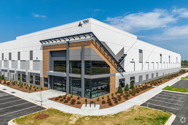
Pitts School Rd Nw
Charlotte-Concord-Gastonia, NC-SC
Airport
4599-38-6230-0000
PARCEL B BONDS FARM INDUSTRIAL PARK
Warehouse
Cabarrus
2025
North Carolina
2025
37.66 AC
042503
Cabarrus County
477,848 SF
Charlotte
DEMOGRAPHICS near Pitts School Rd Nw
1 Mile
3 Mile
5 Mile
2024 Total Population
2,718
39,609
130,439
2029 Population
3,075
44,131
143,625
Pop Growth 2024-2029
+ 13.13%
+ 11.42%
+ 10.11%
Average Age
38
37
37
2024 Total Households
1,073
15,083
49,270
HH Growth 2024-2029
+ 11.56%
+ 10.17%
+ 9.25%
Median Household Inc
$85,738
$95,446
$88,009
Avg Household Size
2.50
2.60
2.60
2024 Avg HH Vehicles
2.00
2.00
2.00
Median Home Value
$249,836
$329,532
$307,732
Median Year Built
2005
2004
2003
Nearby Places
Map Layers
Map Styles
 Street
 Aerial
- Restaurants
- Banks
- Shops
- Fitness
- Groceries
PUBLIC TRANSPORTATION
AIRPORT
Concord-Padgett Regional
DRIVE
WALK
Distance
Concord-Padgett Regional
9 min
3.8 mi
Charlotte/Douglas International
DRIVE
WALK
Distance
Charlotte/Douglas International
34 min
22.9 mi
Freight Ports
North Charleston Terminal
DRIVE
WALK
Distance
North Charleston Terminal
247 min
215.1 mi
SALE & LEASE HISTORY
LISTING DATE
SALE/LEASE

Mar 21, 2022
For Lease
Nearby Properties
Address
Land Use
TOTAL SIZE
Lot Size
Zoning
Address
Land Use
TOTAL SIZE
Lot Size
Zoning
701,530 SF
143.45 AC
C-2
Address
Land Use
TOTAL SIZE
Lot Size
Zoning
154,304 SF
857.72 AC
PID
Address
Land Use
TOTAL SIZE
Lot Size
Zoning
381,490 SF
29.24 AC
C-2
Address
Land Use
TOTAL SIZE
Lot Size
Zoning
374,697 SF
12.46 AC
Address
Land Use
TOTAL SIZE
Lot Size
Zoning
324,349 SF
4.69 AC
C-2
Address
Land Use
TOTAL SIZE
Lot Size
Zoning
14,742 SF
587.28 AC
I-1
Address
Land Use
TOTAL SIZE
Lot Size
Zoning
375,242 SF
25.64 AC
CC
Address
Land Use
TOTAL SIZE
Lot Size
Zoning
33,090 SF
19.43 AC
C-2
Address
Land Use
TOTAL SIZE
Lot Size
Zoning
23,940 SF
45.03 AC
C-1
Address
Land Use
TOTAL SIZE
Lot Size
Zoning
26,733 SF
48.78 AC
C-2
Address
Land Use
TOTAL SIZE
Lot Size
Zoning
29,658 SF
17.25 AC
MX-IB
Address
Land Use
TOTAL SIZE
Lot Size
Zoning
29,424 SF
22.77 AC
CD
Address
Land Use
TOTAL SIZE
Lot Size
Zoning
30,586 SF
54.10 AC
C-2
Address
Land Use
TOTAL SIZE
Lot Size
Zoning
57,268 SF
25.88 AC
C-2
Address
Land Use
TOTAL SIZE
Lot Size
Zoning
5,048 SF
26.66 AC
C-2
Address
Land Use
TOTAL SIZE
Lot Size
Zoning
300,275 SF
20.78 AC
MX2
Address
Land Use
TOTAL SIZE
Lot Size
Zoning
31,248 SF
21.72 AC
C-2
Address
Land Use
TOTAL SIZE
Lot Size
Zoning
670.09 AC
I-2
Address
Land Use
TOTAL SIZE
Lot Size
Zoning
260,820 SF
14.72 AC
R3
Address
Land Use
TOTAL SIZE
Lot Size
Zoning
276,620 SF
19.76 AC
R3
Address
Land Use
TOTAL SIZE
Lot Size
Zoning
43,005 SF
97.30 AC
RM-2
Address
Land Use
TOTAL SIZE
Lot Size
Zoning
330,544 SF
54.39 AC
CD
Address
Land Use
TOTAL SIZE
Lot Size
Zoning
62,780 SF
21.89 AC
Address
Land Use
TOTAL SIZE
Lot Size
Zoning
262,196 SF
21.30 AC
Address
Land Use
TOTAL SIZE
Lot Size
Zoning
289,262 SF
14.50 AC
CC
Address
Land Use
TOTAL SIZE
Lot Size
Zoning
22,198 SF
18.46 AC
C-2
Address
Land Use
TOTAL SIZE
Lot Size
Zoning
30,108 SF
42.53 AC
CD
Address
Land Use
TOTAL SIZE
Lot Size
Zoning
245,838 SF
6.13 AC
Address
Land Use
TOTAL SIZE
Lot Size
Zoning
350,339 SF
77.60 AC
RM-1
Address
Land Use
TOTAL SIZE
Lot Size
Zoning
249,618 SF
63.24 AC
RL
The World's #1 Commercial Real Estate Marketplace
Connect with us
© 2025 CoStar Group
The information above has been obtained from sources believed reliable. While we do not doubt its accuracy we have not verified it and make no guarantee, warranty or representation about it. It is your responsibility to independently confirm its accuracy and completeness. Any projections, opinions, assumptions, or estimates used are for example only and do not represent the current or future performance of the property. The value of this transaction to you depends on tax and other factors which should be evaluated by your tax, financial, and legal advisors. You and your advisors should conduct a careful, independent investigation of the property to determine to your satisfaction the suitability of the property for your needs.