No Photo
Property Record
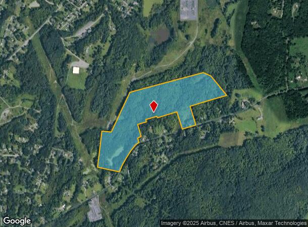
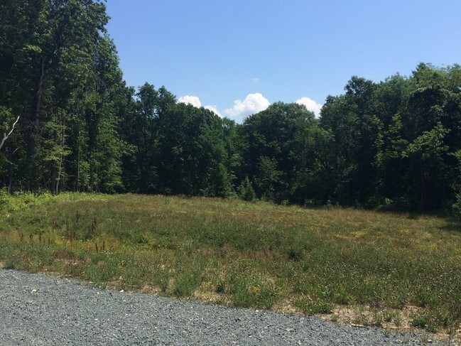
Plank Rd, Troy, NY 12182

NEARBY LISTINGS FOR SALE OR LEASE
-
-
View all Troy listings for sale on LoopNet.com
Property Detail
Plank Rd
Albany-Schenectady-Troy, NY
BACK REF 1750/141 PT IN SCHAGH 71.-2-60
2200-071-13-5.111
Rensselaer
Residentialacreage
New York
ARE
5.111
36083C0117D
67.97 AC
2025
Outer Rensselaer County
2024
Albany/Schenectady/Troy
041400
DEMOGRAPHICS near Plank Rd
1 Mile
3 Mile
5 Mile
2024 Total Population
1,371
18,677
67,585
2029 Population
1,349
18,349
66,801
Pop Growth 2024-2029
(1.60%)
(1.76%)
(1.16%)
Average Age
46
43
41
2024 Total Households
538
8,336
29,462
HH Growth 2024-2029
(1.86%)
(1.85%)
(1.30%)
Median Household Inc
$94,617
$61,429
$59,530
Avg Household Size
2.40
2.20
2.10
2024 Avg HH Vehicles
2.00
1.00
1.00
Median Home Value
$199,549
$182,580
$201,668
Median Year Built
1960
1954
1955
Nearby Places
- Restaurants
- Banks
- Shops
- Fitness
- Groceries
PUBLIC TRANSPORTATION
AIRPORT
Albany International
DRIVE
WALK
Distance
Albany International
21 min
12.3 mi
Freight Ports
Albany, NY Port
DRIVE
WALK
Distance
Albany, NY Port
26 min
15.0 mi
SALE & LEASE HISTORY
LISTING DATE
SALE/LEASE

Sep 24, 2016
For Sale
Dec 02, 2016
For Sale
Nearby Properties
Address
Land Use
TOTAL SIZE
Lot Size
Zoning
Address
Land Use
TOTAL SIZE
Lot Size
Zoning
173.09 AC
Address
Land Use
TOTAL SIZE
Lot Size
Zoning
5,000 SF
48.44 AC
CR
Address
Land Use
TOTAL SIZE
Lot Size
Zoning
39.06 AC
Address
Land Use
TOTAL SIZE
Lot Size
Zoning
77,193 SF
28.41 AC
SF
Address
Land Use
TOTAL SIZE
Lot Size
Zoning
Address
Land Use
TOTAL SIZE
Lot Size
Zoning
16,698 SF
46.45 AC
MF
Address
Land Use
TOTAL SIZE
Lot Size
Zoning
193,144 SF
41.18 AC
Address
Land Use
TOTAL SIZE
Lot Size
Zoning
346,727 SF
15.06 AC
03 - MULTI
Address
Land Use
TOTAL SIZE
Lot Size
Zoning
210,415 SF
1.69 AC
MF
Address
Land Use
TOTAL SIZE
Lot Size
Zoning
723,643 SF
27.56 AC
Address
Land Use
TOTAL SIZE
Lot Size
Zoning
5,500 SF
15.31 AC
MU2
Address
Land Use
TOTAL SIZE
Lot Size
Zoning
3,844 SF
3.18 AC
Address
Land Use
TOTAL SIZE
Lot Size
Zoning
Address
Land Use
TOTAL SIZE
Lot Size
Zoning
95,466 SF
7.64 AC
MF
Address
Land Use
TOTAL SIZE
Lot Size
Zoning
52 AC
CR
Address
Land Use
TOTAL SIZE
Lot Size
Zoning
86,904 SF
150.22 AC
Address
Land Use
TOTAL SIZE
Lot Size
Zoning
2,560 SF
9.30 AC
A3
Address
Land Use
TOTAL SIZE
Lot Size
Zoning
75,872 SF
8.26 AC
SF
Address
Land Use
TOTAL SIZE
Lot Size
Zoning
15,562 SF
1.91 AC
WMU
Address
Land Use
TOTAL SIZE
Lot Size
Zoning
88.48 AC
Address
Land Use
TOTAL SIZE
Lot Size
Zoning
51,926 SF
2.02 AC
MF
Address
Land Use
TOTAL SIZE
Lot Size
Zoning
30,600 SF
258.51 AC
Address
Land Use
TOTAL SIZE
Lot Size
Zoning
16,768 SF
9.10 AC
MF
Address
Land Use
TOTAL SIZE
Lot Size
Zoning
10,980 SF
1.53 AC
MU2
Address
Land Use
TOTAL SIZE
Lot Size
Zoning
30,390 SF
1.20 AC
03 - MULTI
Address
Land Use
TOTAL SIZE
Lot Size
Zoning
114,539 SF
11.64 AC
Address
Land Use
TOTAL SIZE
Lot Size
Zoning
23,700 SF
5.01 AC
SF
Address
Land Use
TOTAL SIZE
Lot Size
Zoning
44,500 SF
6.71 AC
WMU
Address
Land Use
TOTAL SIZE
Lot Size
Zoning
49.19 AC
Address
Land Use
TOTAL SIZE
Lot Size
Zoning
60,794 SF
7.87 AC
The World's #1 Commercial Real Estate Marketplace
Connect with us
© 2025 CoStar Group
The information above has been obtained from sources believed reliable. While we do not doubt its accuracy we have not verified it and make no guarantee, warranty or representation about it. It is your responsibility to independently confirm its accuracy and completeness. Any projections, opinions, assumptions, or estimates used are for example only and do not represent the current or future performance of the property. The value of this transaction to you depends on tax and other factors which should be evaluated by your tax, financial, and legal advisors. You and your advisors should conduct a careful, independent investigation of the property to determine to your satisfaction the suitability of the property for your needs.