Property Record
Poplin Rd, Indian Trail, NC 28079
Save to a Folder
{{folder.Name}}
{{folder.ListingIds.length}} Properties
{{folder.ListingIds.length}} Property
Create a New Folder
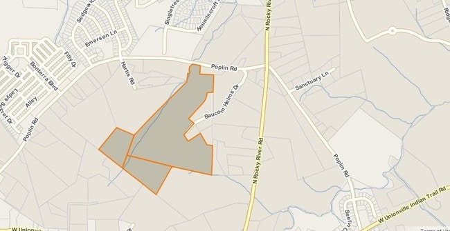
Property Detail
Poplin Rd
Charlotte-Concord-Gastonia, NC-SC
TRACT 1 OPCM614-616
07-021-007-D
UNION
Agriculturalland
North Carolina
PUD INDIAN
07
AE The base floodplain where base flood elevations are provided. AE Zones are now used on new format FIRMs instead of A1-A30 Zones.
56.73 AC
2025
Union County
2025
Charlotte
021004
NEARBY LISTINGS FOR SALE OR LEASE
DEMOGRAPHICS near Poplin Rd
1 mile
3 mile
5 mile
2025 Total Population
4,503
28,808
69,131
2030 Population
4,981
31,470
75,554
Pop Growth 2025-2030
+ 10.62%
+ 9.24%
+ 9.29%
Average Age
36
38
39
2025 Total Households
1,388
9,809
24,212
HH Growth 2025-2030
+ 10.73%
+ 9.26%
+ 9.41%
Median Household Inc
$104,194
$92,803
$93,991
Avg Household Size
3.20
2.90
2.80
2025 Avg HH Vehicles
2.00
2.00
2.00
Median Home Value
$408,149
$376,356
$391,225
Median Year Built
2010
2002
2000
Nearby Places
Map Layers
Map Styles
 Street
 Aerial
Layers
 Traffic
 Biking
Places
Listings with unknown addresses are not visible on the map
- Restaurants
- Banks
- Shops
- Fitness
- Groceries
PUBLIC TRANSPORTATION
AIRPORT
Charlotte/Douglas International
Drive
Walk
Distance
Charlotte/Douglas International
44 min
27.0 mi
Concord-Padgett Regional
Drive
Walk
Distance
Concord-Padgett Regional
40 min
28.0 mi
Freight Ports
North Charleston Terminal
Drive
Walk
Distance
North Charleston Terminal
237 min
193.6 mi
Nearby Properties
Address
Land Use
TOTAL SIZE
Lot Size
Zoning
Address
Land Use
TOTAL SIZE
Lot Size
Zoning
170,725 SF
179.83 AC
RA-40 UNIO
Address
Land Use
TOTAL SIZE
Lot Size
Zoning
27,900 SF
15.59 AC
MFR INDIAN
Address
Land Use
TOTAL SIZE
Lot Size
Zoning
23.16 AC
CD MONROE
Address
Land Use
TOTAL SIZE
Lot Size
Zoning
103,100 SF
28.55 AC
RBD INDIAN
Address
Land Use
TOTAL SIZE
Lot Size
Zoning
86,960 SF
14.13 AC
SF-1 INDIA
Address
Land Use
TOTAL SIZE
Lot Size
Zoning
97,318 SF
27.57 AC
RA-40 UNIO
Address
Land Use
TOTAL SIZE
Lot Size
Zoning
45,053 SF
15.03 AC
RBD INDIAN
Address
Land Use
TOTAL SIZE
Lot Size
Zoning
15.33 AC
Address
Land Use
TOTAL SIZE
Lot Size
Zoning
139,853 SF
16.30 AC
RBD INDIAN
Address
Land Use
TOTAL SIZE
Lot Size
Zoning
40,680 SF
15.13 AC
Address
Land Use
TOTAL SIZE
Lot Size
Zoning
30.42 AC
HC UNION C
Address
Land Use
TOTAL SIZE
Lot Size
Zoning
74,932 SF
20.65 AC
R-20 UNION
Address
Land Use
TOTAL SIZE
Lot Size
Zoning
25.10 AC
RBD INDIAN
Address
Land Use
TOTAL SIZE
Lot Size
Zoning
29,300 SF
5.51 AC
RBD INDIAN
Address
Land Use
TOTAL SIZE
Lot Size
Zoning
24.50 AC
HC UNION C
Address
Land Use
TOTAL SIZE
Lot Size
Zoning
50,111 SF
4.62 AC
GB LAKE PA
Address
Land Use
TOTAL SIZE
Lot Size
Zoning
12,724 SF
12.51 AC
RBD INDIAN
Address
Land Use
TOTAL SIZE
Lot Size
Zoning
19,544 SF
11 AC
RBD INDIAN
Address
Land Use
TOTAL SIZE
Lot Size
Zoning
36,731 SF
7.01 AC
GBD INDIAN
Address
Land Use
TOTAL SIZE
Lot Size
Zoning
19,214 SF
6 AC
HC UNION C
Address
Land Use
TOTAL SIZE
Lot Size
Zoning
36,090 SF
4.68 AC
R-40 MONRO
Address
Land Use
TOTAL SIZE
Lot Size
Zoning
77,217 SF
3.88 AC
RBD INDIAN
Address
Land Use
TOTAL SIZE
Lot Size
Zoning
21,934 SF
16.22 AC
RA-40 UNIO
Address
Land Use
TOTAL SIZE
Lot Size
Zoning
43,843 SF
30 AC
SF-1 INDIA
Address
Land Use
TOTAL SIZE
Lot Size
Zoning
25.49 AC
HC UNION C
Address
Land Use
TOTAL SIZE
Lot Size
Zoning
5.14 AC
LI INDIAN
Address
Land Use
TOTAL SIZE
Lot Size
Zoning
Address
Land Use
TOTAL SIZE
Lot Size
Zoning
13.65 AC
RBD INDIAN
Address
Land Use
TOTAL SIZE
Lot Size
Zoning
24,400 SF
3.30 AC
GB MONROE
Address
Land Use
TOTAL SIZE
Lot Size
Zoning
15,718 SF
11.81 AC
CS LAKE PA
The World's #1 Commercial Real Estate Marketplace
Connect with us
© 2026 CoStar Group
The information above has been obtained from sources believed reliable. While we do not doubt its accuracy we have not verified it and make no guarantee, warranty or representation about it. It is your responsibility to independently confirm its accuracy and completeness. Any projections, opinions, assumptions, or estimates used are for example only and do not represent the current or future performance of the property. The value of this transaction to you depends on tax and other factors which should be evaluated by your tax, financial, and legal advisors. You and your advisors should conduct a careful, independent investigation of the property to determine to your satisfaction the suitability of the property for your needs.