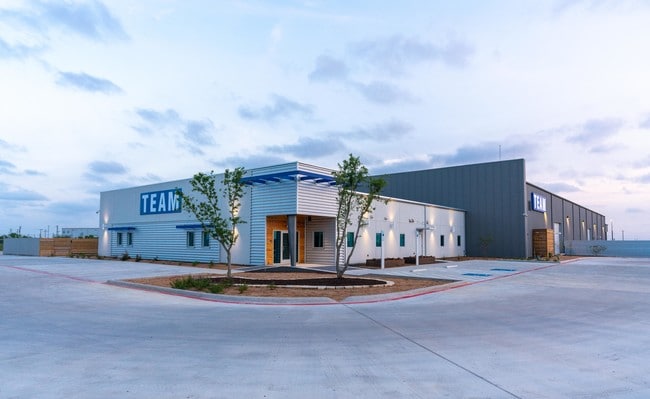
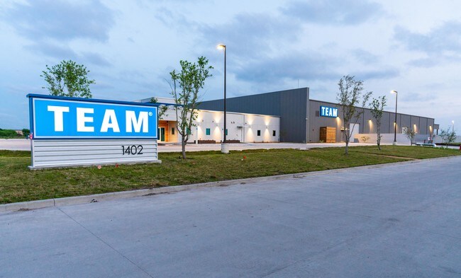
Property Record
1402 Spindletop Rd, Corpus Christi, TX 78409


NEARBY LISTINGS FOR SALE OR LEASE
Property Detail
1402 Spindletop Rd
Corpus Christi, TX
Wildcat Industrial Park
524980
WILDCAT INDUSTRIAL PARK BLK 1 LOT 9
Commercialnec
Nueces
X
Texas
48355C0300G
9
2024
5.01 AC
2025
Northwest
003500
Corpus Christi
38,279 SF
DEMOGRAPHICS near 1402 Spindletop Rd
1 Mile
3 Mile
5 Mile
2024 Total Population
298
7,973
29,080
2029 Population
308
7,979
28,849
Pop Growth 2024-2029
+ 3.36%
+ 0.08%
(0.79%)
Average Age
38
38
37
2024 Total Households
104
2,909
10,176
HH Growth 2024-2029
+ 3.85%
(0.14%)
(0.95%)
Median Household Inc
$44,499
$45,602
$46,073
Avg Household Size
2.90
2.60
2.80
2024 Avg HH Vehicles
2.00
2.00
2.00
Median Home Value
$84,210
$96,813
$99,719
Median Year Built
1979
1983
1977
Nearby Places
- Restaurants
- Banks
- Shops
- Fitness
- Groceries
PUBLIC TRANSPORTATION
AIRPORT
Corpus Christi International
DRIVE
WALK
Distance
Corpus Christi International
12 min
6.4 mi
Freight Ports
Port of Corpus Christi
DRIVE
WALK
Distance
Port of Corpus Christi
11 min
7.6 mi
SALE & LEASE HISTORY
LISTING DATE
SALE/LEASE

Nov 30, 2020
For Sale
May 30, 2019
For Sale
Nearby Properties
Address
Land Use
TOTAL SIZE
Lot Size
Zoning
Address
Land Use
TOTAL SIZE
Lot Size
Zoning
174,650 SF
1.95 AC
I3
Address
Land Use
TOTAL SIZE
Lot Size
Zoning
Address
Land Use
TOTAL SIZE
Lot Size
Zoning
233,436 SF
Address
Land Use
TOTAL SIZE
Lot Size
Zoning
126,708 SF
18.17 AC
R1B
Address
Land Use
TOTAL SIZE
Lot Size
Zoning
368.71 AC
OCL
Address
Land Use
TOTAL SIZE
Lot Size
Zoning
105,979 SF
25 AC
I2SP92
Address
Land Use
TOTAL SIZE
Lot Size
Zoning
67,009 SF
6.99 AC
R1B
Address
Land Use
TOTAL SIZE
Lot Size
Zoning
600.26 AC
Address
Land Use
TOTAL SIZE
Lot Size
Zoning
Address
Land Use
TOTAL SIZE
Lot Size
Zoning
72.29 AC
OCL
Address
Land Use
TOTAL SIZE
Lot Size
Zoning
234.07 AC
OCL
Address
Land Use
TOTAL SIZE
Lot Size
Zoning
141,800 SF
6 AC
Address
Land Use
TOTAL SIZE
Lot Size
Zoning
148,070 SF
17 AC
Address
Land Use
TOTAL SIZE
Lot Size
Zoning
139.72 AC
OCL
Address
Land Use
TOTAL SIZE
Lot Size
Zoning
50.32 AC
OCL
Address
Land Use
TOTAL SIZE
Lot Size
Zoning
Address
Land Use
TOTAL SIZE
Lot Size
Zoning
71,839 SF
30.18 AC
Address
Land Use
TOTAL SIZE
Lot Size
Zoning
26,200 SF
4.86 AC
I-2
Address
Land Use
TOTAL SIZE
Lot Size
Zoning
151,918 SF
10 AC
I-3
Address
Land Use
TOTAL SIZE
Lot Size
Zoning
108,360 SF
8.12 AC
B4
Address
Land Use
TOTAL SIZE
Lot Size
Zoning
57,512 SF
9.65 AC
Address
Land Use
TOTAL SIZE
Lot Size
Zoning
119.40 AC
OCL
Address
Land Use
TOTAL SIZE
Lot Size
Zoning
20,744 SF
23.64 AC
Address
Land Use
TOTAL SIZE
Lot Size
Zoning
56,431 SF
21.27 AC
Address
Land Use
TOTAL SIZE
Lot Size
Zoning
50,348 SF
11.17 AC
Address
Land Use
TOTAL SIZE
Lot Size
Zoning
96.23 AC
OCL
Address
Land Use
TOTAL SIZE
Lot Size
Zoning
167.06 AC
Address
Land Use
TOTAL SIZE
Lot Size
Zoning
66,052 SF
23.95 AC
I2SP08
Address
Land Use
TOTAL SIZE
Lot Size
Zoning
7,400 SF
43.16 AC
OCL
Address
Land Use
TOTAL SIZE
Lot Size
Zoning
52,096 SF
1.88 AC
B-4
The World's #1 Commercial Real Estate Marketplace
Connect with us
© 2025 CoStar Group
The information above has been obtained from sources believed reliable. While we do not doubt its accuracy we have not verified it and make no guarantee, warranty or representation about it. It is your responsibility to independently confirm its accuracy and completeness. Any projections, opinions, assumptions, or estimates used are for example only and do not represent the current or future performance of the property. The value of this transaction to you depends on tax and other factors which should be evaluated by your tax, financial, and legal advisors. You and your advisors should conduct a careful, independent investigation of the property to determine to your satisfaction the suitability of the property for your needs.