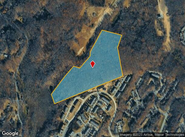
Property Record
Post Rd Rear Rd, Hardyston, NJ 07419
NEARBY LISTINGS FOR SALE OR LEASE
Property Detail
Post Rd Rear Rd
11-00067-0000-00019-0000-QFARM
Sussex
Farms
New Jersey
X
19
34037C0190E
14 AC
2024
Sussex County
2025
Northern New Jersey
372700
Newark, NJ-PA
DEMOGRAPHICS near Post Rd Rear Rd
1 Mile
3 Mile
5 Mile
2024 Total Population
2,789
13,928
29,742
2029 Population
2,846
14,133
30,137
Pop Growth 2024-2029
+ 2.04%
+ 1.47%
+ 1.33%
Average Age
42
44
44
2024 Total Households
1,172
5,857
11,973
HH Growth 2024-2029
+ 2.22%
+ 1.59%
+ 1.40%
Median Household Inc
$74,014
$84,753
$90,248
Avg Household Size
2.40
2.40
2.50
2024 Avg HH Vehicles
2.00
2.00
2.00
Median Home Value
$247,290
$260,714
$280,023
Median Year Built
1992
1980
1976
Nearby Places
Map Layers
Map Styles
 Street
 Aerial
- Restaurants
- Banks
- Shops
- Fitness
- Groceries
SALE & LEASE HISTORY
LISTING DATE
SALE/LEASE

Mar 28, 2017
For Sale
Nearby Properties
Address
Land Use
TOTAL SIZE
Lot Size
Zoning
Address
Land Use
TOTAL SIZE
Lot Size
Zoning
68.74 AC
R-C
Address
Land Use
TOTAL SIZE
Lot Size
Zoning
66.06 AC
GC
Address
Land Use
TOTAL SIZE
Lot Size
Zoning
10.83 AC
OSGU
Address
Land Use
TOTAL SIZE
Lot Size
Zoning
18.69 AC
R-4
Address
Land Use
TOTAL SIZE
Lot Size
Zoning
83.51 AC
TCSC
Address
Land Use
TOTAL SIZE
Lot Size
Zoning
Address
Land Use
TOTAL SIZE
Lot Size
Zoning
12.80 AC
R-4
Address
Land Use
TOTAL SIZE
Lot Size
Zoning
16.88 AC
HC-1
Address
Land Use
TOTAL SIZE
Lot Size
Zoning
10.02 AC
HC-1
Address
Land Use
TOTAL SIZE
Lot Size
Zoning
230.56 AC
B-1
Address
Land Use
TOTAL SIZE
Lot Size
Zoning
0.90 AC
Address
Land Use
TOTAL SIZE
Lot Size
Zoning
10 AC
P
Address
Land Use
TOTAL SIZE
Lot Size
Zoning
38.17 AC
HC-1
Address
Land Use
TOTAL SIZE
Lot Size
Zoning
3,048 SF
51 AC
I-2
Address
Land Use
TOTAL SIZE
Lot Size
Zoning
836 SF
10 AC
I-1
Address
Land Use
TOTAL SIZE
Lot Size
Zoning
Address
Land Use
TOTAL SIZE
Lot Size
Zoning
Address
Land Use
TOTAL SIZE
Lot Size
Zoning
10.29 AC
MID3
Address
Land Use
TOTAL SIZE
Lot Size
Zoning
2.20 AC
BAR
Address
Land Use
TOTAL SIZE
Lot Size
Zoning
960 SF
3.38 AC
B-1
Address
Land Use
TOTAL SIZE
Lot Size
Zoning
9.02 AC
B-1
Address
Land Use
TOTAL SIZE
Lot Size
Zoning
Address
Land Use
TOTAL SIZE
Lot Size
Zoning
6 AC
GC
Address
Land Use
TOTAL SIZE
Lot Size
Zoning
1,920 SF
1.59 AC
HC-1
Address
Land Use
TOTAL SIZE
Lot Size
Zoning
1,860 SF
51.68 AC
I-1
Address
Land Use
TOTAL SIZE
Lot Size
Zoning
Address
Land Use
TOTAL SIZE
Lot Size
Zoning
3.95 AC
I-2
Address
Land Use
TOTAL SIZE
Lot Size
Zoning
11.60 AC
HWCO
Address
Land Use
TOTAL SIZE
Lot Size
Zoning
5.19 AC
I-2
Address
Land Use
TOTAL SIZE
Lot Size
Zoning
4.58 AC
R20
The World's #1 Commercial Real Estate Marketplace
Connect with us
© 2025 CoStar Group
The information above has been obtained from sources believed reliable. While we do not doubt its accuracy we have not verified it and make no guarantee, warranty or representation about it. It is your responsibility to independently confirm its accuracy and completeness. Any projections, opinions, assumptions, or estimates used are for example only and do not represent the current or future performance of the property. The value of this transaction to you depends on tax and other factors which should be evaluated by your tax, financial, and legal advisors. You and your advisors should conduct a careful, independent investigation of the property to determine to your satisfaction the suitability of the property for your needs.