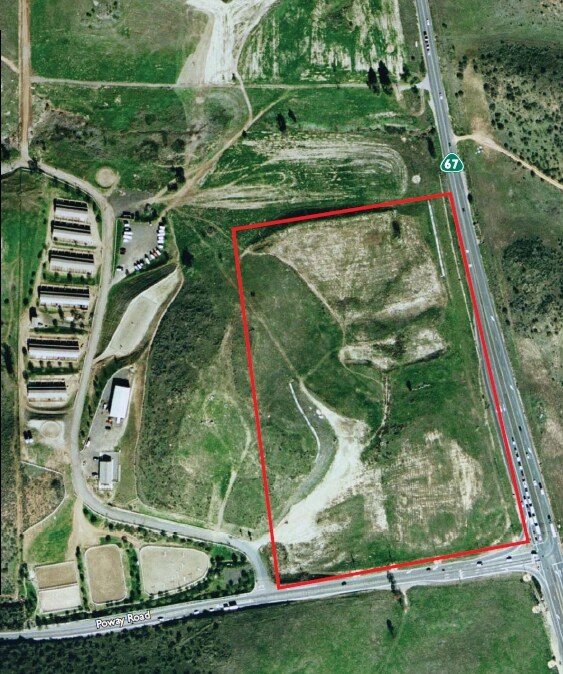
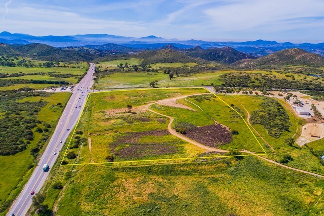
Property Record
Highway 67, Poway, CA 92065


Property Detail
Highway 67
322-011-09
PAR 4 TR PM18327
Residentialacreage
SAN DIEGO
RR-A
California
B and X Area of moderate flood hazard, usually the area between the limits of the 100-year and 500-year floods.
20.02 AC
2024
Poway
2025
San Diego
020813
San Diego-Chula Vista-Carlsbad, CA
NEARBY LISTINGS FOR SALE OR LEASE
-
-
View all Poway listings for sale on LoopNet.com
DEMOGRAPHICS near Highway 67
1 mile
3 mile
5 mile
2024 Total Population
101
6,896
42,813
2029 Population
100
6,857
42,705
Pop Growth 2024-2029
(0.99%)
(0.57%)
(0.25%)
Average Age
44
43
42
2024 Total Households
36
2,265
14,166
HH Growth 2024-2029
0.00%
(0.79%)
(0.40%)
Median Household Inc
$189,999
$191,142
$159,413
Avg Household Size
2.70
3.00
2.90
2024 Avg HH Vehicles
3.00
3.00
2.00
Median Home Value
$1,055,263
$1,065,544
$1,029,459
Median Year Built
1990
1982
1979
Nearby Places
Map Layers
Map Styles
 Street
 Aerial
Transit
 Traffic
 Biking
Places
Listings with unknown addresses are not visible on the map
- Restaurants
- Banks
- Shops
- Fitness
- Groceries
PUBLIC TRANSPORTATION
AIRPORT
San Diego International
Drive
Walk
Distance
San Diego International
38 min
27.2 mi
Freight Ports
Port of San Diego
Drive
Walk
Distance
Port of San Diego
40 min
29.4 mi
SALE & LEASE HISTORY
LISTING DATE
SALE/LEASE

Aug 02, 2017
For Sale
Nearby Properties
Address
Land Use
TOTAL SIZE
Lot Size
Zoning
Address
Land Use
TOTAL SIZE
Lot Size
Zoning
14,380 SF
0.85 AC
CN
Address
Land Use
TOTAL SIZE
Lot Size
Zoning
5,949 SF
30.36 AC
RR-A
Address
Land Use
TOTAL SIZE
Lot Size
Zoning
73.78 AC
A70
Address
Land Use
TOTAL SIZE
Lot Size
Zoning
61.26 AC
A70
Address
Land Use
TOTAL SIZE
Lot Size
Zoning
3.21 AC
RR-C
Address
Land Use
TOTAL SIZE
Lot Size
Zoning
7,820 SF
6.71 AC
A70
Address
Land Use
TOTAL SIZE
Lot Size
Zoning
6,574 SF
1.16 AC
RR-C
Address
Land Use
TOTAL SIZE
Lot Size
Zoning
1,078 SF
109.86 AC
RR-A
Address
Land Use
TOTAL SIZE
Lot Size
Zoning
2,400 SF
0.32 AC
CN
Address
Land Use
TOTAL SIZE
Lot Size
Zoning
9,427 SF
12.14 AC
C42
Address
Land Use
TOTAL SIZE
Lot Size
Zoning
2.68 AC
RS-4
Address
Land Use
TOTAL SIZE
Lot Size
Zoning
3.89 AC
RR-B
Address
Land Use
TOTAL SIZE
Lot Size
Zoning
182.70 AC
RR-A
Address
Land Use
TOTAL SIZE
Lot Size
Zoning
14.48 AC
RR-A
Address
Land Use
TOTAL SIZE
Lot Size
Zoning
5,165 SF
64.76 AC
RR-A
Address
Land Use
TOTAL SIZE
Lot Size
Zoning
80 AC
RR-B
Address
Land Use
TOTAL SIZE
Lot Size
Zoning
81.04 AC
RR-A
Address
Land Use
TOTAL SIZE
Lot Size
Zoning
81.04 AC
RR-A
Address
Land Use
TOTAL SIZE
Lot Size
Zoning
4,500 SF
4.85 AC
RR-C
Address
Land Use
TOTAL SIZE
Lot Size
Zoning
354.75 AC
A70
Address
Land Use
TOTAL SIZE
Lot Size
Zoning
135.77 AC
RR-A
Address
Land Use
TOTAL SIZE
Lot Size
Zoning
3,804 SF
82.21 AC
A70
Address
Land Use
TOTAL SIZE
Lot Size
Zoning
4,471 SF
5.63 AC
A70
Address
Land Use
TOTAL SIZE
Lot Size
Zoning
5,770 SF
12.14 AC
A70
Address
Land Use
TOTAL SIZE
Lot Size
Zoning
4,443 SF
2.76 AC
RR-C
Address
Land Use
TOTAL SIZE
Lot Size
Zoning
2,068 SF
2.15 AC
RR-B
Address
Land Use
TOTAL SIZE
Lot Size
Zoning
227.99 AC
RR-A
Address
Land Use
TOTAL SIZE
Lot Size
Zoning
2,458 SF
4.34 AC
A70
Address
Land Use
TOTAL SIZE
Lot Size
Zoning
3,228 SF
4.02 AC
RR-B
The World's #1 Commercial Real Estate Marketplace
Connect with us
© 2026 CoStar Group
The information above has been obtained from sources believed reliable. While we do not doubt its accuracy we have not verified it and make no guarantee, warranty or representation about it. It is your responsibility to independently confirm its accuracy and completeness. Any projections, opinions, assumptions, or estimates used are for example only and do not represent the current or future performance of the property. The value of this transaction to you depends on tax and other factors which should be evaluated by your tax, financial, and legal advisors. You and your advisors should conduct a careful, independent investigation of the property to determine to your satisfaction the suitability of the property for your needs.