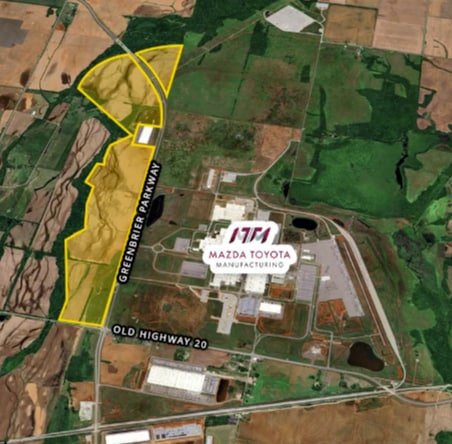
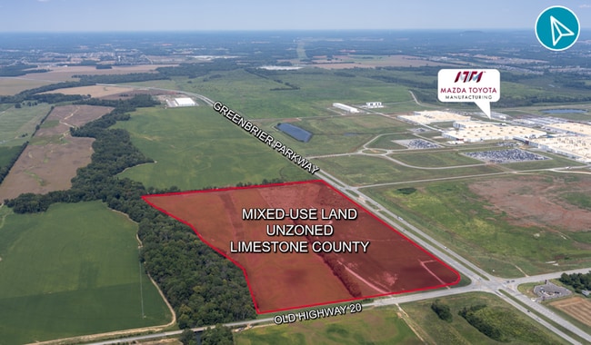
Property Record
Powell Rd, Madison, AL 35756
This Property Is For Sale
Property Detail
Powell Rd
Huntsville, AL
BEG NE COR SEC 21 W 60 S 196 E 1256.98 S2469 W 1288 N 1439 POB ANNEXED INTO CITY OF HUNTSVILLE ORD # 08-269( LESS 11 AC GREE
17-03-08-0-000-004.000
LIMESTONE
Agriculturalland
Alabama
AE The base floodplain where base flood elevations are provided. AE Zones are now used on new format FIRMs instead of A1-A30 Zones.
101.09 AC
2025
Outlying Limestone County
2025
Huntsville
021203
NEARBY LISTINGS FOR SALE OR LEASE
DEMOGRAPHICS near Powell Rd
1 mile
3 mile
5 mile
2025 Total Population
10
2,728
22,898
2030 Population
12
3,104
25,706
Pop Growth 2025-2030
+ 20.00%
+ 13.78%
+ 12.26%
Average Age
32
36
37
2025 Total Households
4
929
7,957
HH Growth 2025-2030
0.00%
+ 13.99%
+ 12.52%
Median Household Inc
$175,000
$159,537
$148,206
Avg Household Size
2.50
2.90
2.90
2025 Avg HH Vehicles
3.00
2.00
2.00
Median Home Value
$750,000
$488,513
$446,585
Median Year Built
2011
2010
2010
Nearby Places
Map Layers
Map Styles
 Street
 Aerial
Layers
 Traffic
 Biking
Places
Listings with unknown addresses are not visible on the map
- Restaurants
- Banks
- Shops
- Fitness
- Groceries
PUBLIC TRANSPORTATION
AIRPORT
Huntsville International-Carl T Jones Field
Drive
Walk
Distance
Huntsville International-Carl T Jones Field
20 min
12.0 mi
Freight Ports
Port of Mobile
Drive
Walk
Distance
Port of Mobile
378 min
344.1 mi
Nearby Properties
Address
Land Use
TOTAL SIZE
Lot Size
Zoning
Address
Land Use
TOTAL SIZE
Lot Size
Zoning
1,419,242 SF
508 AC
Address
Land Use
TOTAL SIZE
Lot Size
Zoning
2,125 SF
Address
Land Use
TOTAL SIZE
Lot Size
Zoning
404,642 SF
Address
Land Use
TOTAL SIZE
Lot Size
Zoning
1,084,811 SF
94.45 AC
Address
Land Use
TOTAL SIZE
Lot Size
Zoning
217,800 SF
Address
Land Use
TOTAL SIZE
Lot Size
Zoning
113,450 SF
Address
Land Use
TOTAL SIZE
Lot Size
Zoning
8,096 SF
7.15 AC
Address
Land Use
TOTAL SIZE
Lot Size
Zoning
290,160 SF
17.37 AC
Address
Land Use
TOTAL SIZE
Lot Size
Zoning
39,000 SF
Address
Land Use
TOTAL SIZE
Lot Size
Zoning
588.12 AC
Address
Land Use
TOTAL SIZE
Lot Size
Zoning
Address
Land Use
TOTAL SIZE
Lot Size
Zoning
60,000 SF
Address
Land Use
TOTAL SIZE
Lot Size
Zoning
37,759 SF
2.76 AC
Address
Land Use
TOTAL SIZE
Lot Size
Zoning
980 SF
290.40 AC
Address
Land Use
TOTAL SIZE
Lot Size
Zoning
25,000 SF
Address
Land Use
TOTAL SIZE
Lot Size
Zoning
120 AC
Address
Land Use
TOTAL SIZE
Lot Size
Zoning
22,400 SF
1.13 AC
Address
Land Use
TOTAL SIZE
Lot Size
Zoning
23,924 SF
Address
Land Use
TOTAL SIZE
Lot Size
Zoning
19,800 SF
6 AC
Address
Land Use
TOTAL SIZE
Lot Size
Zoning
417.90 AC
Address
Land Use
TOTAL SIZE
Lot Size
Zoning
23,000 SF
3 AC
Address
Land Use
TOTAL SIZE
Lot Size
Zoning
2,800 SF
1.35 AC
Address
Land Use
TOTAL SIZE
Lot Size
Zoning
13,632 SF
24.87 AC
Address
Land Use
TOTAL SIZE
Lot Size
Zoning
Address
Land Use
TOTAL SIZE
Lot Size
Zoning
7,440 SF
0.48 AC
Address
Land Use
TOTAL SIZE
Lot Size
Zoning
7,200 SF
0.58 AC
Address
Land Use
TOTAL SIZE
Lot Size
Zoning
29 AC
Address
Land Use
TOTAL SIZE
Lot Size
Zoning
5,940 SF
0.49 AC
The World's #1 Commercial Real Estate Marketplace
Connect with us
© 2026 CoStar Group
The information above has been obtained from sources believed reliable. While we do not doubt its accuracy we have not verified it and make no guarantee, warranty or representation about it. It is your responsibility to independently confirm its accuracy and completeness. Any projections, opinions, assumptions, or estimates used are for example only and do not represent the current or future performance of the property. The value of this transaction to you depends on tax and other factors which should be evaluated by your tax, financial, and legal advisors. You and your advisors should conduct a careful, independent investigation of the property to determine to your satisfaction the suitability of the property for your needs.