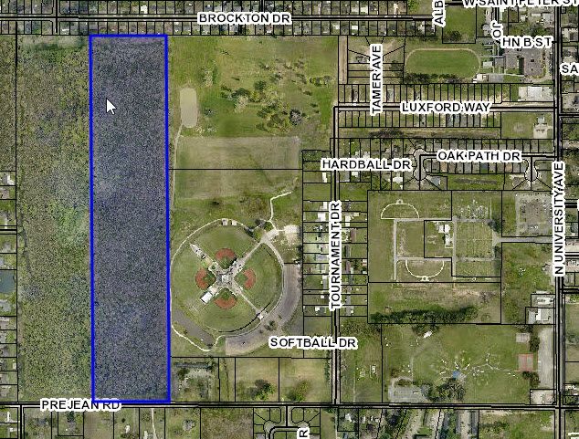
Property Record
400 Blk Prejean Rd, Carencro, LA 70520

This Property Is For Sale
Property Detail
400 Blk Prejean Rd
Lafayette, LA
SEC 33 T8S R4E (34.889 AC)
6020480
LAFAYETTE
Institutionalvacantland
Louisiana
B and X Area of moderate flood hazard, usually the area between the limits of the 100-year and 500-year floods.
34.89 AC
2024
Outlying Lafayette Parish
2024
Lafayette
002102
NEARBY LISTINGS FOR SALE OR LEASE
-
-
View all Carencro listings for sale on LoopNet.com
DEMOGRAPHICS near 400 Blk Prejean Rd
1 mile
3 mile
5 mile
2025 Total Population
4,522
25,667
54,547
2030 Population
4,728
26,909
56,998
Pop Growth 2025-2030
+ 4.56%
+ 4.84%
+ 4.49%
Average Age
37
37
38
2025 Total Households
1,671
9,761
20,916
HH Growth 2025-2030
+ 4.61%
+ 4.92%
+ 4.56%
Median Household Inc
$64,692
$64,121
$59,511
Avg Household Size
2.60
2.50
2.50
2025 Avg HH Vehicles
2.00
2.00
2.00
Median Home Value
$207,509
$220,593
$203,813
Median Year Built
1988
1998
1988
Nearby Places
Map Layers
Map Styles
 Street
 Aerial
Transit
 Traffic
 Biking
Places
Listings with unknown addresses are not visible on the map
- Restaurants
- Banks
- Shops
- Fitness
- Groceries
PUBLIC TRANSPORTATION
COMMUTER RAIL
Lafayette Amtrak Station (Sunset Limited - Amtrak)
Drive
Walk
Distance
Lafayette Amtrak Station (Sunset Limited - Amtrak)
15 min
8.5 mi
AIRPORT
Lafayette Regional/Paul Fournet Field
Drive
Walk
Distance
Lafayette Regional/Paul Fournet Field
19 min
10.6 mi
Freight Ports
Port of Iberia
Drive
Walk
Distance
Port of Iberia
45 min
31.5 mi
Nearby Properties
Address
Land Use
TOTAL SIZE
Lot Size
Zoning
Address
Land Use
TOTAL SIZE
Lot Size
Zoning
Address
Land Use
TOTAL SIZE
Lot Size
Zoning
181,875 SF
50.80 AC
Address
Land Use
TOTAL SIZE
Lot Size
Zoning
236,530 SF
39.98 AC
Address
Land Use
TOTAL SIZE
Lot Size
Zoning
98,400 SF
Address
Land Use
TOTAL SIZE
Lot Size
Zoning
423,600 SF
24.16 AC
Address
Land Use
TOTAL SIZE
Lot Size
Zoning
203,442 SF
39.38 AC
Address
Land Use
TOTAL SIZE
Lot Size
Zoning
15,138 SF
18.57 AC
Address
Land Use
TOTAL SIZE
Lot Size
Zoning
116,010 SF
25.46 AC
Address
Land Use
TOTAL SIZE
Lot Size
Zoning
49.84 AC
Address
Land Use
TOTAL SIZE
Lot Size
Zoning
135,723 SF
16.14 AC
Address
Land Use
TOTAL SIZE
Lot Size
Zoning
36.15 AC
Address
Land Use
TOTAL SIZE
Lot Size
Zoning
101,500 SF
16 AC
Address
Land Use
TOTAL SIZE
Lot Size
Zoning
15,363 SF
162.87 AC
Address
Land Use
TOTAL SIZE
Lot Size
Zoning
100,000 SF
14.89 AC
Address
Land Use
TOTAL SIZE
Lot Size
Zoning
10,403 SF
29.38 AC
Address
Land Use
TOTAL SIZE
Lot Size
Zoning
58,110 SF
6.18 AC
Address
Land Use
TOTAL SIZE
Lot Size
Zoning
Address
Land Use
TOTAL SIZE
Lot Size
Zoning
Address
Land Use
TOTAL SIZE
Lot Size
Zoning
40,551 SF
4.19 AC
Address
Land Use
TOTAL SIZE
Lot Size
Zoning
33,432 SF
3.19 AC
Address
Land Use
TOTAL SIZE
Lot Size
Zoning
24,836 SF
3.47 AC
Address
Land Use
TOTAL SIZE
Lot Size
Zoning
48,991 SF
4 AC
Address
Land Use
TOTAL SIZE
Lot Size
Zoning
13.72 AC
Address
Land Use
TOTAL SIZE
Lot Size
Zoning
32,000 SF
34.02 AC
Address
Land Use
TOTAL SIZE
Lot Size
Zoning
Address
Land Use
TOTAL SIZE
Lot Size
Zoning
61,716 SF
5.12 AC
Address
Land Use
TOTAL SIZE
Lot Size
Zoning
Address
Land Use
TOTAL SIZE
Lot Size
Zoning
Address
Land Use
TOTAL SIZE
Lot Size
Zoning
Address
Land Use
TOTAL SIZE
Lot Size
Zoning
6.46 AC
The World's #1 Commercial Real Estate Marketplace
Connect with us
© 2026 CoStar Group
The information above has been obtained from sources believed reliable. While we do not doubt its accuracy we have not verified it and make no guarantee, warranty or representation about it. It is your responsibility to independently confirm its accuracy and completeness. Any projections, opinions, assumptions, or estimates used are for example only and do not represent the current or future performance of the property. The value of this transaction to you depends on tax and other factors which should be evaluated by your tax, financial, and legal advisors. You and your advisors should conduct a careful, independent investigation of the property to determine to your satisfaction the suitability of the property for your needs.