Property Record
Premier Boulevard Ext, Roanoke Rapids, NC 27870
Property Detail
Premier Boulevard Ext
Other Market Areas
HALIFAX
Roanoke Rapids, NC
North Carolina
1205880
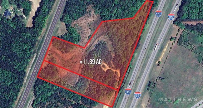
3 AC
Commercialacreage
North Carolina Northeast Area
RRB4
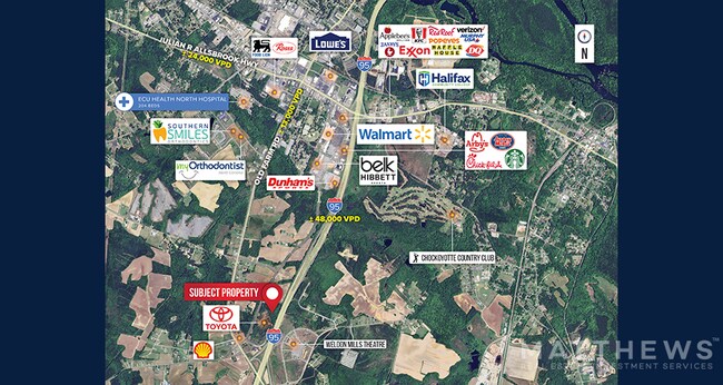
NEARBY LISTINGS FOR SALE OR LEASE
DEMOGRAPHICS near Premier Boulevard Ext
1 mile
3 mile
5 mile
2025 Total Population
352
9,934
24,037
2030 Population
347
9,682
23,268
Pop Growth 2025-2030
(1.42%)
(2.54%)
(3.20%)
Average Age
45
43
42
2025 Total Households
158
4,467
10,279
HH Growth 2025-2030
(1.27%)
(2.64%)
(3.26%)
Median Household Inc
$36,363
$38,268
$47,371
Avg Household Size
2.10
2.20
2.30
2025 Avg HH Vehicles
2.00
2.00
2.00
Median Home Value
$228,125
$136,062
$123,652
Median Year Built
1987
1979
1976
Nearby Places
Map Layers
Map Styles
 Street
 Aerial
Transit
 Traffic
 Biking
Places
Listings with unknown addresses are not visible on the map
- Restaurants
- Banks
- Shops
- Fitness
- Groceries
SALE & LEASE HISTORY
LISTING DATE
SALE/LEASE

May 24, 2024
For Sale
Nearby Properties
Address
Land Use
TOTAL SIZE
Lot Size
Zoning
Address
Land Use
TOTAL SIZE
Lot Size
Zoning
50,336 SF
113.40 AC
WELI1
Address
Land Use
TOTAL SIZE
Lot Size
Zoning
239,194 SF
48.24 AC
RRB5
Address
Land Use
TOTAL SIZE
Lot Size
Zoning
74,953 SF
107.43 AC
Address
Land Use
TOTAL SIZE
Lot Size
Zoning
203,628 SF
17.91 AC
RRB4
Address
Land Use
TOTAL SIZE
Lot Size
Zoning
11,283 SF
3.66 AC
Address
Land Use
TOTAL SIZE
Lot Size
Zoning
66,609 SF
2.60 AC
RRB4
Address
Land Use
TOTAL SIZE
Lot Size
Zoning
110,678 SF
11.34 AC
RRB4
Address
Land Use
TOTAL SIZE
Lot Size
Zoning
2.05 AC
WELCH
Address
Land Use
TOTAL SIZE
Lot Size
Zoning
13,794 SF
11.34 AC
RRR
Address
Land Use
TOTAL SIZE
Lot Size
Zoning
8,200 SF
5.97 AC
RRB4
Address
Land Use
TOTAL SIZE
Lot Size
Zoning
14,000 SF
13.66 AC
RRB4
Address
Land Use
TOTAL SIZE
Lot Size
Zoning
75,392 SF
4.22 AC
RRR
Address
Land Use
TOTAL SIZE
Lot Size
Zoning
58,891 SF
2.65 AC
WELR8
Address
Land Use
TOTAL SIZE
Lot Size
Zoning
14,300 SF
10 AC
RRB4
Address
Land Use
TOTAL SIZE
Lot Size
Zoning
45,205 SF
8.82 AC
Address
Land Use
TOTAL SIZE
Lot Size
Zoning
75,353 SF
10 AC
RRR6
Address
Land Use
TOTAL SIZE
Lot Size
Zoning
87,165 SF
8.77 AC
RRB4
Address
Land Use
TOTAL SIZE
Lot Size
Zoning
46,948 SF
2.31 AC
RRB4
Address
Land Use
TOTAL SIZE
Lot Size
Zoning
4.47 AC
RRB4
Address
Land Use
TOTAL SIZE
Lot Size
Zoning
68,153 SF
20 AC
WELR8
Address
Land Use
TOTAL SIZE
Lot Size
Zoning
28,316 SF
10.19 AC
RRB4
Address
Land Use
TOTAL SIZE
Lot Size
Zoning
132,851 SF
35.37 AC
Address
Land Use
TOTAL SIZE
Lot Size
Zoning
47,641 SF
2.15 AC
RRB4
Address
Land Use
TOTAL SIZE
Lot Size
Zoning
74,222 SF
10.70 AC
RRB4
Address
Land Use
TOTAL SIZE
Lot Size
Zoning
Address
Land Use
TOTAL SIZE
Lot Size
Zoning
1,647 SF
15.43 AC
WELR40
Address
Land Use
TOTAL SIZE
Lot Size
Zoning
30,762 SF
8.30 AC
RRB
Address
Land Use
TOTAL SIZE
Lot Size
Zoning
17,828 SF
17.59 AC
Address
Land Use
TOTAL SIZE
Lot Size
Zoning
18,024 SF
3.75 AC
RRB5
Address
Land Use
TOTAL SIZE
Lot Size
Zoning
152,210 SF
20.39 AC
The World's #1 Commercial Real Estate Marketplace
Connect with us
© 2026 CoStar Group
The information above has been obtained from sources believed reliable. While we do not doubt its accuracy we have not verified it and make no guarantee, warranty or representation about it. It is your responsibility to independently confirm its accuracy and completeness. Any projections, opinions, assumptions, or estimates used are for example only and do not represent the current or future performance of the property. The value of this transaction to you depends on tax and other factors which should be evaluated by your tax, financial, and legal advisors. You and your advisors should conduct a careful, independent investigation of the property to determine to your satisfaction the suitability of the property for your needs.