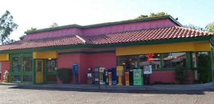
Property Record
1250 W Broadway Rd, Tempe, AZ 85282

NEARBY LISTINGS FOR SALE OR LEASE
Property Detail
1250 W Broadway Rd
124-75-042E
Sonoran Vista
Restaurantdrivein
BEG SW COR OF E 317.5F OF W 1052.50F OF SW4 SW4 TH N 40F E 25F TO TR POB N 68.73F N 37D29M E 164. 28F E 192.5F S 200F W 292.50F TPOB EX TRI IN SW COR & EX RD P/D 83 376984
X
Maricopa
04013C2240M
Arizona
2025
1.06 AC
2025
Tempe
318900
Phoenix
4,233 SF
Phoenix-Mesa-Chandler, AZ
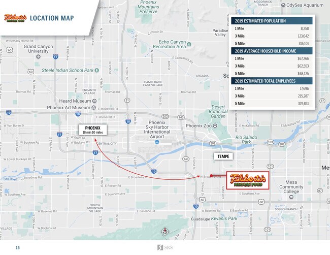
DEMOGRAPHICS near 1250 W Broadway Rd
1 Mile
3 Mile
5 Mile
2024 Total Population
8,797
124,849
317,839
2029 Population
9,476
134,788
344,042
Pop Growth 2024-2029
+ 7.72%
+ 7.96%
+ 8.24%
Average Age
34
33
35
2024 Total Households
3,618
50,722
130,729
HH Growth 2024-2029
+ 7.79%
+ 8.51%
+ 8.55%
Median Household Inc
$66,061
$58,626
$63,607
Avg Household Size
2.30
2.20
2.30
2024 Avg HH Vehicles
2.00
2.00
2.00
Median Home Value
$379,046
$329,494
$351,699
Median Year Built
1970
1983
1982
Nearby Places
Map Layers
Map Styles
 Street
 Aerial
- Restaurants
- Banks
- Shops
- Fitness
- Groceries
PUBLIC TRANSPORTATION
AIRPORT
Phoenix Sky Harbor International
DRIVE
WALK
Distance
Phoenix Sky Harbor International
11 min
5.1 mi
Phoenix-Mesa Gateway
DRIVE
WALK
Distance
Phoenix-Mesa Gateway
36 min
24.4 mi
SALE & LEASE HISTORY
LISTING DATE
SALE/LEASE

Jun 03, 2020
For Sale
Nearby Properties
Address
Land Use
TOTAL SIZE
Lot Size
Zoning
Address
Land Use
TOTAL SIZE
Lot Size
Zoning
4.59 AC
I-1
Address
Land Use
TOTAL SIZE
Lot Size
Zoning
75,000 SF
12.19 AC
I-1
Address
Land Use
TOTAL SIZE
Lot Size
Zoning
2.63 AC
I-1
Address
Land Use
TOTAL SIZE
Lot Size
Zoning
Address
Land Use
TOTAL SIZE
Lot Size
Zoning
401,544 SF
64.59 AC
GID
Address
Land Use
TOTAL SIZE
Lot Size
Zoning
81,816 SF
7.95 AC
Address
Land Use
TOTAL SIZE
Lot Size
Zoning
2,089,643 SF
33.80 AC
MU-ED
Address
Land Use
TOTAL SIZE
Lot Size
Zoning
1,227,029 SF
7.39 AC
R-6
Address
Land Use
TOTAL SIZE
Lot Size
Zoning
106,575 SF
2.50 AC
I-1
Address
Land Use
TOTAL SIZE
Lot Size
Zoning
1,056,321 SF
35.93 AC
R1-6
Address
Land Use
TOTAL SIZE
Lot Size
Zoning
5.13 AC
Address
Land Use
TOTAL SIZE
Lot Size
Zoning
94,162 SF
9.40 AC
I-2
Address
Land Use
TOTAL SIZE
Lot Size
Zoning
1,102,629 SF
12.33 AC
R-3
Address
Land Use
TOTAL SIZE
Lot Size
Zoning
1,479,006 SF
84.96 AC
C-R
Address
Land Use
TOTAL SIZE
Lot Size
Zoning
2.54 AC
Address
Land Use
TOTAL SIZE
Lot Size
Zoning
571,804 SF
0.98 AC
CSS
Address
Land Use
TOTAL SIZE
Lot Size
Zoning
1,020,776 SF
11.33 AC
I-1
Address
Land Use
TOTAL SIZE
Lot Size
Zoning
331,050 SF
39 AC
I-1
Address
Land Use
TOTAL SIZE
Lot Size
Zoning
58,061 SF
5.43 AC
C-C
Address
Land Use
TOTAL SIZE
Lot Size
Zoning
697,894 SF
8.43 AC
PAD
Address
Land Use
TOTAL SIZE
Lot Size
Zoning
32,968 SF
2.10 AC
I-P
Address
Land Use
TOTAL SIZE
Lot Size
Zoning
511,014 SF
5.01 AC
I-1
Address
Land Use
TOTAL SIZE
Lot Size
Zoning
548,227 SF
1.62 AC
C-G
Address
Land Use
TOTAL SIZE
Lot Size
Zoning
746,457 SF
20.95 AC
I-1
Address
Land Use
TOTAL SIZE
Lot Size
Zoning
352,244 SF
5.55 AC
R-6
Address
Land Use
TOTAL SIZE
Lot Size
Zoning
368,727 SF
12.77 AC
R1-6
The World's #1 Commercial Real Estate Marketplace
Connect with us
© 2026 CoStar Group
The information above has been obtained from sources believed reliable. While we do not doubt its accuracy we have not verified it and make no guarantee, warranty or representation about it. It is your responsibility to independently confirm its accuracy and completeness. Any projections, opinions, assumptions, or estimates used are for example only and do not represent the current or future performance of the property. The value of this transaction to you depends on tax and other factors which should be evaluated by your tax, financial, and legal advisors. You and your advisors should conduct a careful, independent investigation of the property to determine to your satisfaction the suitability of the property for your needs.