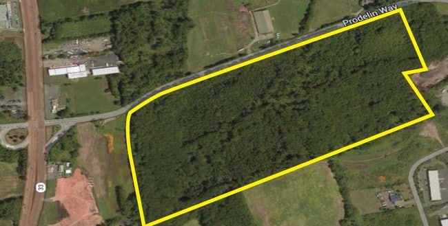
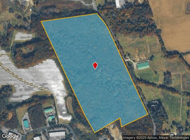
Property Record
Prodelin Way, Millstone Twp, NJ 08535
NEARBY LISTINGS FOR SALE OR LEASE
-
-
No Photo
-
-
-
-
-
-
View all Millstone Twp listings for sale on LoopNet.com
Property Detail
Prodelin Way
33-00016-0000-00010
Monmouth
Vacantlandnec
New Jersey
A
10
34023C0268F
56 AC
2024
Western Monmouth
2025
Northern New Jersey
812501
Lakewood-New Brunswick, NJ
DEMOGRAPHICS near Prodelin Way
1 mile
3 mile
5 mile
2024 Total Population
363
16,354
61,000
2029 Population
360
16,316
60,676
Pop Growth 2024-2029
(0.83%)
(0.23%)
(0.53%)
Average Age
41
42
46
2024 Total Households
110
5,559
23,374
HH Growth 2024-2029
(0.91%)
(0.38%)
(0.96%)
Median Household Inc
$188,888
$138,330
$113,437
Avg Household Size
3.10
2.80
2.50
2024 Avg HH Vehicles
3.00
2.00
2.00
Median Home Value
$630,597
$531,291
$446,046
Median Year Built
1992
1996
1989
Nearby Places
Map Layers
Map Styles
 Street
 Aerial
Transit
 Traffic
 Biking
Places
Listings with unknown addresses are not visible on the map
- Restaurants
- Banks
- Shops
- Fitness
- Groceries
PUBLIC TRANSPORTATION
AIRPORT
Trenton Mercer
Drive
Walk
Distance
Trenton Mercer
40 min
26.4 mi
Freight Ports
New York Container Terminal
Drive
Walk
Distance
New York Container Terminal
51 min
39.9 mi
Nearby Properties
Address
Land Use
TOTAL SIZE
Lot Size
Zoning
Address
Land Use
TOTAL SIZE
Lot Size
Zoning
3,060 SF
114.66 AC
PCD
Address
Land Use
TOTAL SIZE
Lot Size
Zoning
220,000 SF
25.42 AC
PCD
Address
Land Use
TOTAL SIZE
Lot Size
Zoning
12.27 AC
PCD
Address
Land Use
TOTAL SIZE
Lot Size
Zoning
15 AC
PUD
Address
Land Use
TOTAL SIZE
Lot Size
Zoning
63.69 AC
HD
Address
Land Use
TOTAL SIZE
Lot Size
Zoning
136 AC
R-40
Address
Land Use
TOTAL SIZE
Lot Size
Zoning
56.30 AC
Address
Land Use
TOTAL SIZE
Lot Size
Zoning
186,660 SF
9.22 AC
PUD
Address
Land Use
TOTAL SIZE
Lot Size
Zoning
2,611 SF
5.23 AC
HDRA
Address
Land Use
TOTAL SIZE
Lot Size
Zoning
9.63 AC
SED2W
Address
Land Use
TOTAL SIZE
Lot Size
Zoning
0.01 AC
CC
Address
Land Use
TOTAL SIZE
Lot Size
Zoning
1,150,128 SF
8.44 AC
PUD
Address
Land Use
TOTAL SIZE
Lot Size
Zoning
1,914 SF
12 AC
HD
Address
Land Use
TOTAL SIZE
Lot Size
Zoning
46,930 SF
12.39 AC
HC
Address
Land Use
TOTAL SIZE
Lot Size
Zoning
11.78 AC
HD
Address
Land Use
TOTAL SIZE
Lot Size
Zoning
40,162 SF
5.98 AC
R60
Address
Land Use
TOTAL SIZE
Lot Size
Zoning
113,700 SF
7.15 AC
HD
Address
Land Use
TOTAL SIZE
Lot Size
Zoning
52,557 SF
7.98 AC
PUD
Address
Land Use
TOTAL SIZE
Lot Size
Zoning
9.56 AC
SED/
Address
Land Use
TOTAL SIZE
Lot Size
Zoning
22,332 SF
17.10 AC
R60
Address
Land Use
TOTAL SIZE
Lot Size
Zoning
10.04 AC
BP
Address
Land Use
TOTAL SIZE
Lot Size
Zoning
80 AC
FHC
Address
Land Use
TOTAL SIZE
Lot Size
Zoning
34,260 SF
3.40 AC
PCD
Address
Land Use
TOTAL SIZE
Lot Size
Zoning
1.93 AC
HD
Address
Land Use
TOTAL SIZE
Lot Size
Zoning
7.91 AC
BP
Address
Land Use
TOTAL SIZE
Lot Size
Zoning
5 AC
SED2W
Address
Land Use
TOTAL SIZE
Lot Size
Zoning
2,354 SF
29.10 AC
SF80
Address
Land Use
TOTAL SIZE
Lot Size
Zoning
Address
Land Use
TOTAL SIZE
Lot Size
Zoning
2,744 SF
43.38 AC
PCD
Address
Land Use
TOTAL SIZE
Lot Size
Zoning
54.15 AC
SF80
The World's #1 Commercial Real Estate Marketplace
Connect with us
© 2026 CoStar Group
The information above has been obtained from sources believed reliable. While we do not doubt its accuracy we have not verified it and make no guarantee, warranty or representation about it. It is your responsibility to independently confirm its accuracy and completeness. Any projections, opinions, assumptions, or estimates used are for example only and do not represent the current or future performance of the property. The value of this transaction to you depends on tax and other factors which should be evaluated by your tax, financial, and legal advisors. You and your advisors should conduct a careful, independent investigation of the property to determine to your satisfaction the suitability of the property for your needs.