Property Record
Fm 1015, Weslaco, TX 78596
Property Detail
Fm 1015
McAllen/Edinburg/Pharr
LLANO GRANDE ALL LOT 56 20.00AC GR 19.70AC NET
McAllen-Edinburg-Mission, TX
HIDALGO
L5025-00-000-0022-10
Texas
Farms
56
2024
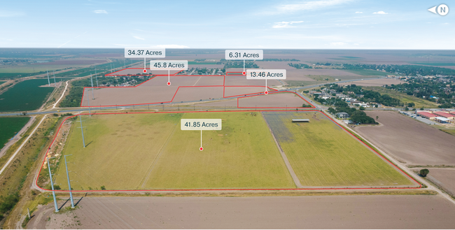
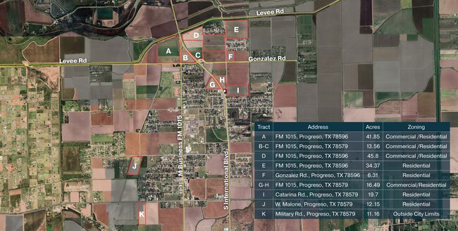
41.85 AC
2025
Outlying Hidalgo County
022801
NEARBY LISTINGS FOR SALE OR LEASE
DEMOGRAPHICS near Fm 1015
1 mile
3 mile
5 mile
2025 Total Population
3,003
23,521
64,850
2030 Population
2,965
25,010
68,633
Pop Growth 2025-2030
(1.27%)
+ 6.33%
+ 5.83%
Average Age
33
40
37
2025 Total Households
783
8,084
20,976
HH Growth 2025-2030
(1.40%)
+ 7.56%
+ 6.32%
Median Household Inc
$48,194
$53,717
$52,292
Avg Household Size
3.80
2.80
3.00
2025 Avg HH Vehicles
2.00
2.00
2.00
Median Home Value
$85,890
$96,415
$122,331
Median Year Built
1995
1994
1993
Nearby Places
Map Layers
Map Styles
 Street
 Aerial
Transit
 Traffic
 Biking
Places
Listings with unknown addresses are not visible on the map
- Restaurants
- Banks
- Shops
- Fitness
- Groceries
PUBLIC TRANSPORTATION
AIRPORT
McAllen International
Drive
Walk
Distance
McAllen International
32 min
23.3 mi
Valley International
Drive
Walk
Distance
Valley International
36 min
26.2 mi
Freight Ports
Port of Brownsville
Drive
Walk
Distance
Port of Brownsville
53 min
45.5 mi
SALE & LEASE HISTORY
LISTING DATE
SALE/LEASE

Jun 12, 2024
For Sale
Nearby Properties
Address
Land Use
TOTAL SIZE
Lot Size
Zoning
Address
Land Use
TOTAL SIZE
Lot Size
Zoning
184,092 SF
17.61 AC
Address
Land Use
TOTAL SIZE
Lot Size
Zoning
2 SF
48.88 AC
GT
Address
Land Use
TOTAL SIZE
Lot Size
Zoning
342,760 SF
42.33 AC
Address
Land Use
TOTAL SIZE
Lot Size
Zoning
76,484 SF
20.60 AC
Address
Land Use
TOTAL SIZE
Lot Size
Zoning
3 SF
16.78 AC
Address
Land Use
TOTAL SIZE
Lot Size
Zoning
9 SF
21.03 AC
Address
Land Use
TOTAL SIZE
Lot Size
Zoning
132,797 SF
7.88 AC
Address
Land Use
TOTAL SIZE
Lot Size
Zoning
8 SF
5 AC
Address
Land Use
TOTAL SIZE
Lot Size
Zoning
1 SF
12.23 AC
Address
Land Use
TOTAL SIZE
Lot Size
Zoning
39,592 SF
12.22 AC
Address
Land Use
TOTAL SIZE
Lot Size
Zoning
1 SF
21.22 AC
Address
Land Use
TOTAL SIZE
Lot Size
Zoning
22,144 SF
55.59 AC
Address
Land Use
TOTAL SIZE
Lot Size
Zoning
39,875 SF
5.46 AC
AO
Address
Land Use
TOTAL SIZE
Lot Size
Zoning
15,250 SF
28.36 AC
CO
Address
Land Use
TOTAL SIZE
Lot Size
Zoning
110,725 SF
6.74 AC
Address
Land Use
TOTAL SIZE
Lot Size
Zoning
12,148 SF
17.84 AC
M3
Address
Land Use
TOTAL SIZE
Lot Size
Zoning
18,618 SF
33.88 AC
M2
Address
Land Use
TOTAL SIZE
Lot Size
Zoning
63,104 SF
2.41 AC
Address
Land Use
TOTAL SIZE
Lot Size
Zoning
50,699 SF
11.40 AC
Address
Land Use
TOTAL SIZE
Lot Size
Zoning
16,941 SF
43.25 AC
M3
Address
Land Use
TOTAL SIZE
Lot Size
Zoning
39,200 SF
4.99 AC
Address
Land Use
TOTAL SIZE
Lot Size
Zoning
28,626 SF
1.89 AC
CO
Address
Land Use
TOTAL SIZE
Lot Size
Zoning
75,576 SF
6.48 AC
Address
Land Use
TOTAL SIZE
Lot Size
Zoning
3 SF
50.61 AC
Address
Land Use
TOTAL SIZE
Lot Size
Zoning
52,926 SF
9.89 AC
Address
Land Use
TOTAL SIZE
Lot Size
Zoning
105,028 SF
10.19 AC
Address
Land Use
TOTAL SIZE
Lot Size
Zoning
57,123 SF
8.28 AC
Address
Land Use
TOTAL SIZE
Lot Size
Zoning
8,117 SF
28.68 AC
M3
Address
Land Use
TOTAL SIZE
Lot Size
Zoning
13,440 SF
36.89 AC
Address
Land Use
TOTAL SIZE
Lot Size
Zoning
1,668,585 SF
2.08 AC
The World's #1 Commercial Real Estate Marketplace
Connect with us
© 2026 CoStar Group
The information above has been obtained from sources believed reliable. While we do not doubt its accuracy we have not verified it and make no guarantee, warranty or representation about it. It is your responsibility to independently confirm its accuracy and completeness. Any projections, opinions, assumptions, or estimates used are for example only and do not represent the current or future performance of the property. The value of this transaction to you depends on tax and other factors which should be evaluated by your tax, financial, and legal advisors. You and your advisors should conduct a careful, independent investigation of the property to determine to your satisfaction the suitability of the property for your needs.